Turkey Marmara – April 21-23 2019
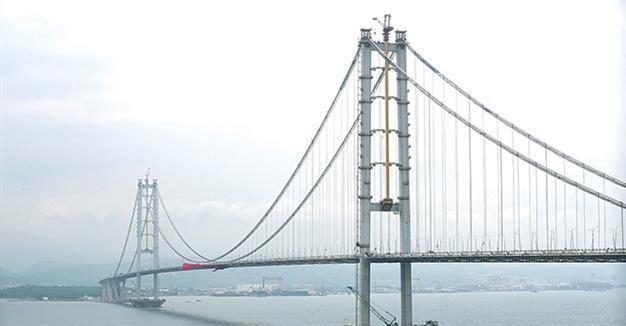
Osmangazi Bridge. The 2,682-meter-long Osmangazi Bridge over the Marmara Sea is said to be the fourth-longest suspension bridge in the world & the second-longest in Europe. The $1.3 billion bridge is named after Osman Gazi, the founder and first sultan of the Ottoman Empire. The bridge aims to drastically cut travel time between Istanbul and the country’s western provinces. The construction of the quake-resistant bridge began in 2010. Erdogan has for years championed expanding the country’s airport and road facilities to achieve better connectivity between provinces.
The toll just for the bridge was a whopping 103 TL (€16).


BURSA
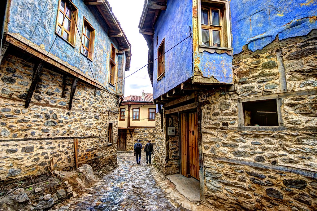
Bursa was the first capital of the Ottoman Empire from 1335-63. Bursa and Cumalıkızık: the Birth of the Ottoman Empire form a combined World Heritage Site.
Tofaş Museum of Cars and Anatolian Carriages. Housed in a 19th-century car factory restored into a gorgeous facility in 1998, this was a pleasant surprise. Most exhibits are ancient horse-drawn chariots, carriages, wagons and painted carts, a blacksmith shop for shoeing horses, and saddle, wheel and bridle manufacturing exhibits. It suddenly morphs into cars, some Turkish Murat and San Tipo brands and several new Fiats.
In an old hamam below the main museum is a very extensive museum on balances, scales, weights and volume measurements. The grounds have one huge tree.
Bursa City Museum. Completely in Turkish, this museum was kind of a lost cause. I assumed that the first five old guys (with models) were the first five sultans of the Ottoman Empire. The 1937 Ford car used by the mayor may have been the highlight and we cruised through. Free
Ulu Cami’i (Bursa Grand Mosque). We visited this mosque on a Saturday afternoon when it was crowded with many simply relaxing on the carpet. Little kids were running around and playing. It is a large square with 20 domes, the right central one with a glass ceiling over a large 16-sided ablution fountain (guys were not only washing their feet but also faces, hair and arms). The inside is plain white with some unexciting stenciled crests and several framed Arabic writings. It has a lovely gilded mihrab and a single huge brick minaret.
Bursa Archaeological Museum. This is a mediocre museum with the usual exhibits starting in the Stone Age and moving through Greek and Roman times with a huge number of pots, several statues (including the best, bronzes of Apollo and Athena), some mosaics, a horse and chariot and a boring coin exhibit upstairs. Free
Merinos Textile Museum. On 3 floors, this large museum had an immense number of machines – most looms, power looms and dying machines – and a lot of clothed mannequins showing the finished product of the textile industry in Bursa. The little bit of English relayed little information. The highlight for me was the Orhan Holdings 2018 photographic competition winners, some wonderful photography mostly from South Asia. Free
Bursa Botanic Park. In north Bursa, this huge park has many mature trees and well-designed flower beds in full bloom. The grass needed cutting. We saw the fourth wedding party of the day here. The bride wore an over-the-top extravagant pinky-red dress. Free
Uluabat Gölü. This large lake is about 45kms west of Bursa. We drove out here and camped on the side in a small town. Facing west, we saw a great sunset. There are a lot of birds, then names of which I did not know.
The drive to Canakkale was through rural farm country. Many fields were planted in canola, with its bright yellow blossom, a lovely contrast to the green fields.
Bird Paradise National Park (Kiscenneti Milli Parki). Formed in 1959, this park has a small museum full of stuffed birds, birds eggs, snakes, fish. All labels, but the eggs, were the scientific name and the Turkish name. We then walked down to the lookout tower above several platforms on the water full of nesting pelicans. The trees were full of a black bird (cormorant?) also actively nesting. 7 TL, Free reduced
Kapidağ Peninsula. This peninsula juts out from the north shore of the mainland. Most of the towns were on the south shore with Erdek the main one. The peninsula is quite hilly and covered in olive trees.
We returned to Thrace and the Gallipoli Peninsula on April 22.
CANAKKALE/GALLIPOLI (Gelibolu): Çanakkale (Dardanelles) and Gelibolu (Gallipoli) Battles Zones in the First World War are together a tentative WHS (15/04/2014). The Gallipoli Peninsula is both a NM “Sight” and in the “XL” series. Ataturk rose as a military leader during these campaigns.
The Allies wanted to capture Istanbul and Turkey for several reasons in WW I. They wanted to eliminate Turkey as an ally to Germany; they wanted an ice-free access to Russia and they wanted another front on which to fight Germany and Austro-Hungary. The only way to capture Istanbul was via the Dardanelles.
This was a 9-month battle fought between the British-led forces (including many Commonwealth countries, especially New Zealanders and Australians) and the Ottoman Empire allied with Germany in WW I. The first offence occurred between the British Navy and the land-based defence of the Ottomans on both sides of the Dardanelles on March 18, 2015. The second attack started on April 25 when the Allies attacked via land on the north shore of the Gallipoli Peninsula. The third major offensive started on August 8 with another land attack. The fourth phase was the evacuation of the peninsula in December 2015.
In the nine months from March to December 1915, the death tolls were: 34,072 British, 9,798 French, 8,709 Australian, 2,721 New Zealanders, 1,358 Indians, 49 Newfoundlanders, and 56,643 Ottoman Empire soldiers died. Missing or POW were 7,654 British and 11,178 Ottomans,
Wounded totals were Allies 123,598 and Ottomans 97,007.
The Dardanelles have always been key to protecting Istanbul and access to the Black Sea especially for the least 600 years since 1453. In 1461-2, two fortresses were built on either side of the Dardanelles at the narrowest part – Kilitbehir on the European side and Kale-e Sultanye on the Asian side both fortified with cannons. Made ineffective by pirates and the 1650-57 Venetian attacks, 2 more fortresses were built in 1660. All were updated in the 1800’s. The British managed to get through due to strong winds in 1807 and the forts were reinforced again. In 1907, the telegraph improved defences through better communication and 35 land batteries and ramparts were added. Gelibolu Fortress in Canakkale was the centre of the defence.
CANAKKALE
On the Asian side of the Dardanelles, it has a wide, attractive promenade along the shore, full of people out walking on a Sunday.
Truva Heykeli (Trojan Statue). In the NM “Modern Architecture: Buildings and Monuments” series, this is a replica of Trojan Horse, a great wooden structure on the promenade. The legs are held together with rope lashing.
As narrated in the Iliad by Homer, the Achaens who had failed to capture the wealthy city of Troy after 10 years of war, made a wooden horse, hid warriors in it, left it in front of the gates of the city and sailed away. The Troy citizens brought the horse into the town. Waiting until dark, the Greek warriors opened the gates and set Troy on fire.
This model horse was used in the 2004 Warner Bros production starring Brad Pitt as Achilles and has been on display in Canakkale since September 2004.
Canakkale City Museum. The usual city museum but this one focuses more on the battle of 1915 and the fortresses lining the shore. 10 TL
Military Marine Museum and Gelibolu Fortress, Canakkale. Mostly an open-air museum with artillery, canons, torpedoes and water mines, there is also a German submarine that hit a mine, which was recovered and placed on the grounds.
Tour the TCG Nusret ship museum moored in the harbour. It is famous as the boat that laid most of the sea mines crucial in the Turkish defences of WWI. Inside watch an hour-by-hour recreation of the March 15, 1915 battle between the British Navy and the land defences at Canakkale, where the British eventually had to retreat after heavy losses. See the kitchen, crew’s, captain’s and petty officer’s quarters, wardroom and sick bay, all nicely restored.
Fortress: It is 150 X 100m with 5-7m thick walls and 9 bastions. Enter the fortress where there are photographs of heavy shell damage to the mosque and corner of the inner fortress. An unexploded shell fired by the Queen Elizabeth warship is embedded in the wall. March 18 is a national holiday in Turkey – “Battleship Day”, one of immense pride to Turks after defeating the British Navy.
Inside the central fort is 2-stories of displays detailing the New Zealand/Australian (ANZAC) attack on the north shore of the Gallipoli Peninsula.
We took the ferry across the Dardanelles to the Gallipoli Peninsula. It departs from Lapseki, about 35kms north of Canakkale (55 TL, every 30 minutes). Google Maps showed a crossing from the city of Canakkale but there isn’t so we had to retrace our steps back.
GALLIPOLI
Two 30,000-strong Allied divisions landed on the north Gallipoli coast from April 25 to May 16.
Akbas Sehitliga (Akbas Martyrs Monument). Shortly after getting off the ferry, we passed this Turkish cemetery/monument from WWI. Akbas was a hospital complex active in the war. 1,213 soldiers died in the hospital and are buried here – 459 have gravestones and 754 are memorialized on a big wall at the back of the cemetery. Almost all are dated 1915 but some from 1916.
Lone Pine Cemetery, Gallipoli. In the NM “The Dark Side” series, this is the largest Australian cemetery on Gallipoli – 1,160 servicemen (500 unidentified) have gravestones. A memorial wall commemorates 5,000 Australian and New Zealand men with no known grave who died mostly between April 25 to evacuation in December 2015, and most of those during the major offensive that started on August 8. On August 6, the British Navy artillery pounded Ottoman trenches (where Lone Pine is). The attack was intended to divert Ottoman forces from the major offensive at Sari Bay farther north. It was a brutal battle involving hand-to-hand combat in the trenches with revolvers, rifles and bayonets. 2000 Australians and 7000 Ottomans died in the next 7 months, but Lone Pine was held until the evacuation in December. 7 Australians were awarded the Victoria Cross.
The one-way road snakes along the ridgeline, the control of which was the objective of the land-based attack. The road is littered with smaller cemeteries and signs naming specific locations. Many trenches are still easily visible along the road.
The cemeteries of WW I and WW II are looked after by the Commonwealth War Graves Commission (www.cwgc.org). 1,700,000 Commonwealth citizens died in the two wars.
Çanakkale Martyrs’ Memorial. On the very south tip of the Gallipoli Peninsula, this is the major Turkish memorial to WW I. First pass several rows of gravestones – marble rectangles surrounding a red clear plastic centre with 36 names. Enter a large square with a huge flagpole and a wonderful bas-relief memorial on the east side. The monument itself is a massive 70m high stone structure on a high point of land. A Turkey flag is on the bottom of the roof. It is lit at night and must be visible for miles in all directions.
April 25 is ANZAC day and all the cemeteries were being set up for the celebrations when 3000 New Zealanders and Australians arrived for the memorial. Bandstands, large sound systems and posters were all over this memorial and others.

We parked for the night next to the memorial on the edge of the cliff for a 180° panorama of city lights across the east and south horizon.
On the way to Kilitbahir, we passed at least 50 vans full of police. Every intersection was controlled. Then there were a lot of buses. At the ferry, hundreds of foot passengers disembarked. I asked some policemen what was happening. As nobody spoke English, they translated on their phone “There is a ceremony” – in fact, it was the Memorial Holiday the next day.
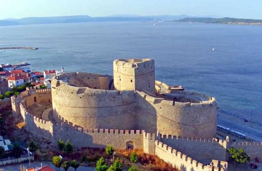
Kilitbahir Castle. On the European side of the Dardanelles opposite Canakkale, this is a tremendous fortress of three huge, round lobes and a tall central “keep”. Gun batteries line the shore facing west. 10 TL

Just after Kilitbahir, I noticed a ferry – and it went directly to Canakkale, saving 70kms of driving. We had asked some police in Canakkale about the ferry crossing to Gallipoli and he had only mentioned the one at Lapseki. Crazy. 55 TL
ARCHAEOLOGICAL SITE of TROY
The site of Troy had 9 building periods. The archaeological dig shows most of them, often built over each other. At one place, all 9 periods can be seen in one cliff face. The treasures of Troy are in museums in 7 different cities (including since WW II, St Petersburg and Moscow). Walk on the boardwalk through the site. Most take some imagination to see.
Troy I (3000-2500 BC) – Built on the bedrock, the enclosed settlement was originally timbered around a 90m diameter enclosure. This was one of the first places in the world to have produced bronze.
Troy II (2500-2300 BC) – There are fragments of foundations, megairon houses and the Citadel wall. On top of these stone walls were mud plastered wattle and mud brick walls (the archaeological dig exposes them and they are protected by a large canvas awning).
Troy III, IV and V (2300-1700 BC)
Troy VI (1700-1250 BC) – Palace complex with a superstructure of timber and brick. Destroyed in 1250 by an earthquake.
Troy VIIa, b, b2 (1230-1000 BC) – These were all destroyed by fires.
Troy VIII (1000-85 BC) Greeks settled here first in about 800 BC and called it Llion. It was visited by the Persian king Xerxes in 450 BC and by Alexander the Great in 330 BC. Most were built in the 4th century BC (the East wall was 6m high, 550m long of which 350m remain today surrounding the Citadel, theatre, 2-story East tower, and East palaces) and was destroyed by the renegade Roman Fimbia in 85 BC. Parts of the Temple of Athena metopes are in Berlin.
Troy IX (85 BC-500 AD) – Augustus (31 BC-14 AD) renovated the city. The Romans believed the first Romans came from Troy whose citizens had fled to Italy after the Trojan War.
Besides the archaeological dig, there is a very fake Trojan Horse and the Pathos Garden (with huge amphorae storage containers, terracotta water pipes and grinding stones).
Cape Baba. In the NM “XL” series, this is the westernmost point of Asia. In the tiny village of Babakale with a fort on the water, we went down to the harbour, parked and had lunch. A large quay/breakwater protects the small marina and one large pleasure yacht was parked. Rugged cliffs back the marina. The island of Ag Efstratioa is offshore to the south and more westerly than this point.
Archaeological Site of Assos (Kuyumcu). We parked down at the bottom of the village and walked up the rough cobble street past a gaggle of knick-knack shops, a newish mosque and a few lovely stone buildings near the top of the hill. An old mosque here has a nice dome but no minaret. The Archaeological site consists of the Acropolis with a square tower, half a round tower, many crumbling foundation walls and the rocky top of the mountain.
The best are the great Roman walls at the bottom with precisely cut stone blocks. The road continues past more walls to a necropolis, ruined theatre, gymnasium, agora, more great walls and a nice Roman road, but this area was under renovation. 15 TL

AYVALIK ISLANDS
Alibey islands. The largest of Ayvalik Islands, it can be driven to via two bridges.
Ayvalık Industrial Landscape Tentative WHS
On Christmas Day, 2019, I drove from Assos to Greece. I crossed the Dardanelles at Canakkale by ferry (€15, as I didn’t have enough Turkish lira. Turkey is building a huge bridge across the Dardanelles, another of their mega highway projects.
