Montenegro Central and Coast March 27-29, 2019.
Another country and this one with some differences. First it is a country I had rarely heard of. Part of the former Yugoslavia, it occupies the far south just above Albania and Macedonia. It was an independent country from 1868 to 1918, then was part of Serbia, then part of Yugoslavia and only an independent country since 2006.
1. English. Few people speak English except in tourist towns like Kotor.
2. Currency: Unlike BH where all money seems to be completely interchangeable (Euros, Kn, BH currency), only Km is accepted here.
3. Vehicle Insurance. Proof of vehicle insurance is necessary to enter Montenegro. For confusing reasons, my initial “Green certificate” was only for one month (Jan 14-Feb 14) even though I had purchased it for one year. I had had a new certificate emailed to me (dated August 14!) but I had been neglectful and had not printed it. They would not let me enter so I went to a small office where the lovely gentleman let me use his wifi and I printed out the certificate. It was not in colour and said Duplicate at the top. This was not good enough as they required the original. I went back and purchased some sort of vehicle insurance for one month for 200 Kn (about $35€).
4. Drivers and Parking. There is an unusual mix of very slow “old men” and the usual very aggressive, fast-driving young people. It is understandable why Montenegro requires car insurance for everyone – the drivers are so bad. None signal, most talk on their phone when driving, they tailgate (like in Italy), cross into your lane on corners, run red lights, cut in front of you, and on and on. You must drive very defensively.
And because there are no motorcycles and everyone seems to have a car, parking is a nightmare. Double parking is routine.
5. Alphabets. Both Serbia Cyrillic and Latin alphabets are used. Occasionally Google Maps gives sites only in Cyrillic – try to figure those out.
6. Serbian Orthodox Churches. The common church here is Serbian Orthodox, similar but with some differences from Russian and Greek Orthodox churches. They are all remarkably similar: altar screens covered in icons, the congregation crosses themselves, touches the floor and kisses the most important icons (usually one of the Virgin and baby Jesus at the front left of every church and a small lectern at the front with an icon or bible on it), an invisible priest behind the altar screen reciting scripture in a staccato sing-song, priests with long hair, enormous beards and wearing a long black smock, many other icons throughout the church, the congregation stands as there are no pews (there are usually some choir seats around the periphery but they always seem empty), a heavy smell of incense and hanging from the dome an ornate “chandelier” – usually a round ring of ornate metal work.
7. No McDonalds or Lidl grocery stores. For the first time so far in Europe, neither of these dependable places exists. I am wifi challenged as a result but am yet to have to buy groceries, but I am sure I will not find cheap Lidl prices.
I had also not downloaded Google Maps past the border so was thankfully able to do that at the border too. Along with sorting out my car insurance, the whole process took well over an hour. Google Maps does not do a good job of Montenegro and took me on more than one driving adventure.
Savina Monastery, Herceg Novi. This is down by the road next to the coast but Google Maps took me to a winery well above that was accessed by narrow one-ways and I wasted ½ hour negotiating them.
Mass was happening when I visited this Serbian Orthodox monastery – monks with long hair and flowing beards in long black smocks, a lot of chanting from priests hidden behind the elaborate altar screen, incense, no pews and the congregation standing, everyone crossing themselves three times and touching the floor, repeating in front of a lovely silver icon of the Virgin, kissing the icon, and repeating in front of a small lecturn. The huge altar screen was covered with 44 icons. An immense chandelier surrounded by a square metal frame hung from the dome. All writing was in the Greek alphabet. Next to the main church was another much older and smaller church covered in faded frescoes. The monastery is surrounded by graveyards with photos of the deceased on the tombstones. A large vineyard is just below.
The drive to Kotor has two options. Most vehicles appeared to take the short ferry across to the peninsula where Kotor is at the tip, but I drove around the huge inlet. The road was a few metres from the water, very windy and slow.
Our Lady of the Rocks. In 1450, two sailors saw an image of the Virgin on a rock in the middle of the inlet. It took them 200 years to build the two islands. The small rock was in 20m of water and 100 ships and over 3000 tons of rock were dumped to form it. The virgin became the patron saint of sailors and the town – and the church their place of pilgrimage and devotion of thanks for “saving” their lives on their voyages around the world. The island is in the shape of a ship. July 22 is the festival day when the island was begun. The town has a 3500-year history including Greek and Roman remnants.
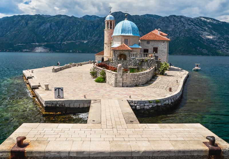
The small stone church with a blue dome is a wonder of art inside. Sixty-eight 17th century paintings of the life of the virgin took one artist ten years to produce, and cover the walls and ceiling. 2000 small silver plaques from sailors take up a middle band on the walls. The 300-year-old organ still functions. The church has about 50 masses per year.
The museum has several small rooms each with its own devotional items, most “gifts” giving thanks to the virgin: the sacristy has the only tombs on the island of the original two “keepers” of the island, Japanese objects, small steel crowns, paintings of storms, ships and battles, lanterns, household items (dishes, irons, sewing machines, clocks, locks, a gramophone), navigational instruments, guns, swords, many paintings of ships, a 500-year-old sailors chest, a painting of “the slaughter of the innocents” covering the top of one wall, a manual propeller with a 20:1 gear ratio, and the highlight, a small embroidery done by a woman who waited 25 years for her sailor husband to return (silk, gold, silver, pearl and her hair that turned from brown to grey over the life of the project).
The other small island of St George was originally a graveyard, has one building on it and is not visited by the boats. Boat ride 40Kn, museum 10Kn
Church of St Eustache (St. Eustatius), Dobrota: Eustache was a high-ranking officer in the army of Trajan. When hunting, he saw an image of the crucified Christ between the antlers of a deer and heard a voice from the sky. Eventually, his entire family died as martyrs and his birthday continues to be celebrated on September 20th in both Eastern and western churches as the protector and assistant in all life’s difficulties.
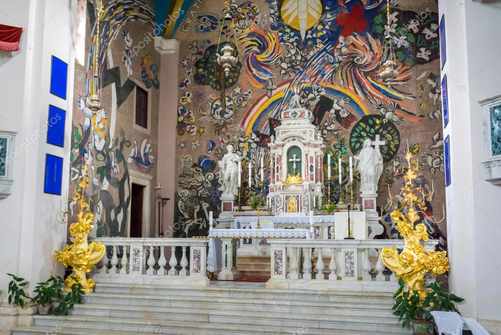
The first 1332 church here was destroyed in the 1667 earthquake and was replaced with a tiny church, not large enough for the congregation. The present church was started in 1762, is 36 x 16.5 x 16.5m high and adorned with 7 altars of variegated marble with paintings. The ceiling has 12 paintings with gilt frames done in 1932 showing the life and martyrdom of St Eustache (he looks like Hercules). The highlight is a huge modern 300 square metre mosaic in the presbytery with birds, rainbows and two crosses. The dome of the presbytery has brick ribs leading to an all-seeing eye on a blue background.
The 37.5m bell tower took 79 years to build and was finished in 1903. It has a 2m angel on the top. It was damaged in the 1979 earthquake and by three lightning bolts.
KOTOR
The medieval fortified old town backs onto a mountain and is fronted by a river. The stone walls ascend the mountain vertically up to the castle of San Giovanni (St John). The Natural and Culturo-Historical Region of Kotor is a World Heritage Site. Parking is a nightmare.
The town is a lovely jumble of tiny lanes and a few small squares. Stairs on either end of the town go up the mountain. They are a pleasant incline and make for wonderful views down to the old town, harbour and surrounding mountains.
Church of our Lady of Remedy. This small church with a prominent bell tower is about ¾ of the way to the fort. Unfortunately, it looks like it is always closed. It was even impossible to see anything inside.
Fort of San Giovanni. On the top of the mountain, it forms a wall across the entire mountain top. Narrow arrow slits are about one metre apart along the entire length of the wall. Make it to the flag poles at the top for truly spectacular views.
Cathedral of Saint Tryphon (Svetog Tripona). This 1124-66 small cathedral was heavily damaged in the 1667 earthquake and the tower took 17 years to rebuild. It has a brick rib vaulted ceiling and pillars. The museum is full of votive items, vestments and 809 relics, mostly of St Tryphon.
Maritime Museum. Has the usual boat models, maps, town maritime history, portraits and arms. The highlight is the eight 1m square bronze plaques in the entrance. €4
Cats Museum. Modelled after the Venice Cat Museum, it opened in 2013 and has made Kotor synonymous with cats. The original name of Kotor was Cattoro and the reason for the Kotor’s fascination with cats is somewhat obscure, but it is a quiet town fond of felines. Sailors returning from WWI in 1918 brought cats with them when they settled in the town. The museum has books, drawings, medals and coins, advertising, WWI history and some history of famous families and their cats. They sell exclusive cat souvenirs and offer registration in the museum complete with a certificate (info@catsmuseum.org – €2). They feed many of the cats and tourists are a common source of donations. €4
Many shops in the town have cat souvenirs.
Jaz Beach. This is a lovely 1km curve of small pebble beach enclosed in an inlet. There are a couple of bars on the beach. A few sunbathers were lounging.
Budva. The Old Town of Budva is a NM “Sight” and has a typical medieval layout. The civic museum is here but I didn’t go. I got tired of looking for the Catholic Church of St. John – Google Maps had me driving around the narrow one-way lanes of Petrovic.
The drive down the south coast past Budva goes through the swank area of Montenegro with big hotels and some fantastic homes.
Praskvica Monastery. Dated from the 11th to the 15th century, this small orthodox church has only 3 monks. The altar screen has 31 amazing icons, a gold chandelier hanging from the dome and 13 choir stalls each with a round crocheted seat.
Orange rock terraces of olive trees, a small vineyard, chickens and sheep give it all a very peaceful, pastoral feel.
Sveti Stephan. This is a fortified medieval town on an island separated by just metres of water and joined by a modern cement causeway. The town is now the Aman Sveti Stephan Hotel and could not be entered, probably not even after it opens on May 1. The tall stone houses bordering the water were all shuttered. It appears that a few concentric lanes lead up to the two churches on the island.
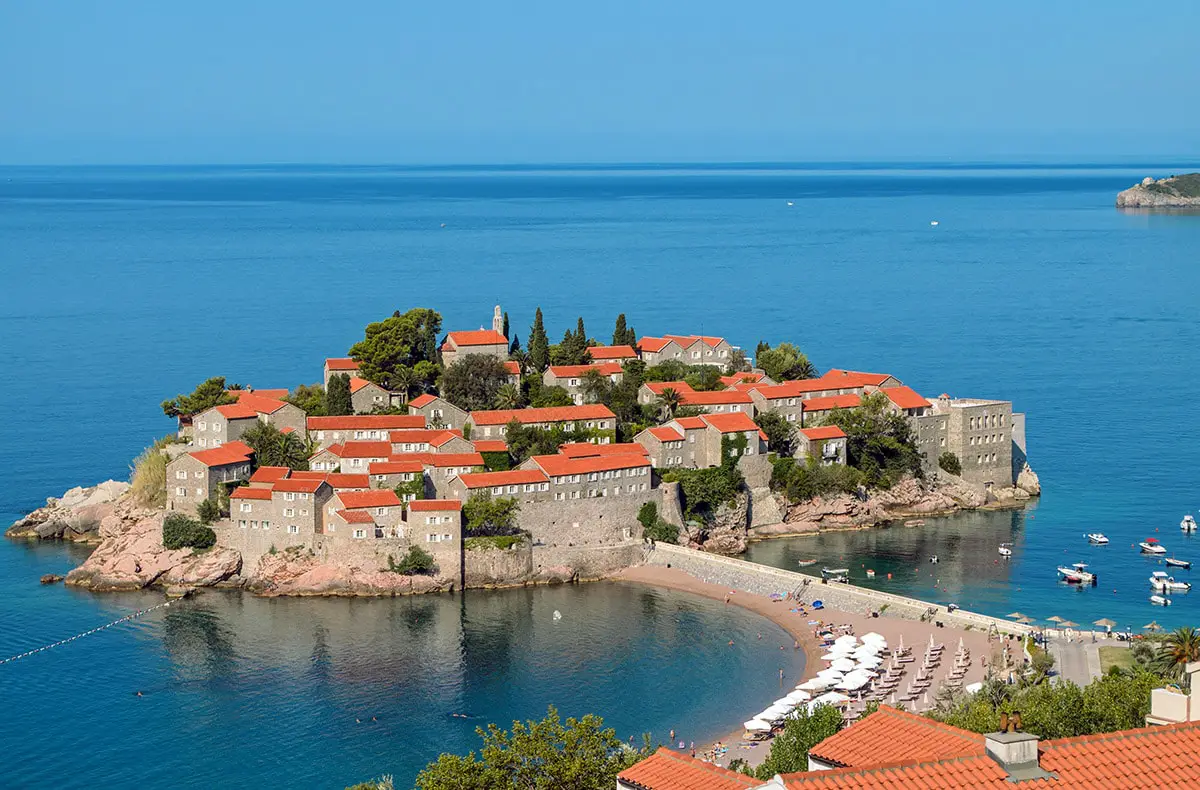
Google Maps took me on a driving adventure down very narrow lanes about 1km past the turnoff to here. But the homes were very high-end glass, flat-roofed mansions.
The entire Montenegro coast (like the rest of the Balkans) rises to high rugged limestone mountains. There was no tunnel but a long switchbacking highway to the top. I slept at a rough gravel turn out almost at the top. It was a cool (5.5°C), very windy night, but the views were breathtaking.
CETINJE
The Cetinje Historic Core is a tentative WHS: (06/07/2010). Almost all is centred between the monastery on the west end, a park, the 5 museums that are part of one ticket and the small old town on the east. I arrived at 9 am just as all the museums opened. I was alone in all of them and each had to be unlocked to allow my entrance. A woman even followed me around the Fine Arts Museum opening and then locking the door behind me. All have excellent English labels.
Cetinje was the home of the rulers and monarchy of Montenegro until 1918.
Cetinje Monastery. I again entered this tiny church during mass and the constant chant of an invisible priest. Besides all the typical icons, there was a tiny chapel to the left of the entrance with walls and ceiling covered in frescoes, a tomb, a wonderful carved wood panel and an urn.
Njegos Museum Biljarda. Njegos was the Montenegrin bishop who moved from the monastery to this palace in 1838. It was also the residence of Prince Nikola until he moved into his palace in 1867. The top floor has several small rooms of portraits, guns, furniture, a billiards table (hence the name Biljarda), traditional costumes and documents. The bottom floor has an unusual exhibit of the same artist: modern photos of exotic women wearing high fashion, several nudes and many holding a macabre severed head.
The highlight may be the large-scale relief map of Montenegro on a scale of 1:10,000. It was made in 1916 to aid the occupying Austrian army. Except for some flat land around Lake Skadar and the plateau where Podgorica is located, the entire country is rugged limestone mountains.
King Nikola’s Palace Museum. Nikola was the last ruler of Montenegro from the dynasty Petrovic Njegos (1918). It has 13 rooms of furniture and portraits.
Ethnographic Museum. Don’t miss this excellent museum with superb displays and terse labels. The costumes from the various regions of Montenegro were great.
History Museum (National Museum of Montenegro – Vladin Dom). It covers from prehistory to the Balkan War. The bombing of Dubrovnik in 1991 (with the Serbian army) was an especially dark part of Montenegro’s history. A highlight is the Icon of Our Lady of Phileremo – supposedly the oldest picture of the Virgin, it was painted by Luke the Evangelist in Jerusalem!! It has resided in Rhodes, Italy, Nice, Malta, Russia (where the metal covering was replaced with a gold one and it was adorned with precious stones – 270 diamonds, brilliants and rubies), Copenhagen, Berlin, Belgrade and since 1941 in Montenegro!!!!!
A very pleasant woman at the front desk gave me an excellent run-down of the history of Montenegro, much better than the displays within.
Fine Arts Museum. In the same building as the history museum, it showcases Montenegrin artists. I especially enjoyed the work of Vojislav Stanic.
Lipa Caves. Just 5 km SW of Cetinje accessed by a very narrow road, this cave system has some nice flowstone columns.
PODGORICA
Podgorica is the capital of Montenegro.
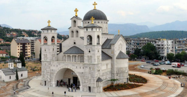
Cathedral of the Resurrection of Christ, Podgorica. Wow, what a church! The outside has about 7 metres of very rough limestone (some carved with bas-reliefs) and then finished geometric limestone above and the gorgeous brass doors with a lunette mosaic.
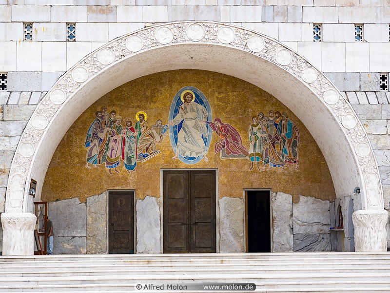
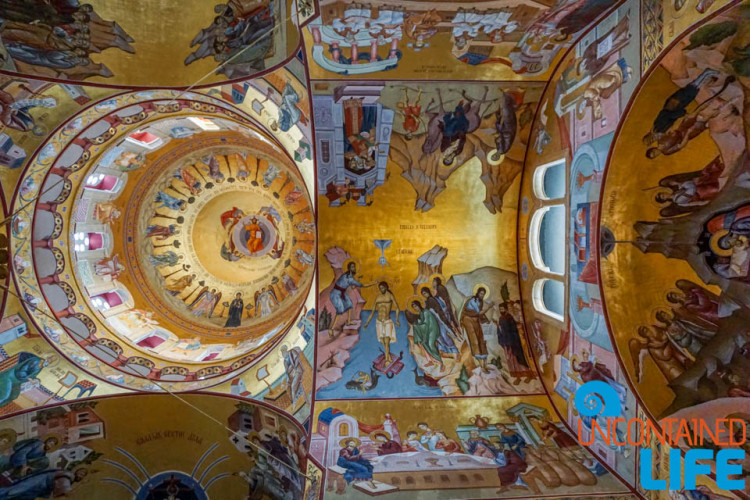
The inside is completely painted in frescoes with gold leaf backgrounds and small mosaics of the previous rulers of Montenegro. The altar has a lovely marble arch, the interior doors are either marble lattice or carved wood and the pulpit was carved white marble. The “chandelier” hanging from the dome was a big globe with a double ring of metalwork.
Doclea. A tentative WHS (06/07/2010). this Roman archaeological site is not really worth the 5km drive north of Podgorica. Few walls are over a metre high. It appears that they started to make this a nice visit with the beginnings of a paved walkway and signs in front of the various temples (it takes great imagination to visualize any), but then realized that it was a waste of time.
Church of Saint Great Martyr George and Saint Neomartys of Momisici. I was given a tour of this tiny church by the custodian who dated everything inside for me: the entrance was the 15th century, the icons 18th century and the church the 11th century. The bells hang from an unusual concrete rectangular arch separate from the church.
Skendor Charesh Mosque (Starodoganska Mosque). This tiny mosque was built in the 15th century when it was the only mosque in town. Traders took it over and it was called Starodoganska. In the 1950s, it was a city storeroom but was returned to the Islamic community in 1952. It had extensive restorations after the 1979 earthquake and again in 2008. Inside it has plain white walls and a mihrab. In rooms behind, it is now the headquarters of the Islamic community in Montenegro, the Islamic newspaper Elif, a meeting room and a library. The single minaret has an unusual 12-sided pointed spire. A gaggle of pretty girls were in the courtyard killing time between classes.
Natural History Museum. The usual stuffed animals. €1. It is about to move into new quarters as of April 10.
Dajbabe Monastery. 10 km south of Podgaric, this is the most unusual Serbian Orthodox monastery I have seen to date. Fronted by a modern rectangular shop, behind are three caves in the shape of a cross, all accessed through tiny entrances. The small cave to the left is covered in faded frescoes, the larger one to the right has better frescoes and the altar screen in the larger central cave has only 4 icons, a record low number for an orthodox church. Outside is a modern canopy with a dome of bright blue metal topped by a brass ball. It covers a rock carved in bas-reliefs.
Inside was a team of women scrubbing the place clean in preparation for a celebration on the upcoming Sunday.
Monastery Dajbabe is dedicated to the Assumption of the Virgin. It was established in 1897, and the natural shape of the cave was used as the place for the church. Later, the cave was expanded to obtain the basis form of the church, with extra chapels.
The only visible part of the church is out of the cave and it is a large porch with two bell towers. The interior of the monastery was painted by its founder, monk Simeon Popovic who adapted the scenes to the natural shape of the rock and worked on its interior until his death in 1941. He was found dead in the cave.

Lake Skadar — lies on the border of Albania and Montenegro, and is the largest lake in Southern Europe. It is named after the city of Shkodër in northern Albania. It is a karst lake.
Lake Skadar is the largest lake in the Balkan Peninsula with a surface area that seasonally fluctuates between 370 km2 to 530 km2. Lake Skadar itself is located on the western Balkan with approximately two-thirds (229 km2 of its surface belonging to Montenegro and about one-third (142 km2 to Albania. The lake’s water level also varies seasonally from 4.7 to 9.8 m above sea level. The lake extends in the NW-SE direction, and it is approximately 44 km long.
The Bojana River connects the lake with the Adriatic Sea, and the Drin River provides a link with the Ohrid Lake. The lake is a cryptodepression, filled by the river Morača and drained into the Adriatic by the 41 km long Bojana (Albanian: Buna), which forms the international border on the lower half of its length. The largest inflow is from the Morača, which provides about 62% of the lake’s water. The total drainage area is 5490 km2.
There are additionally some fresh water sources at the lake bottom. A characteristic feature of Lake Skadar’s water balance is the high inflow from a number of temporary and permanent karstic springs, some of which are sublacustrine in cryptodepressians (so-called ‘oko’). The Southern and southwestern sides of the lake are rocky, barren and steep, having bays in which the sublacustrine springs, are usually to be found.[1] On the northern side, there is an enormous inundated area, the boundaries of which change as water levels fluctuate.
Some small islands like Beška, with two churches on it and Grmožur, a former fortress and prison can be found on the southwest side of the lake.
The Montenegrin part of the lake and its surrounding area were declared a national park in 1983. The Albanian part has been designated as a Managed Nature Reserve. In 1996, by the Ramsar Convention on Wetlands, it was included in the Ramsar list of wetlands of international importance. Near the mouth of Rijeka Crnojevića, 11 m below the surface of the water there is a well-preserved wreck of the steamboat Skanderbeg sank by Partisans in 1942, during the Second World War.
The Lake Skadar system is a well-known hotspot of freshwater biodiversity and harbours a highly diverse mollusc fauna.
Lake Skadar is one of the largest bird reserves in Europe, having 270 bird species, among which are some of the last pelicans in Europe, and thus popular with birders. The lake also contains habitats of seagulls and herons.
It is abundant in fish, especially in carp, bleak and eel. Of the 34 native fish species, 7 are endemic to Lake Skadar.
Vranjina Island. In the NM “islands” series, it is hardly recognizable as an island as the water surrounding it consists of a very small muddy-banked stream on the north side of Lake Skadar. The town of Vranjina is small and decrepit looking.
Cross the rugged limestone mountains between the interior of Montenegro and the coast via the 5.1km Sozina Tunnel – €5.
BAR
The Old Town of Bar is a tentative WHS (06/07/2010).
Old Bar Fort
King Nikola’s Palace (Devora Kralja Nikola). This was King Nicola’s summer residence built in 1865 and now holds the County Museum of Bar. It has the usual: prehistory, Greeks, Romans, Middle Ages, Turks, liberation in 1878 and ethnographic exhibits from the area. It is metres from a great promenade along the lake and is surrounded by a grand park with walkways, palm trees and umbrella pines. A 2850 BC tomb is in the garden.
Church Of St. John Vladimir. Only 3 years old, this fantastic Serbian Orthodox Church is completely covered in frescoes, virtually identical to the new orthodox church in Podgorica.
ULCINJ
in the very south of Montenegro near Albania, Ulcinj and southern Albanian majority areas is in the NM “XL” series.
Ulcinj Castle
Sailors’ Mosque
