Sweden – Norrland Lapland (Luleå) July 20, 2019
When parked for the night along the water in Helsinki, a very drunk Norwegian couple from Tromso stopped by the van to talk. They had driven the 1200kms here in two days. I had not thought of seeing northern Scandinavia but changed my mind then. My original thought was to take the train from Turku and see northern Finland, Sweden and Norway but train costs were prohibitive, so I decided to drive. So from Tampere, Finland I turned north to see the following regions in order:
Finland – Northern Ostrobothnia and Eastern (Oulu)
Finland – Lapland (Rovaniemi, Ivalo)
Sweden – Norrland Lapland (Luleå)
Norway – Nord-Norge (Tromso, Narvik, Kirkenes)
Norway – Lofoten and Vesterålen
Norway – Trøndelag (Trondheim)
Sweden – Norrland East and Jämtland (Umeå, Östersund)
Sweden – Svealand (Stockholm, Örebro, Karlstad)
Sweden – Gotland (Visby)
I had already been to southern Norway and Sweden prior to my accident in September 2018, so this would complete seeing all the Nomad Mania regions in northern Europe. The plan was not to bother much with all the sights in the series, but only add to my regions. I hoped to finish it all in 10 days or less.
From Finland Lapland, I drove around the north side of the Gulf of Bothnia to Luleå. I then turned north on highway E10 to drive to northern Norway.
Hertsön Island. Hertsön is a residential area in Luleå, Sweden. It had 5,436 inhabitants in 2010, making it one of the largest districts in Luleå.
The district was built in the 1970s as part of the Million Programme, due to the planned construction of a new steel mill (Stålverk 80, a major expansion of the existing Norrbottens Järnverk steelworks), which was expected to give the city a large increase in population. As the plans of the new steel mill were binned, following the victory of the centre/right-wing coalition in the general election of 1976, there have periodically been many empty apartments in the area.
LULEÅ (pop 75,000)
This is a city on the coast of northern Sweden, and the capital of Norrbotten County, the northernmost county in Sweden. Luleå has the seventh biggest harbor in Sweden for shipping goods. It has a large steel industry and is a center for extensive research. Luleå University of Technology is one of Sweden’s three technology universities and the northernmost university in Sweden.
History. The town’s Royal charter was granted in 1621.The original town was situated where Gammelstad (Old Town) is situated today. The town had to be moved in 1649 to the current site, due to the post-glacial rebound that had made the bay too shallow for ships to enter. The Gammelstad Church Town is a UNESCO World Heritage Site.
In 1805, Luleå only had 947 inhabitants, but in 1865 Luleå succeeded Piteå as the county town in Norrbotten county and now had around 1400 residents. In the 1860s the industries also started taking root in the city.
The town has been plagued by fires in 1653, 1657 and in 1887, and the fire in 1887 was a devastating fire that destroyed most of the town, sparing only a few buildings. The Neo-Gothic Cathedral (originally the Oscar Fredrik church), dedicated in 1893, standing at 67 meters (220 ft), is the tallest building in town.
Economy. Luleå’s commerce and industry are a mix of industry, research, education, trade, and services. Major employers in the city are the SSAB steelworks and Luleå University of Technology. A Swedish Air Force wing, F 21 (or Norrbotten Air Force Wing), is stationed near Luleå at the neighbouring Luleå Airport. Other major employers include Ferruform (a subsidiary of Scania AB) and Gestamp HardTech (acquired from SSAB 2005-01-01).
IT industry. Luleå is the home of several major innovations and technological milestones.
Broadcast radio: RDS, DAB, DARC (1992–1997)
The Luleå algorithm for routing (1997)
Living Labs: leading European service testbed with 6000 users (2001–)
Marratech: pioneers in Internet-based E-meetings (1998–) – acquired by Google, releasing in November 2008 video-chat support in Gmail
On 27 October 2011, Facebook announced it would locate its first data center outside of the United States in Luleå. The whole facility is made up by a set of three 28,000 m2 (300,000 ft2) buildings. The first building was to be operational in 2012. The establishment will help turn the Luleå region into a major node for European data traffic. The town’s northern location and that it will become a hub for data traffic in Europe has generated a new epithet for the Luleå region – The Node Pole. The Node Pole region provides stable, low-cost electricity that is 100-percent derived from renewable sources. In addition, they cite the benefits of low cooling expenses, given that the region is one of the coolest in Sweden. Sweden’s long political stability is cited as another long-term benefit of the Node Pole’s location.
Facebook expands into Luleå. The new European computer center in Luleå is Facebook’s first investment outside of the US. Some of the reasons that Facebook choose Luleå were because of natural cooling due to the climate, cheap electricity, reliable electrical networks, and clean energy. The computer center is the largest in Europe, with 84,000 m2 which is comparable to 11 football fields.
The computer center will process large amounts of data through thousands of computers working as one. The establishment of Facebook in Luleå has also led to other companies realizing the potential of establishing in Luleå. The positive effect has also been noticeable at the university where the applications rate has risen with 18 percent- Luleå Science Park has also had an increase with 25 percent of new established companies.
Climate. Luleå has a subarctic climate which borders on a continental climate with short, mild to warm summers and long, cold, snowy winters.
Due to the Gulf Stream, Luleå has a warmer climate than other cities on the same latitude and even some that are further south in Canada, Alaska, Northeast China and Siberia. During the summer in June and July the temperature in Luleå can some days rise to around +30 degrees Celsius. Summers are very bright, with marginal twillight being the only exception during the summer solstice.
Museum of Norrbotten. The exhibits shows photographs and Sami crafts – both with the roots of the northern botanical nature, which offers huge expanses of mountains, forests and sea. Nature provides food, materials for crafts and inspiration for creation. Max Ekersund is 11 years old, cartoonist and gamer from Luleå. During the summer of 2019 he exhibits his drawings at the Norrbotten Museum.
Church Town of Gammelstad (Gammelstads kyrkstad) is a UNESCO World Heritage Site (1996) situated in Gammelstaden. It is the best-preserved example of a type of town that was once widespread throughout northern Scandinavia.
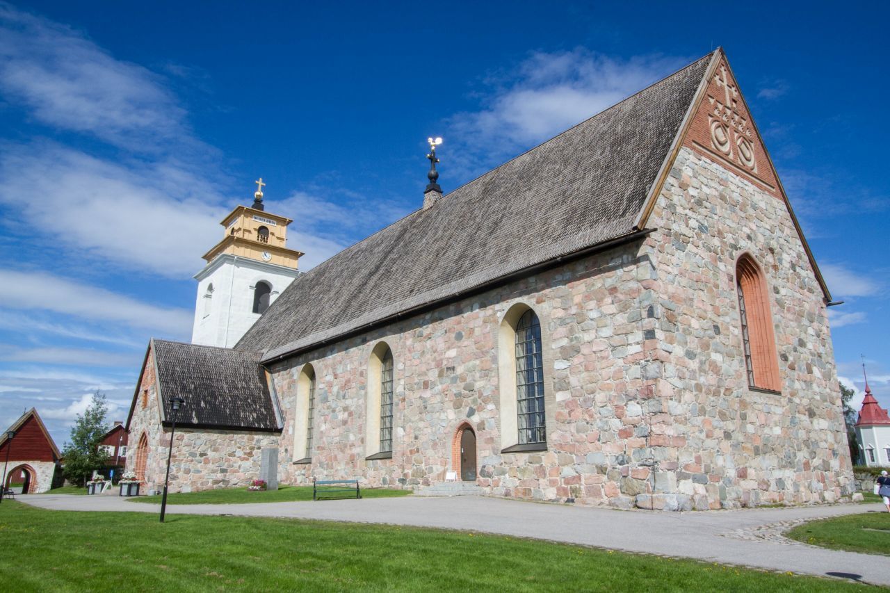
The town is located about 10 kilometers upstream of Lulea on the Lule River. At its centre is the 15th-century Nederluleå Church surrounded by 424 wood-built houses. The houses were only used on Sundays and during religious festivals to accommodate worshipers from the surrounding countryside who could not return home the same day because of the distance and difficult traveling conditions. Apart from attending church, people could relax, meet with their near and dear ones and make new acquaintances from other villages.
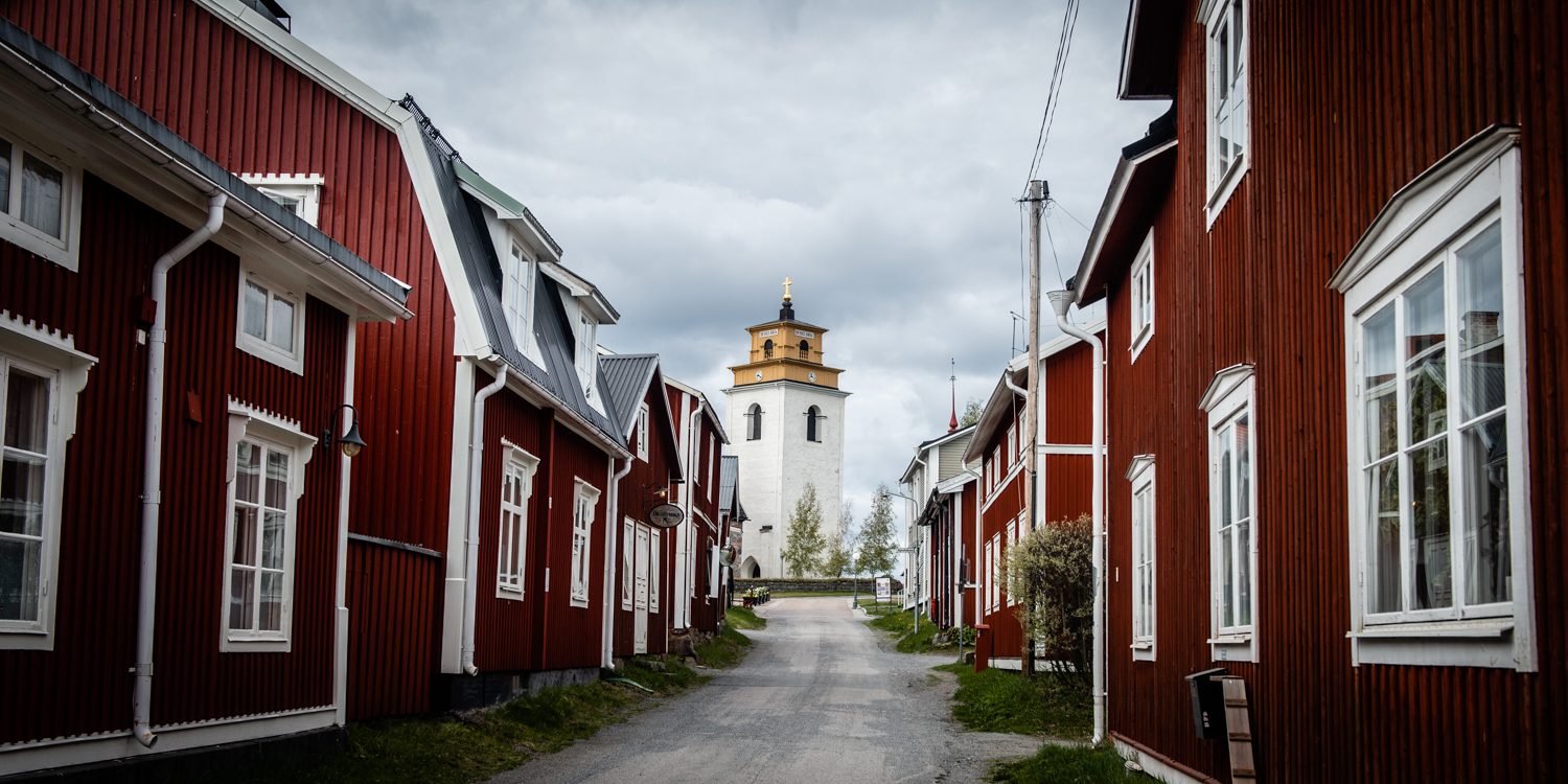
The houses are tiny red with white trim, most one-story and line all the streets. Because the buildings are built from timber, regular maintenance is required to prevent rot; surveys have been carried out to document the extent of existing rotting, and snow is cleared regularly during the winter.

Today the church cottages are privately owned just as they used to be and only used for occasional accommodation. The owners came here during church holidays, family celebrations and various events. It is still prohibited to use the cottages as permanent homes dating from the 19th century regulations. The cottages are very simple and do not have running water but most have electricity.
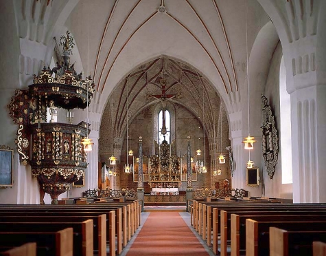
In the center is Nederlulea Church built in the latter 15th century. It is the largest and most elaborate of the churches built around then. The intricately carved gilt alar piece dates from the 1520s. The pulpit is richly carved and painted with gilt, greens and reds and it along with the ornate frames around small paintings are the highlight of the church. The apse is completely covered with faded murals and floral motifs.
I entered during Sunday service with 23 parishioners present. The town was very quiet with almost no one around. Free


From Gammelstad, I took highway E10 north, turned east on E45 and crossed back into Finland at Karesuvanto. During the 595kms drive through Sweden, I had to stop twice for naps. The Swedes are very considerate with their radar cameras by warning you a few hundred metres before of their presence. As a result I drove well over the 100km/hour speed limit.
I crossed the Arctic Circle at 2:30pm. The forest slowly turns into a boreal forest of stunted deciduous (birch and others) and conifers (pine and spruce). Low forested mountains appear but the highway was flat the whole way. Mosquitoes arrived. There are no Nomad Mania sites along the entire route.
Wildlife seen were: a young female moose (European elk), a reindeer feeding nonchalantly on the side of the road and a reindeer that trotted along the middle of the highway ignoring all the traffic stopped behind it.
Lapponia. The Laponian Area is a large mountainous wildlife area in the Lapland province in northern Sweden, more precisely in Gällivare Municipality, Arjeplog Municipality and Jokkmokk Municipality.
It was made a UNESCO World Heritage Site in 1996; the bulk of it had enjoyed protected status since the early 20th century. The area was made a heritage site for both natural and cultural reasons.
The total area is about 9,400 square kilometres (3,600 sq mi), making it the world’s largest unmodified nature area to be still cultured by natives—the natives in this case being the reindeer herding Sami people. Only parts of the area is actually used for pasture by them. With such a large space, the geography of the area varies greatly; it is dominated by mountains, rivers and lakes. Each nature reserve and national park has its distinctive features. The amount of snow in winter and rain in summer is considerable.
95% of the area is protected as national parks or nature reserves. It consists of the national parks Muddus, Sarek, Padjelanta and Stora Sjöfallet, and the nature reserves Sjaunja and Stubba. The remaining 5% are located in the areas of Sulitelma, Tjuoltadalen, and Rapadalen (part of which is in the Sarek park).
The village of Porjus is a natural point of entry to the Laponian area and has recently opened an information center.
The Laponia area also contains three major hydropower stations with belonging basins and a big expansion of 100 wind power stations inside the world heritage area is planned.
The highest mountain of the area is Sarektjåhkkå, at 2,089 metres (6,854 ft).
Laponian Area is a large mountainous wildlife area in the Lapland province in northern Sweden, more precisely in Gällivare Municipality, Arjeplog Municipality and Jokkmokk Municipality.
It was made a UNESCO World Heritage Site in 1996; the bulk of it had enjoyed protected status since the early 20th century. The area was made a heritage site for both natural and cultural reasons.
The total area is about 9,400 square kilometres (3,600 sq mi), making it the world’s largest unmodified nature area to be still cultured by natives—the natives in this case being the reindeer herding Sami people. Only parts of the area is actually used for pasture by them. With such a large space, the geography of the area varies greatly; it is dominated by mountains, rivers and lakes. Each nature reserve and national park has its distinctive features. The amount of snow in winter and rain in summer is considerable.
95% of the area is protected as national parks or nature reserves. It consists of the national parks Muddus, Sarek, Padjelanta and Stora Sjöfallet, and the nature reserves Sjaunja and Stubba. The remaining 5% are located in the areas of Sulitelma, Tjuoltadalen, and Rapadalen (part of which is in the Sarek park). The village of Porjus is a natural point of entry to the Laponian area and has recently opened an information center.
The Laponia area also contains three major hydropower stations with belonging basins and a big expansion of 100 wind power stations inside the world heritage area is planned.
The highest mountain of the area is Sarektjåhkkå, at 2,089 metres (6,854 ft).
NOMAD MANIA – Sweden
Experiences:
Experience Jokkmokk winter market
Play Brännboll
Play/hear drejelire/nyckelharpa
Railway, Metro, Funiculars, Cable Cars: Sweden Intercity Railway Experience
NOMAD MANIA Sweden – Norrland Lapland (Luleå)
World Heritage Sites:
Church Town of Gammelstad, Luleå
Laponian Area
Struve Geodetic Arc
Sights: Rapa River Delta
Islands: Hertsön
Borders:
Finland-Sweden
Norway-Sweden
Sweden (sea border/port)
XL:
Harjufjarden (Norrboten)
Inakari (Kataja)
Pello
Tornio/Haparanda
Airports: Kiruna (KRN)
Railway, Metro, Funiculars, Cable Cars
Inlandsbanan
Iron Ore Railway Line/Ofoten Line (Lulea-Kiruna-Narvik) |
Museums: Jokkmokk: Ajtte Museum
Modern Architecture Buildings: Jukkasjärvi ice hotel
World of Nature:
Padjelanta
Sarek
Ski Resorts: Riksgränsen Ski Resort
The Dark Side: Boden: Rödberget Fortress
ABISKO
Abisko National Park (Sight)
Planetariums: Abisko: Aurora Sky Station
Landscapes of the ‘Kungsleden’ trail
European Cities
LULEÅ
World Heritage Sites: Church Town of Gammelstad, Luleå
Airports: Lulea (LLA)
Museums: Luleå: Museum of Norrbotten
KIRUNA
Museums: Kiruna: Sami Museum
Religious Temples: Kiruna Church

