Azerbaijan – West – Ganja-Qazakh, Shaki-Zaqatala – November 23-24, 2019
Currency. Azerbaijan manet (AZN). Exchange rate November 2019 1€ = 1.88 AZN
Capital. Baku
Population. 10 million
GETTING IN
Visa. Most citizens of Western countries can enter with an e-visa obtained at www.evisa.gov.az. Cost for the regular, 3-day service was €20 + €3 administration fee payable by credit card on the web site.
The form asks for all the usual personal and passport information but also requires where you are staying – I booked a hotel in Baku on booking.com and canceled it at no cost. A color photo of your passport – this must be in jpg format and the size cannot exceed 1000mb. This challenged me as the scans of my passport were all in pdf format. I never take photos and it took a long time to figure out how to compress the photo down to this size. Pay the fee at the end.
There is a one-day express or the normal 3-day processing period for the above fee. I received the visa by email in 3 days. I didn’t bother printing it but simply showed the downloaded visa on my computer and that was satisfactory.
At the Border. I crossed by land from Georgia.. There is only one land crossing between the two countries in the north.
You are asked for the same things several times. First passport and e-visa. Second drivers license, car registration, passport. First wicket passport, car registration, driver’s license, e-visa again. They queried my Iran visa and visit and took a long time. Check the back and interior briefly. Second wicket: passport, car registration, drivers license. Get payment stub for Road Tax and pay across the road – US$ or € so I paid US$15 and got the receipt. Change from a $100 bill was US$70 and 24 AZN. Return and show receipt and pay for car insurance US$15 for 30 days. I paid in AZN. Final check: passport and payment stub of road tax.
Wikivoyage stated that a deposit of several thousand $ would be necessary as a carnet but there was no mention of this. They did not require my International driver’s license and did not ask to see my car insurance green card.
OBSERVATIONS
Gas Prices. The price of fuel is fixed in Azerbaijan, the same everywhere in the country. The costs are: 95 octane gas – AZN 1.50, 92 octane gas – AZN .90, LPG – AZN 65 and diesel – AZN 60. I thought Georgia’s prices (about €.71/litre) were the cheapest in Europe and the Middle East, but then I came to Azerbaijan where a litre of diesel costs AZN .60 or €.32!! Now this is cheap, but still 10X more expensive than Venezuela. Thinking that I would not find gas cheaper than Georgia, I filled up just before the Azerbaijan border. It is always a mistake for a government to subsidize gas prices.
Domesticated animals on the road. Just as in Georgia, there are dogs, many cows, geese, horses pulling carts, sheep, chickens, turkeys and even water buffalo. At least 6 herds of cows passed me as I was eating dinner on my first night. Maybe they were out for their evening stroll? One wayward cow ran down the highway in the wrong direction. I never did see the guy return.
Fences. They seem to love opaque fences as every property either has a fancy stone wall or wood fence. The stone ones are real creations – usually with cement pillars and a filling of decorative stone or brick in intricate patterns. ll
Lada cars. I have not seen this many Ladas anywhere else in Eastern Europe, not even in Ukraine. I guess that 80% of the cars are Ladas – usually with no lights. All the taxis are old beat-up Ladas.
Zaqatala Panhandle. In the NM “XL” series, this geographic area is in the far northwest of Azerbaijan surrounded by Russia to the north and Georgia to the west and south.
Foothills with rugged high mountains rise to the north (the border of Russia) – all snow-covered at the end of November. The frequent rivers are wide gravel flood plains. Flat plains stretch to the south butting against low mountains and Georgia.
SHEKI (pop 63,000)
Shaki is in northern Azerbaijan on the southern part of the Greater Caucasus mountain range, 325 km (202 mi) from Baku.
History. There are traces of large-scale settlements in Shaki dating back to more than 2700 years ago. The Sakas were an Iranian people that wandered from the north side of the Black Sea through the Derbend passage to the South Caucasus and from there to Asia Minor in the 7th century B.C.
Shaki was one of the biggest cities of the Albanian states in the 1st century. The city was ruled by Armenian Sembateans, the Kingdom of Georgia, the Atabegs of Azerbaijan and the Khwarazmian Empire, before the Mongol invasion.
Feudal era. In the early 1500s, Safavid king Ismail I (r. 1501–1524) conquered the area, it was twice under the Ottomans (1578-1603 and 1724–1735). Shaki Khanate was established in 1743, during the reign of Nader Shah with silkworm breeding, craft and trade.
Modern Era. The area was fully annexed by Russia by the Treaty of Gulistan in 1813 and the khanate was abolished in 1819. During its history, the town saw devastation many times and because of that, the oldest historic and architectural monuments currently preserved are dated to only the 16th–19th centuries.
Geography. Shaki is surrounded by snowy peaks of the Greater Caucasus, which in some places reaches 3000–3600 m.
Religion. The Albanians were early converted to Christianity by the Armenians. The Church of Kish is thought to be approximately 1,500 years old. The Khan’s Mosque, Omar Efendi Mosque and Gileili Minaret are considered important places of worship in the city.
Economy. During 1850–70, Shaki became an international silk production centre. More than 200 European companies opened offices in the city. Shaki possesses a small silk industry and relies on its agricultural sector, which produces tobacco, grapes, cattle, nuts, cereals and milk. The main production facilities of Shaki are the silk factory, gas-power plant, brick factory, wine factory, sausage factory, conserve factory, and a dairy plant with its integrated big-scale Pedigree Dairy Farm.
The city is home to the annual Mugham Festival and Silk Road International Music Festival.
Kish Church. About 6kms north of Shaki and at a high enough elevation to have snow on the ground, access this tiny stone church up a narrow cobble land hemmed in by dressed stonewalls. The church dates to the 2nd century built by the Apostle Elyse and is the oldest Armenian church in the Caucasus. It has a dome and vaulted interior with plain stone walls. Inside is an archaeology museum with an animal cult burial dating to the 4th-3rd millennium and pots and copper from the 3rd century BC. There are several storyboards about Caucasus architecture, art and a theory proposed by Thor Heyerdahl that Norwegians originated in Azerbaijan arriving in the 1st century AD. Norway was instrumental in restoring the church.
Shaki Fortress. Built by the founder of the Shaki Khanate Haji Chelebi Khan (1743–1755), the walls are close to a thousand and two hundred meters long and over two meters thick. A 5m wall surrounds the palace and many buildings inside: 2 museums, a market and a restaurant. There are no remnants of fortress buildings.
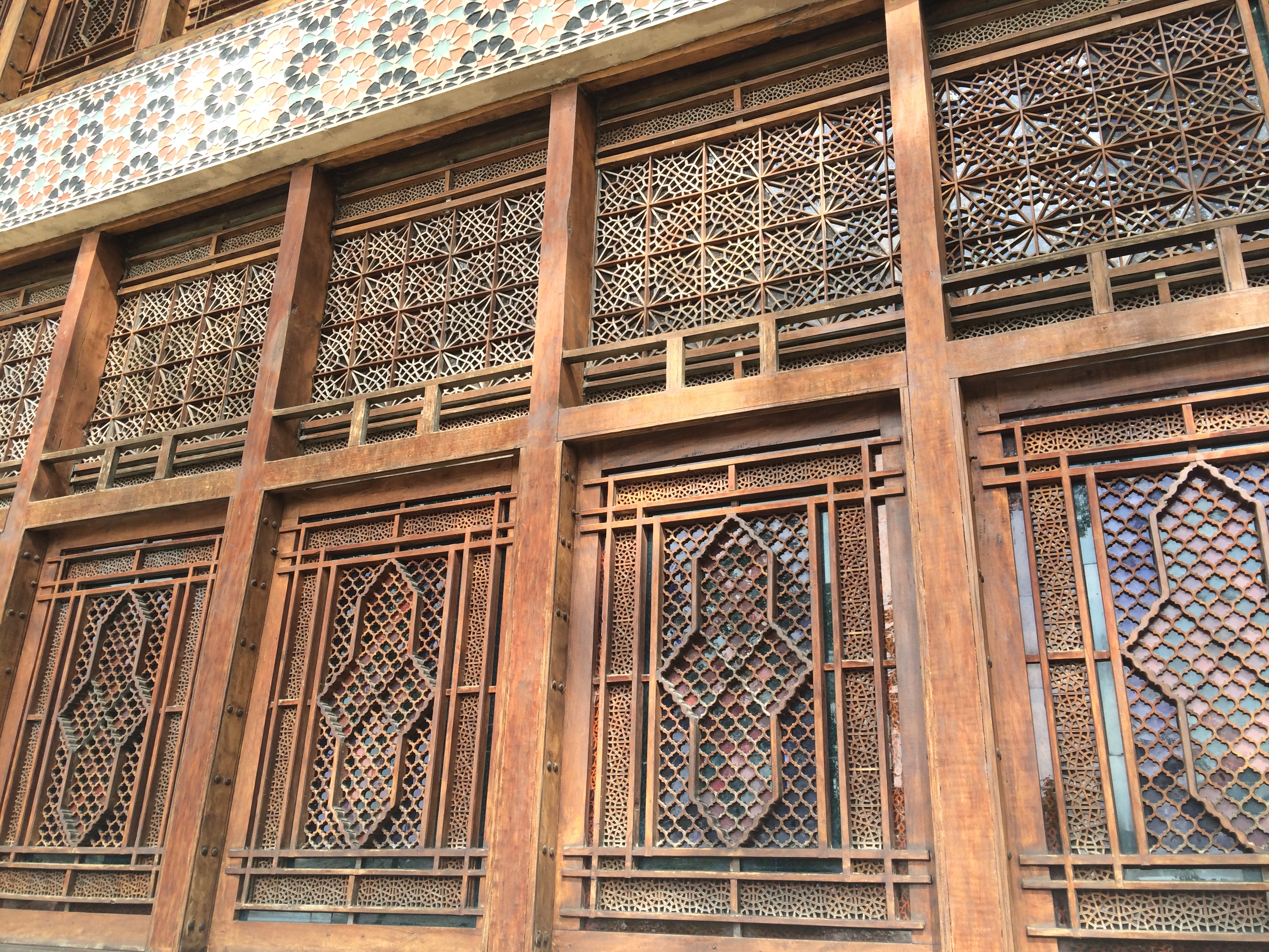
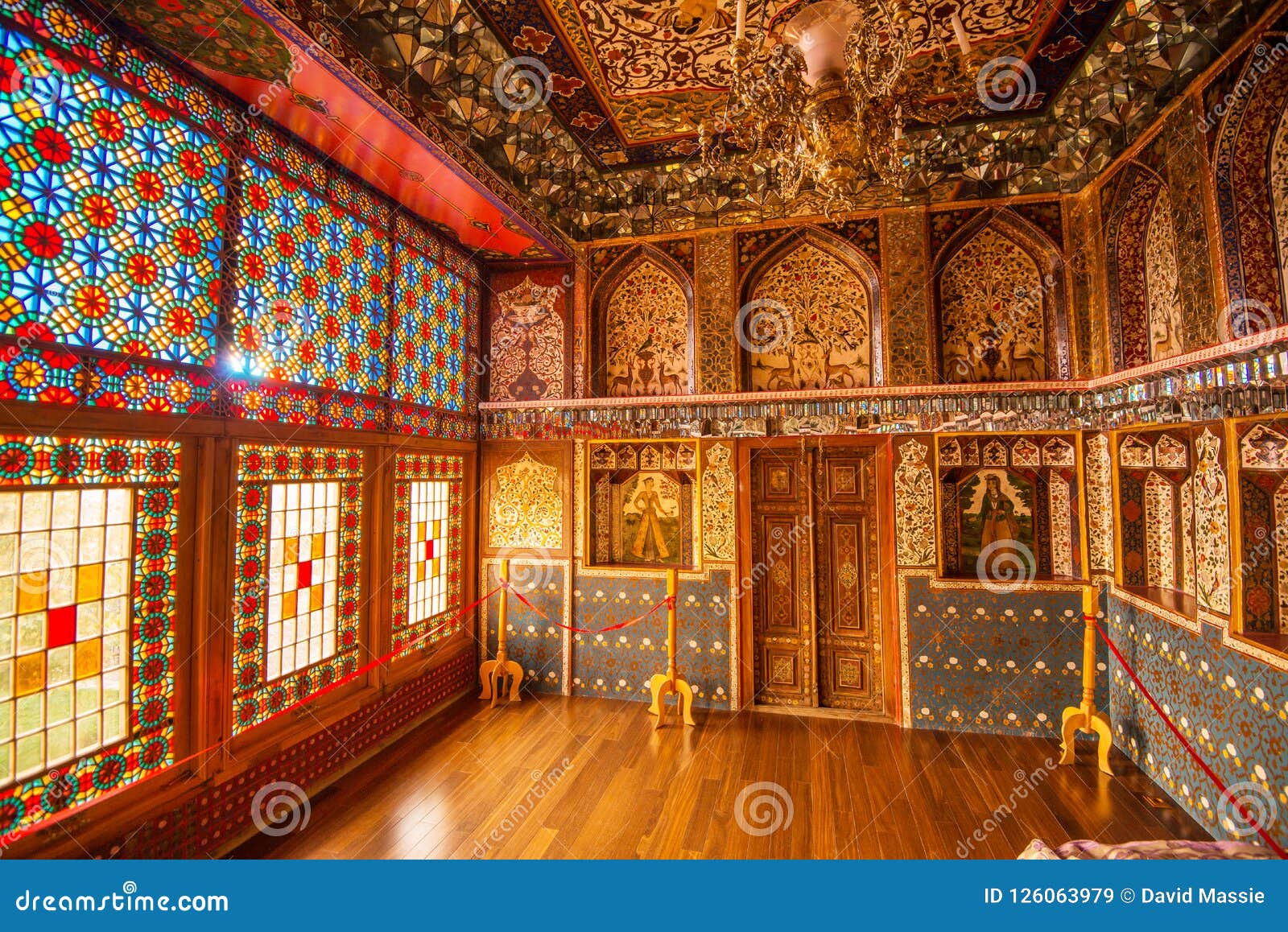
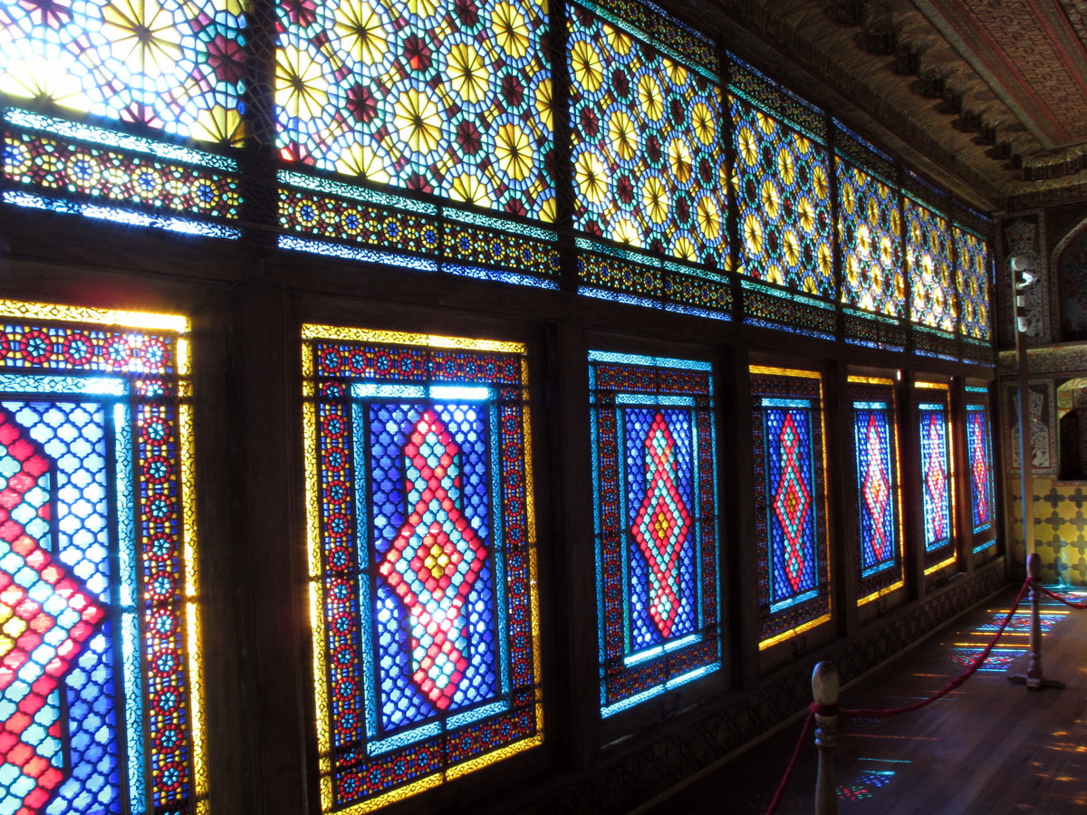
Sheki, the Khan’s Palace. This was a summer residence of Shaki Khans constructed in 1762 without a single nail. It is one of the most marvelous monuments of its epoch. Within the palace are Azerbaijani Khanate-era artifacts, as well as displays of the art scene, considered to be among the finest in the world.
A World Heritage Site (2019), this is a wonderful small palace. The outside has many intricate carved windows, tile designs and muqarnas over the doors and upper windows.

Inside is a marvel of multi-coloured stained glass in all those intricate windows. The rooms are painted in geometrics on the bottom and floral designs on the upper walls and ceilings. A line of muqarnas surrounds each room. A war scene also surrounds one room. Each room has what appears to be a tiny fireplace but these were the “air conditioning” system. AZN 5


Outside are two ancient “cinari” trees dating from 1530 – 42m high and 13.4m in circumference.
Beside the temple is the Abad Sheki Ceramics and Applied Art Center which should not be missed. The outside is adorned with spectacular tiles and small ceramic porches with figures. Inside are pots, vases and “high-rise apartments”, all with individual designs.
QABALA (Qəbələ, Gabela)
Gabaland. This theme park is 6 km north of Gabela and was closed for the season. Most of the attractions are for kids. More in the foothills, there were many high-end hotels (and more under construction). This is the high-rent district of the city.
Yeddi Gozel Waterfall. About 10 km northeast of Gabala, the last 3 km are rough rock. Then climb up about 130 steps to get to see it. Not that impressive at this time of the year.

I then had a long 3+ hour drive to Baku. The road followed the base of the foothills. The deciduous forests had lost most of their leaves and with no undergrowth, the sidelight spilling through the trees in the afternoon was gorgeous. The road then climbed over two sets of hills with about 4-5 cm of snow on the ground before coming down to the very wide coastal plain before the Caspian Sea.
GO TO Azerbaijan East (Baku)
I returned to Western Azerbaijan on November 27, driving directly from south of Baku on the coast. The road crosses a completely flat semi-desert.
GANJA (332,000)
Ganja is Azerbaijan’s third-largest city. It was named Elisabethpol in the Russian Empire period. The city regained its original name, Ganja, in 1920 but was changed again in 1935 to Kirovabad but in 1989, it returned to Ganja.
History. It was founded in 859-60. Historically an important city of the South Caucasus, Ganja has been part of the Sassanid Empire, Great Seljuk Empire, Kingdom of Georgia, Atabegs of Azerbaijan, Khwarezmid Empire, Il-Khans, Timurids, Qara Qoyunlu, Ak Koyunlu, the Safavid, the Afsharid, the Zand and the Qajar empires of Persia/Iran. Ganja is also the birthplace of the famous poet Nizami Ganjavi.
Ganja is 400–450m above sea level in the northeastern foothills of the Lesser Caucasus mountain ranges on the Ganjachay River, 375 km (33 mi) away from Baku. Ganja has a semi-arid climate (Köppen climate classification: BSk).
The city has about 33,000 Azerbaijani refugees from Armenia and IDPs from the Azerbaijani community of Nagorno-Karabakh and surrounding areas.
Religion. The majority of the Muslims are Shia Muslims (Azerbaijan has the second highest Shia population percentage in the world after Iran.
Economy. Partially agricultural, and partially tourist, nearby mines produce copper and alumina and there are porcelain, silk and footwear industries. Other industries process food, grapes and cotton from the surrounding farmlands.
The city has one of the largest textile conglomerates in Azerbaijan and is famous for a fabric named Ganja silk.
Juma Mosque. Located in the centre of Ganja, the mosque was built in 1606. It is also often called “Shah Abbas Mosque” because it was built on the instructions of Shah Abbas the Great during his reign.
In 1776, two minarets were attached to the mosque and are now part of a separate elaborate brick building (the original mosque?). They have unusual wrought iron tops and one is leaning. The mosque was built of red brick, which was traditional for Ganja. A madrasah functioned at the mosque for a long time, where the eminent Azerbaijani poet and scientist Mirza Shafi Vazeh taught.

In 2008, it was reconstructed. Old Russian bonds put into an envelope had been found during the reconstruction. This finding helped to conclude that the last construction works had been in 1910, not at the end of the 18th century, during the Javad Khan’s reign, as it was considered earlier.
The main building is one large square covered by a huge single dome with a band of Koranic script. The few stained glass windows are lovely.
Museum of Local History (Ganja State History-Ethnography Museum). Has the usual archaeology, history and ethnographic exhibits. Labels have zero English always reducing the value of these museums. AZN 5
Bottle House. This unusual 2-story private residence is built using 48,000 glass bottles of different shapes and sizes, and colourful stones brought from Sochi by Ibrahim Jafarov, a resident of Ganja in 1966-67. The construction was dedicated to the memory of Ibrahim Jafarov’s brother who went missing during World War II.
The walls of the house are decorated with the construction year, notes about the Olympic Games held in the USSR in the 1980s, and the name and portrait of the owner. The words “Ganja” (the historic name of the city) are written on the different parts of the building with the bottoms of bottles, however, during that time, the city was officially called Kirovabad (1935-1989).
The façade and balcony of the house are mostly tiny stones with intricate designs of circles and triangles with black and some green bottles forming designs on a large section of the north wall. Tiny brown bottles are used for most of the writing. Vases using multi-coloured tiles line the balcony.

The interior that I didn’t see.
The house was reconstructed recently with a new wood roof and portraits of missing brother Yusif Jafarov are on one wall and under the eves. It is a popular destination for citizens and tourists.
