Armenia – Gegharkunik, Lori, Shirak, Tavush (Gyumri) November 29, 2019
OBSERVATIONS
1. Currency. Armenian Dram – AMD. Exchange rate (Nov 2019): 529 AMD = 1€.
2. Drivers. Easily the worst thing about Armenia is the aggressive drivers. Of the “accelerate hard, brake hard” variety, they use every opportunity to get ahead – drive on the wrong side, speed, cut ahead, drive on the shoulders and use constant lane changes. Beware if you drive here as the danger of an accident is high, especially when changing lanes. I have never been passed so often. In my five days, I saw 4 significant accidents.
Some of their other bad habits are unsafe passing on hills and corners, cutting corners, excessive speed and extreme intolerance.
I still have not figured out who has the right of way in roundabouts.
3. Cost of diesel. It averages 430 AMD/l = €.81, about .08€ more than Georgia but well over double the cost in Azerbaijan. Gasoline is cheaper. Most cars seem to run on LPG and these gas stations are the most common.
4. Demographics. Russian is the most common language. English skills are virtually absent. Almost all belong to the Armenian Apostolic Church and tend to be a religious lot.
5. Alphabet is an ancient script similar to Georgia and is indecipherable. All these countries with impossible, isolated scripts (Georgia, Armenia, Greece, Montenegro), are poor. Having to learn 3 alphabets in school (including Latin and Cyrillic) has to make education hard. Access to the world’s literature must be limited. National pride can only go so far.
6. Museums. Most are closed on Mondays. Relatively cheap (the most expensive are less than €4, several are free and some about €.50, but most are missable. A few of the exceptions:
Yerevan: 2nd floor National Museum, Cafesjian Center for the Arts (Free), Folk Art Museum, Sergei Parajanov Museum (great house, wonderful art), Levon’s Divine Underground (not really a museum but shouldn’t be missed).
Gyumri: Gallery of Maryan and Eranuhi Aslamazyan Sisters (very good temporary exhibit), Museum of National Architecture and Urban Life
GETTING IN by CAR
VISA. A 21-day tourist visa is available on arrival at the border. Don’t get into the car line for the wickets but stop at the first building and buy the visa. 3-day transit – 10,000 AMD, 21-day tourist – 3000 AMD, 120-day tourist – 15,000 AMD. Payable in cash (AMD) or by credit card (+300 AMD processing). There was an ATM next to the visa wicket. Withdraw AMD for the additional expenses to come.
Of course, I got into the car line and had to drive back and buy the visa. Get a stamp on the visa itself. Car registration, driver’s license.
Customs and Ecology Tax. 9,600 AMD payable in cash.
Vehicle Declaration. Present the receipt from the Customs and Ecology tax declare the vehicle value and give the home address. Keep the form to present on departure from Armenia. Free
Vehicle Insurance. There are several brokers after leaving the immigration area. 18,000 AMD for 10 days. This is quite expensive.
ALAVERDI
MONASTERIES of HAGHPAT and SANAHIN World Heritage Site
Queen Khosrovanush of Armenia, wife of King Ashot Bagratuni (r. 953-977) was a patron of both these monasteries. Both were built in honour of her sons Smbat and Gurgen, later kings of Armenia and Lori respectively. Their image holding a model of the churches is carved on the walls of each. In the 11th century, 500 people were living in the Monasteries of Haghabat and Sanahin, both with prominent theologians, scholars and teachers.
Haghpat Monastery Complex. Haghbat is at the top of the mountain 3.5 km off the highway. It has dramatic vistas.
Built between the 10th and 13th centuries, there were 3 churches, an academy, a scriptorium for copying and illustrating manuscripts and an extensive library with religious, philosophical, historical and scientific texts. Many flat grave slabs are in the front yard and gavit (narthex) and there is a mausoleum with 3 chambers to the side. Khachkars (ornately carved cross-stones) are in the yard.
Church of the Holy Sign. The main church, St Nshan (“Holy Sign”) was built in 976-991. The outside façade has several crosses and inscriptions. Enter the gavit (narthex) with vaulting and huge cross ribs. The main church has a central dome and cross shape, is plain grey stone with faded murals on one sidewall and is better in the apse. There are chambers on the 2nd story in all four corners.
Her son’s images are carved under the east gable holding a model of the church. The wall paintings are of Christ and a princely donor.

Church of St Grigor
Church of St Astvatsatsine
Hamazasp (refectory or dining hall). Has 2 great domes,

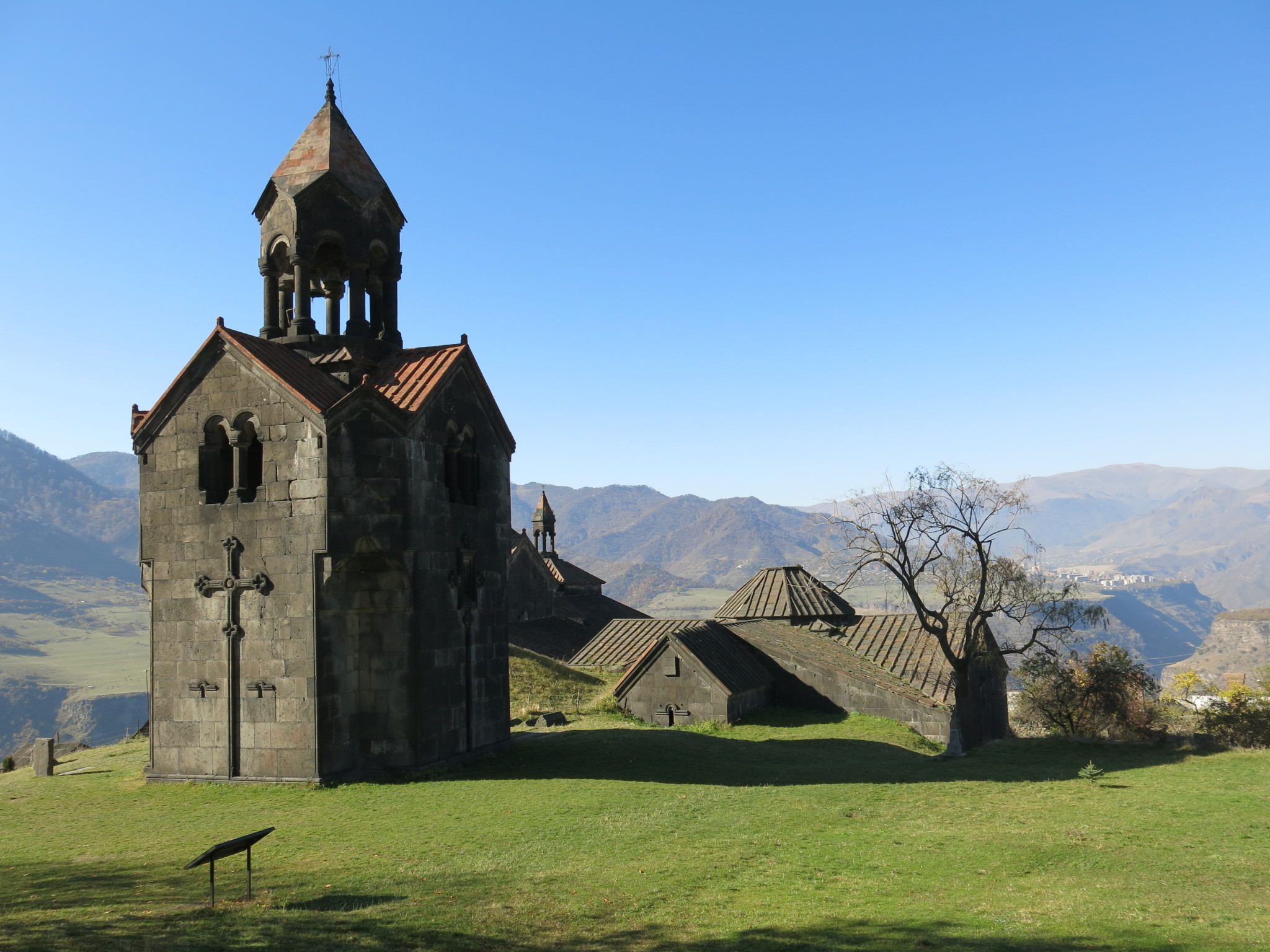
Belfry (bell tower). Separate at the back, it has wonderful bas-relief crosses, and maqarnas designs in outside corners. Beside it is a nice gravestone with a woman picking grapes.
Sanahin Monastery
Drive 4.8 km off the highway to this monastery in a “suburb” of Alaverdi, high above the town.
Church of the Redeemer. Dated to 966, it was designed by Trdat who built the cathedral of Ani, the capital of Medieval Armenia known as the city of one thousand and one churches.
Unusually the church has two gavits or narthexes, the first with 3 naves and vaulted ceilings and a second with a central dome supported by 4 grand columns with Gordian knot capitals with vases on the corners. The floors of both narthexes are almost entirely grave slabs.

The church is a simple square cross with a high dome. No paintings have survived. The image of her sons on the back outside wall is much more ornate than the one at Haghpat. Below on the wall are bas-relief columns with ornate capitals.
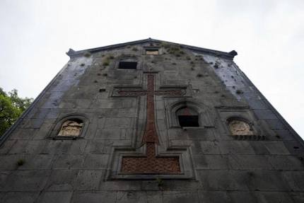
Bell tower. Connected to the corner of the first narthex, it is 3 stories with a lovely, large, stone-inset red cross on the front and 2 small ones in the back.
Church of St Gregory the Illuminator. Built between 1061-63 by Queen Hranush, this round church has a unique system of ceiling arches to support the heavy stone vaulting plus a library. It was closed and appears to be used for services.
Mausoleum for the Zakarid and Kiurkean families is in a separate building.
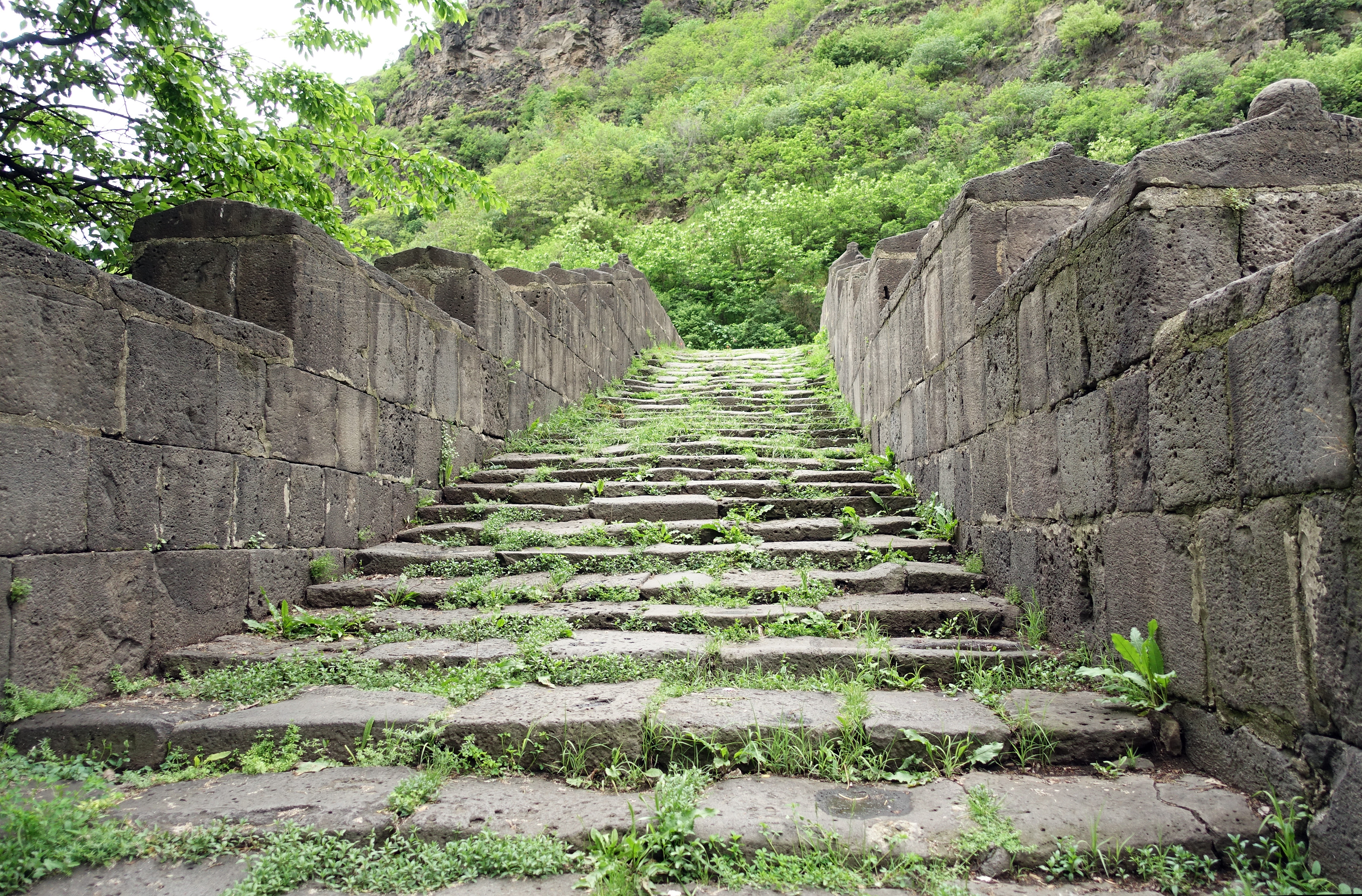
Sanahin Bridge, Alaverdi. Crossing the Debed River, this is a great old stone bridge with massive end piers, a single arch 18.6m across and stone at least ⅔ of a meter wide forming the sides. It was built in 1192-2000 on the old way from Sanahin to Alaverdi by Queen Venani, the wife of King Abas III. Walk up the 3m wide stairs past side stones with knobs and several lions as decorations to the flat bridge deck. Stairs leave from the opposite side.

Debed Canyon National Park. 25 km north of Vanadzor the canyon cuts a steep rocky gorge. Rich in history and culture, Debed Canyon is one of the most attractive sites in Armenia. Lacking tourist facilities, visitors usually stay in Vanadzor and take day trips to the stunning canyon. On the way, you can choose to visit the UNESCO World Heritage-listed Sanahin and Haghpat monasteries, together with countless little villages along the Debed River. The area is home to several fascinating khachkars – impressive cross-stones that are the perfect reflection of medieval Christian Armenian traditional art.
VANADZOR (pop 82,000)
Vanadzor is the third-largest city in Armenia serving as the capital of Lori Province in the northern part of the country. It is located about 128 kilometres (80 miles) north of the capital Yerevan. As of the 2011 census, the city had a population of 86,199, down from 148,876 reported at the 1979 official census.
Vanadzor, along with Gyumri and Spitak (25 km (16 mi) west), suffered a considerable amount of damage from the 1988 earthquake when 564 residents died in the city. Unlike the two other cities, the majority of buildings in Vanadzor were unscathed from the earthquake
At an average height of 1,350 metres (4,430 feet) above sea level, Vanadzor is located in the valley of the Pambak River, at the point where the rivers of Tandzut and Vanadzor join the Pambak River. The city is surrounded by the over 2,500-metre-high (8,200-foot) mountains of Bazum and Pambak. The southern and eastern regions are densely forested while to the north and west are only covered with bushes and plants. The climate of Vanadzor is characterized by cool summers and relatively mild winters.
The population of Kirovakan-Vanadzor increased significantly after World War II when Stalin allowed open immigration to the Armenian Soviet Socialist Republic with the promise of a better life for the arriving Armenians in the historical homeland. More than 150,000 Armenians from different parts of Europe and the Middle East, most being survivors of the Armenian Genocide, immigrated and settled in Kirovakan. Due to the harsh conditions imposed by the Soviet intelligence and the Ministry of Interior, many of the immigrants were sent to labour camps in Siberia and elsewhere. The reason for such disrespectful treatment towards the Armenian immigrants was that almost all were more educated than the local community, spoke more than 3 languages, and were open followers of the Armenian Apostolic Church, something that was considered a threat to the national security by the Stalinist Government. Despite the difficulties, more Western Armenians immigrated to Kirovakan during the following years. However, many of the immigrants left the city and returned to their diaspora countries, including Cyprus, Lebanon, Syria, Greece, France and the United States.
The city of Vanadzor is the main industrial centre of the province. The industry of the city is quite diversified with many firms specializing in garment manufacturing, chemical products, building materials, and dairy products.
Museum of Fine Arts. In a lovely 3-story curved building, it displays local artists. AMD 500
Usually called Armenian Switzerland or Little Switzerland by the locals, it is one of the most important resorts of Armenia, situated within the Dilijan National Park. The forested and reclusive town is home to numerous Armenian artists, composers, and filmmakers and features some traditional Armenian architecture. The Sharambeyan street in the centre has been preserved and maintained as an “old town”, complete with craftsman’s workshops, a gallery and a museum. Hiking, mountain biking, and picnicking are common recreational activities.
Dilijan lies on the Aghstev River at 1,500 metres (4,921 feet) above sea level. The valley is surrounded by the Lesser Caucasus mountains from the north, and the Semyonovka mountain pass from the south. The mountainous areas -mainly the ranges of Bazum and Pambak mountains- are all covered with thick forests. Reaching the highest peaks of the mountains, the forests turn into Alpine meadows. The climate in Dilijan is cool during summer and cold with snowfalls in winter.
Lake Parz is one of Dilijan’s most attractive natural sites. It is situated in the northern part of the town with an area of 2 hectares.
Dilijan is famous for its mineral water, being processed and bottled by the “Dilijan Mineral Water Plant” founded in 1947. Dilijan is also famous for its hand-made rugs and carpets.
Regional Museum and Art Gallery. Local history, archaeology, ethnography and local traditional art. The building was originally a residential house dating back to the second half of the 19th century. AMD 500
Haghartsin Monastery. From the highway north of Dilijan, drive 5.8 km up through a lovely forest to this monastery nestled in a small valley. The monastery was completely renovated in 2011. Ancient weathered grave slabs are scattered around the buildings.
Refectory. 13th century, it has photos from before the restoration, huge cross rib vaults and two lovely domes.
St. Gregory the Illuminator Church. From the 10th century, it is a small square design with the apse entered through a massive stone wall.
St. Astvatsatsin Church. From the 11th century, it appears to be used regularly. The narthex has no ceiling but four columns and two arches remaining.
St. Stephanos Church. 12th century, tiny.
On the hill above the monastery are several sepulchres and gravestones. One is in the middle of a small roundabout.
Dilijan National Park. The forests of Dilijan cover an area of more than 34,000 hectares. Formed in 2002, woods cover 94% of the park territory and with around 40 types of trees and 18 types of bushes, mostly oaks, beeches, hornbeams, maples, elms, willows, etc. The national park is also rich in its fauna, including brown bear, wolf, marten, otter, lynx, sylvan cat, Persian squirrel, sylvan dormouse, hedgehog, chamois, European red deer, wild hog, pheasant, quail, partridge, Caspian turkey, culver, bald eagle, lammergeyer, pygmy eagles, golden eagle, hawk and others.
SEVAN (pop 19,000)
One of the most popular resorts in Armenia, it is on the northwestern shores of Lake Sevan at 1,925 metres (6,316 feet) above sea level, 65 km (40 mi) northeast of the capital Yerevan. Sevan is surrounded by the Sevan National Park.
The Sevan peninsula, located 3 kilometres (2 miles) east of present-day Sevan, is home to one of the most notable samples of medieval Armenian architecture, the Sevanavank Monastery of the 9th century. Initially, the monastery was built at the southern shore of a small island, that later turned into a peninsula during the 1st half of the 20th century, as a result of the artificial draining of Lake Sevan under Joseph Stalin’s rule, causing the water level to fall around 20 meters.
The climate of Sevan is characterized by short mild summers and long, cold, and snowy winters. Despite its southern location, due to elevation and continentality, a climate of Sevan is similar to Eastern Finland.
During the brief summer of the region, Sevan turns into a popular beach resort. Many professionals and amateurs visit the city to practice their favourite types of sports on the shores including beach soccer, beach volleyball, windsurfing and other types of water sports through numerous swimming beaches and facilities along the entire Sevan shore, such as the water park, the horse-riding club, the tennis courts, the mini football and basketball fields, etc.
In February 2011, the Sevan ropeway was opened in the north of the town, in the area known as “mashtotsner”, on the way to Tsovagyugh village. It has a length of 1,130 meters. Sevan is among the 3 towns of Armenia that are allowed to accommodate gambling houses and activities in urban settlements (along with Tsaghkadzor and Jermuk).
Sevanavank Monastery. This sits on the high hill at the tip of the Sevan Peninsula that juts into Sevan Lake. Park and climb the 220 steps to the monastery.
Gregor Lusavorich (Gregory the Illuminator) established a hermitage and St Harutiun Church on top of a pagan temple here in 305. It was destroyed in an earthquake in 995. Princess Miriam, wife of Prince Vasek Gabir, had two churches built on the hill in 874. Both were pillaged by the Mongols and Timurids but were revived as monasteries in 1441 and a seminary in 1451. The Chitaghian Brothers started a hermitage (St Astvatsatsin) in 1661. A monastery school existed again from 1869-80 and was again revived in the 1990s as the Vazgenyan Theological Academy (down below at the road). It has been a major center of calligraphy for Armenian manuscripts. There are now two churches on the summit. They were renovated in 1956-7. Both were locked when I was there and don’t appear to open often. The 1486 carved door is in the State Museum in Yerevan.
St. Araklats (Holy Apostle). Has a gavit (narthex).
St. Astvatsatsin (Holy Mother of God). A small domed church with 3 apses.
Sevan National Park. Founded in 1978 to protect Lake Sevan and the surrounding areas. Sevan Lake and its vicinity are rich in avifauna with up to 267 bird species recorded. The Lake’s avifauna faced a significant decline after lowering the water level and drying the Gilli marshes.
Masrik River and its tributaries are spawning places for such endemic species as Sevan trout, Sevan koghak and Gokcha barbel (Barbus goktschaicus). The young fish of these species also live in these rivers till one year of age.
The flora of the park is presented by 28 species of trees, 42 species of bushes, 866 perennial herbs and 307 species of annual and biennial plants.
Stunning Lake Sevan is one of Armenia’s natural gems and is the nearest ocean equivalent for this land-locked country. Located 1,905 meters (6,250 ft.) above sea level, this incredible freshwater lake is one of the world’s largest high-altitude lakes.
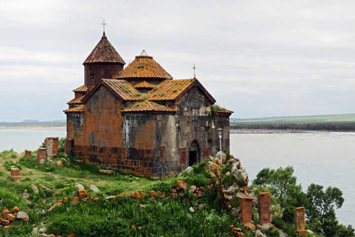
Hayravank Monastery, Hayravank. This 9th to 12th-century Armenian monastery is on the southwest shores of Lake Sevan. The monastic complex consists of a church, chapel, and gavit. Surrounding the monastery are numerous khachkars and gravestones that are part of a small cemetery.
The church at Hayravank was built during the late 9th century. It has four semi-circular apses that intersect to support the octagonal drum and conical dome. The original drum and dome had collapsed completely and were restored between 1977 and 1989.
The gavit has two thick columns to support large arches and the cupola consists of a short octagonal drum (only seen from the interior) as well as a short octagonal conical dome above decorated with “Harlequin Patterned” stonemasonry. The pattern alternates with reddish and a lighter grayish colored tufa. This example is considered to be one of the earliest examples of polychrome decorative masonry that was to become widespread in the following centuries in sacred buildings throughout Armenia. An oculus at the peak of the dome lets light into the room below.
GO TO Armenia – Yerevan, Ararat, Kotayk, Aragatsotn, Armavir
After seeing Nagorno, southern Armenia and sights north of Yerevan, I returned to northern Armenia on December 4, 2019.
Spitak (pop 121,000). In the NM “The Dark Side” series, this town 96kms north of Yerevan, was destroyed in the devastating 1988, 7.0 Richter-scale earthquake whose epicenter was at Spitak. More than 21,000 residences were destroyed and 25,000 in the region were killed. Thousands more were injured and hundreds of thousands were left homeless. It was rebuilt in a slightly different location. A stagnant economy and failed government promises have hindered many to rebuild their lives. The city lost half its population. The Spitak region has the country’s highest poverty rate at 46%. Semi-ruined housing remains and only 5,628 apartments have been rebuilt by the government and 20,770 by international foundations. Many still live in shanties assembled from scrap metal and other scavenged materials (called domiks).
House Museum of Minas Avetisyan, Jajur. (1928-1975). Born in Jajur, he moved to Yerevan in 1960. He is a painter of Armenian landscapes, some portraits and folk scenes. I didn’t particularly enjoy much of the art, although a few were OK – “Cutting Beet”. The glass in two doors was painted in abstracts. A small room had personal letters, documents and photos with other artists including Maritros Saran. He was also a set designer for ballets in the national theatre. He died in a car accident. Free
GYUMRI
Coming into Gyumrii, I was caught in the moat incredible traffic jam with nobody moving. Armenians (with their complete inability to follow rules) were at their worst here. Cars and semi-trailers parked on the wrong side of the street, cars trying to bypass and blocking things up more, then an ambulance trying to get through the other way. A sign said Bavra Customs Point. I never did figure out what was the issue.
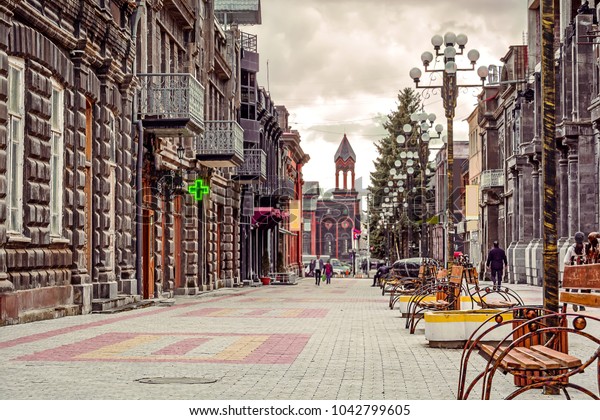
Kumayri Historic District. It is characterized by grand black (and some orange) tuff stone buildings embellished with columns, vases and decorative friezes. Most of the stone blocks are large and have a face.
Mher Mkrtchyan Museum. Mher Mkrtchyan (nicknamed Frunzik) (1930-1993) was an actor and director famous for comical movies and theatre. He won the prestigious People’s Artist of the USSR award in 1984 and is regarded as the most famous and internationally recognized Armenian artist of the 2nd half of the 20th century. On the 2nd floor of a house, see many photographs of movies and his family, costumes he wore, and some personal items (the bed was incredibly small). Free
Gallery of Maryan and Eranuhi Aslamazyan Sisters. For both artists, most of the exhibit is on Maryan (1907-98) with paintings and ceramics in bold palettes – still lifes, flowers and her travels in Africa and India. Eranuhi (1910-2006) used less subdued colours.
The temporary exhibit on the first floor was of three Armenian artists living in France and Italy. I loved all the art – Jean Carzou, Edgar Chahine and Jean Jansem. 300 AMD
Holy Mother of God Cathedral (Cathedral of the “Holy Martyrs”). A new octagonal orange stone church, it has marble wainscoting and white walls with lovely arches supporting the 8-side dome (8 windows). The altar is ornate white marble.
Museum of National Architecture and Urban Life. On the second floor of a lovely black tuff with orange accents, this is a well-organized museum with good English general descriptions and no labels (you don’t need any). The exhibits are some art, a great diorama of the city, metal jewelry making, blacksmiths, tinsmiths, copper, foundry, carpentry, stone masons, shoe and hat making, embroidery, lace, rugs and musical instruments. Then enter the home of a wealthy citizen. 1000 AMD
Mother Armenia. Built in 1975 on a hill on the west side of Gyumi, this huge statue of Mother Armenia sits on an equally tall stone base. She is bare-breasted with a long robe blowing behind her. It features the victories of the Armenians, namely the Soviet victory in the Second World War. The proudly standing Armenian woman statue symbolizes the victory holding wheat spikes in her hand. The monument is made of bronze and is the biggest monument in Gyumri.

A WWII Memorial (1941-45) is set on the hill. It has a nice clenched fist in a pool.
Sev Berd (Black Fortress). Built in response to the Russo-Turkish War of 182801829, this round Russian imperial fortress on the next hill from Mother Armenia has 15m-high black tuff walls. It was locked but a man opened it. It is now a lovely hotel with all the rooms facing the center enclosed by a roof of steel girders with a skylight. A large round stage sits in the middle of the enclosure. Free
Not far north of Gyumri, I hit snow. I tried to go to Lake Arpi National Park but was stopped by terrible roads and hard-packed snow. So I turned around and after driving on some badly potholed roads, finally hit Highway U1 (Yerevan-Bavra) which had slush some snow and more potholes. Just past Bavra was the Armenia/Georgia border. There were no issues.
