Nagorno Karabakh December 2-3, 2019
GETTING IN
From the south shore of Lake Sevan on basically snowless roads, I drove through a NM “XL” series sight – Vardenis area (East of Lake Sevan). On my way to Nagorno Karabakh (Artsakh, the road climbed up over a pass in low, grass-covered mountains, hit slush and then packed ice at the pass. The map said this was the border of Nagorno-Karabakh. There was only slush for possibly a kilometre and then dry roads. Pass a sign “Welcome to Artsakh“ and then descend multiple switchbacks to the valley floor and Artsakh immigration.
Fill out a form, show the vehicle registration and get the permit, a full page for your passport plus a registration letter that needs to be left on departure. All Free. The border guards were extremely friendly.
The highway descended the long canyon with nice rock walls that narrowed to a gorge about 20m across. There was both a tank monument and a tank ruin.
Gandzasar Monastery, Vank (“vank” in Armenian means monastery)
Legend states that the monastery was built on the remains of John the Baptist. His head was given to the prince and he buried it in Gandzak and then built the church over it. It is now surrounded by a reconstructed wall with a gate on each side.

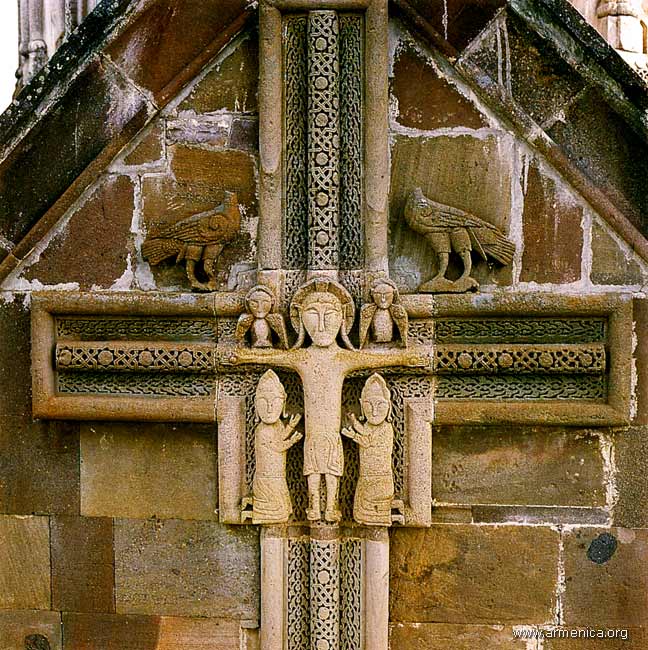
St John the Baptist church was built in 1216-38 and sponsored by the Prince of Khachen Jalal-Dola. A cross-domed church, the highlight is the exterior multi-faceted drum of the dome with carvings of Adam and Eve, the Virgin Mary with Christ, Christ, two kneeling saints, two church warders with miniatures of churches (one round) in their hands, sculptural bullheads and an eagle with outstretched wings. With only 1 slit window in each of the three apses and 4 tiny windows in the dome, it was very dark inside and I could see little detail. A man arrived and turned on the 6 sconce lights. One wall is completely inscribed in Armenian. The elevated front apse has an altar of two great stones and the front is carved in intricate geometrics.
Narthex. Built from 1261-68, the roof is supported by intersecting arches, a pair of columns and pilasters. The central square part of the arch has a stalactite shape with a skylight and 6 coloured tiles. A cross is incised on part of the dome. The west entrance has a magnificent visor with rich carvings of two birds and the north entrance has two lions. The only light comes from the skylight so is also dark and little detail could be seen until the lights here were also turned on.

From 1400-1816, it was the residence of Aghvan Catholicos with a seminary, a rich collection of manuscripts, and the family tomb of Khachen princes.
Also here is the Mesrop Mashtots Matenadaran-Gandzasar Scientific Cultural Centre, an impressive new stone structure but not open on Mondays.
It is 13 km off the main highway and a 3km drive from the valley floor to the top of Gandzasar Mountain.
Askeran Fortress (Mayraberd Fortress), Askeran. This fortress appears to be on both sides of the river. The main fortress is on the north side with intact walls and round towers except at the bottom where the highway goes through. Across the river is a small fort on a pimple of a hill with a double wall extending down the hill towards the other side. It has several round towers.
We are the Mountains Monument. Sitting on a small hill next to the highway just north of Spepanakert, this red stone block sculpture is of a bearded man’s and woman’s head. Widely known as Tatik-Papik (grandmother-grandfather), it represents an elderly Karchakhion couple in national costumes who stand shoulder to shoulder, proudly and unshakably with a steadfast gaze. It symbolizes the centenarians of Artsakh (Artsakh leads the world in the number of people over 100 years old in the world) and the bloody ties of the Artsakh people with their roots to the land. It is the only monument to centenarians in the world and is on the coat of arms of the Artsakh Republic.
Constructed in 1967, it was opposed by the Soviet Azerbaijan government, but they went ahead anyway. It has become the main tourist site in the republic.

SPEPANAKERT
Artsakh State Museum. The main exhibit “Azerbaijan as Enemy of Civilization” is before and after photographs of destroyed Armenian monuments (mostly churches). The Soviets had an active campaign of eliminating religious sites. Azerbaijan continued and destroyed many churches at a time when the number of mosques was increasing. Free
Also in the museum are the usual archaeology and ethnology exhibits.
Fallen Soldiers Museum. About the 1984-94 Nagorno-Azerbaijan war, it is mainly photographs and some mementos of soldiers killed in the war. Zero English. By donation.
SHUSHA
Susha historical and architectural reserve. A tentative WHS (24/10/2001), mainly consists of the fortress.
Shusha Fortress, Shusha, High above Spepanakert to the west, this white limestone fortress with its long wall and round towers looks impressive but only consists of that wall. Besides one derelict building, I could see nothing inside the walls. Free

I then continued to the west to leave Nagorno and reenter southern Armenia. Although I thought I had climbed as high as I could, the road continued to climb through dense fog. This road was full of potholes. When I swerved to miss one, I hit the high shoulder of the highway and bent the rim of the right front wheel. It started to leak and the low tire pressure light came on. None of the gas stations had a pump and as the pressure wasn’t decreasing, I continued to Goris in southern Armenia. I luckily stopped at a service station with a tire shop. After removing the wheel, he discovered the bent rim, took a sledgehammer to it and fixed it. All for less than €4.
