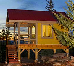
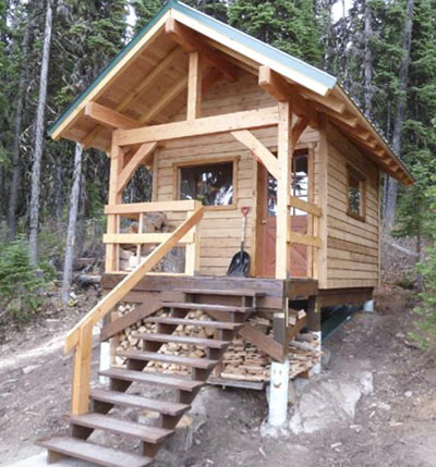
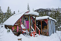
The Rossland Range provides the best backcountry skiing in the West Kootenay. There have always been several “cabins” distributed all over the range. These were built by enterprising guys over decades. Many were simple A-frames sheeted in plastic, but all had a stove to heat up your sandwiches wrapped in tin foil.
Slowly those rustic cabins are being replaced (see below for the ones still slated for replacement). The new cabins are day-use only, but equipped with wood stoves
Despite being wildly popular in the winter, they are much less visited as summer destinations. But there is no reason that they could not be a worthwhile summer trip – usually pleasant walks through forest arriving at views as summits are approached.
As these are normally winter ski or snowshoe trips, descriptions may require some imagination to use them in the summer. This description is for a half-day summer hike for each group of cabins – the Mt Lepsoe and the Mt Crowe groups. Do both loops to make it a full day. The trailheads are opposite each other at Strawberry Pass.
Drive: Drive to the top of Nancy Greene Summit on Highway 3B, also called Strawberry Pass.
From Rossland (junction of Highways 22 and 3B opposite the Rossland Museum), drive 19.8kms north on Hwy 3B.
From Castlegar, drive west on Highway 3 towards Christina Lake and Grand Forks. At the Nancy Greene Lake, turn left (south) on Highway 3B. Drive 8.4kms.
The trailheads for each of these two loops are opposite each other at Strawberry Pass – Lepsoe Loop south and Crowe Loop to the north.
MOUNT LEPSOE CABINS
A clockwise loop hike that visits four cabins and has some nice views.
Rating: ♦♦◊◊◊
Location: Part of the large trail network north of Rossland east of Highway 3B.
Difficulty: B1 Moderate
Elevation Gain: +334m
Key Elevations:
Distance: 7.3kms
Time: 3 hours
Season: Mid-June to October
Access: Excellent. 2WD low clearance off Highway 3B, a year-round paved highway. Trailhead is south of Strawberry Pass.
Map: https://www.rosslandrange.org/RRRS/Docs/MAP%20121316.pdf —- printable map
Route/Trail:
Leaving the trailhead, turn left to follow the Seven Summits Trail that goes around the gravel pit. 10 minutes through the woods takes you to Booty’s Cabin {UTM 0435102 / 5450142 — N49° 12′ 02.30″ W117° 53′ 27.13″}. This was built in 2017 to replace the Surprise Cabin. It was designed to be large enough to deal with school groups – 23′ X 14′ including the deck, or 18 X 14′ on the inside. The stairs on the front are full-width so that they can act as bleachers. As it is so accessible, it has a road to more easily deal with outhouse waste.
Continue on the Seven Summits Trail as it continues through the woods. At 1km, cross a road and switchbacks through a replanted clear-cut with open views to Mount Crowe and White Owl Pass.
Eagle’s Nest Cabin {* UTM 0435493 / 5449720 — N49° 11′ 48.77″ W117° 53′ 07.58″}. 1.5 km from the trailhead. Good views over Highway 3B to the Columbia Valley beyond.
Continue on the Seven Summits Trail as it follows a ridge on switchbacks beneath Mount Lepsoe.
Sunspot Cabin {UTM 0434675 / 5449386 — N49° 11′ 37.65″ W117° 53′ 47.79″}. At 3km at a major junction with Lepsoe Road, the cabin is just across the road.

Lepsoe Basin Cabin {UTM 0434361 / 5448699 — N49° 11′ 15.29″. W117° 54′ 02.90″}. Continue up Lepsoe Road through Lepsoe Basin. Turn up into a clear-cut full of ski trails and reach the cabin at 4.1 km.

Return: To complete the loop, return down Lepsoe Road past the Sunspot Cabin. Look for a marked turn at the big bend in the road (6kms from the TH).
Old Growth Trail. The most impressive tree is a massive cedar. Cross a road and arrive at the end at a gravel pit. Circle back to the trailhead.
MOUNT CROWE CABINS
This scenic loop sees four cabins on the slopes of Mt Crowe. Uncommon summer destinations, make for a pleasant forest walk ending at lovely viewpoints.
Rating: ♦♦◊◊◊
Location: Part of the large trail network north of Rossland east of Highway 3B.
Difficulty: A1 Easy
Elevation Gain: +299m
Key Elevations:
Distance: 13.3kms loop
Time: 3-4 hours
Season for Hiking: Mid-June to October
Access: Excellent. 2WD low clearance off Highway 3B, a year-round paved highway. Trail head north of Strawberry Pass.
Map: https://www.rosslandrange.org/RRRS/Docs/MAP%20121316.pdf —- printable map
Route/Trail: A scenic tour of 4 cabins north of Highway 3B in the Rossland Range, circling beneath the slopes of Mount Crowe. Easy snowshoeing or cross-country skiing in the winter.
Heading up the wide, well-graded trail (mainly old logging roads), take left junctions to stay on the biggest loop. As you near Chimo Cabin, the trail steepens to a long steady climb. Chimo Cabin {UTM 0433398 / 5451788 —N49° 12′ 54.94″. W117° 54′ 52.31″} is perched on a low ridge with a big view of Old Glory Mountain rising behind Mount Lepsoe.
Leaving Chimo cabin, continue along the trail taking left junctions. The forest will eventually break away into wide clear-cuts with big views to the west. Heading into the forest, follow a logging road and stay on the main network of trails when the road switchbacks higher. As you ascend, watch for a spur to Viewpoint Cabin.
Viewpoint Cabin {UTM 0434314 / 5454278 —- N49° 14′ 15.90″. W117° 54′ 08.51″} is the furthest shelter, about 2 hours from the parking area and a good lunch spot.
Viewpoint Cabin is surrounded by regenerating forest and doesn’t have a huge open view, but it does sport a beautifully painted door by local artist Jenny Baille.
Continue left up the road and enter the clear-cut again. This is the “high road” and the start to head home.
Mosquito Cabin {UTM 0434833 / 5452247 — N49° 13′ 10.35″. W117° 53′ 41.65″} is reached at the end of the clearcut at the intersection of several trails.
Head downhill through the forest about 1km to the Red Dog Cabin {UTM 0434214 / 5451602 — N49° 12′ 49.23″ W117° 54″ 11.87″} in the trees. This is an older cabin but is usually very popular due to its short distance from the parking area.
Head down the logging road where you started the hike, a short walk down to the highway.
Cookie Jar Cabin. Detour on the left to visit this historic cabin. It’s one of the oldest cabins and has been closed to visitors. However, Friends of Rossland Range plans to maintain it as a historic site.

Cabins not visited in the above tours * all to be removed or replaced.
Barking Spider* UTM 0435154 / 5448943 — N49° 11′ 23.49″. W117° 53′ 23.87″
Not so secret* UTM 0435803 / 5447578 — N49° 10′ 39.54″. W117° 52′ 51.02″
Igloo* UTM 0435242 / 5446163 — N49° 09′ 53.51″. W117° 53′ 17.91″
