
Tourism is facilitated like no other country in the world. Every town has an i-site visitor information center where any trip or means of transportation can be arranged. Speaking English and having a similar culture makes for easy travel. The bus system goes most places but a car would be ideal. Hitchhiking is safe and a great way to meet native Kiwis. The spectacular government website doc.gov.nz manages all bookings for the 55+ treks. Once registered, one can pick all the campsites or huts you want to use, pay the fees, and get a printed copy that serves as your permit. Cancellations appear as soon as available and so for the busiest booked treks (Milford Trek books out in a few days in early July), one still has a good chance of obtaining a spot. The NZ$ was relatively cheap.
Coromandel Peninsula. I hitchhiked to the north tip, seeing a pod of killer whales just offshore.
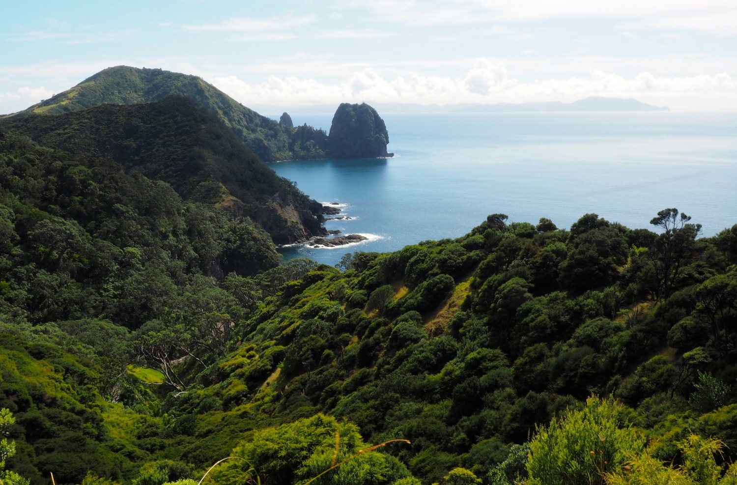
Coromandel Coastal Walkway is a scenic, 3-hour hike between Fletcher Bay and Stoney Bay. It had great coastal views and an ambling section across farmland. A shuttle is needed.
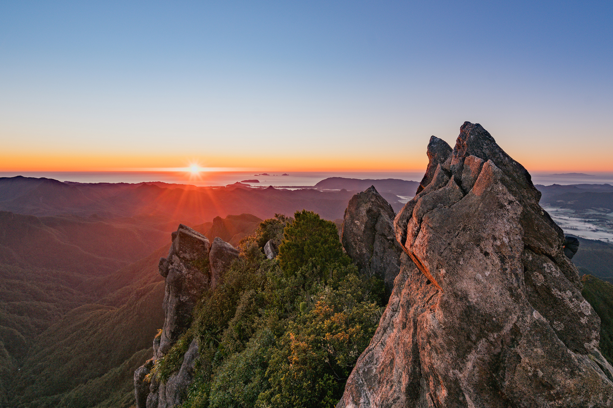
Pinnacles (759m) is a great hike in the Kauaeranga Valley behind the village of Thames. At the huge 80-bed Pinnacles Hut, I talked to the caretaker who planted the seed for me to walk the Camino de Santiago starting in Le Puy, France 1600km to Santiago. After taking a trail and stairs to the top of the Pinnacles, there were commanding views including one down to the ocean to the east.

TONGARIRO NORTHERN CIRCUIT. This was my first Great Walk. Tongariro National Park was established in 1887, as NZ’s first NP. It has 3 huge volcanoes.
The circuit is a three-day, 50 km trek that circumnavigates Mt Ngauruhoe (Mt Doom in Lord of the Rings). I skipped the traditional start at Whakapapa Village and began at Mangatepopo car park. This is the start of the Tongariro Alpine Crossing, the best and most popular day hike in the world and the first day of the Crossing. It is notorious for its weather and my first day was no different with freezing wind.

I didn’t climb the perfectly symmetrical Ngauruhoe as we were in dense fog at the bottom. Spectacular sights include South, Central and Red Crater, several brilliantly coloured lakes (Emerald, Blue and Tama Lakes), springs, cones, lava flows and glacial valleys. I stayed in Ketetahi and Waihohonu Huts to finish the circuit in three days. Access is from Taupo.
LAKE WAIKAREMOANA TREK. In Te Urewera NP, this is another Great Walk, a 46 km trek that starts by climbing from Onepoto up the spectacular Panekiri Bluff, high above the lake. The walk follows the ridge through an old-growth beech forest with gnarled trees dripping with moss.
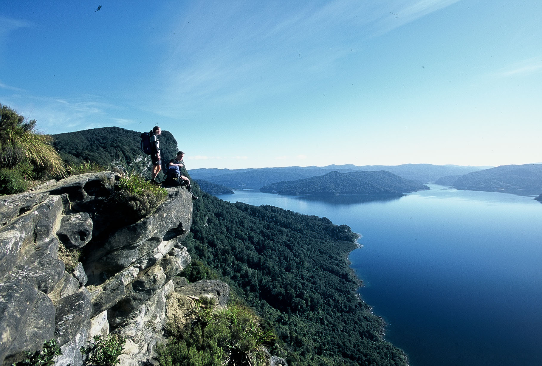
 The Panekiri Hut was perched on the edge and was a cool night. After 3 more days and two huts, I descended the ridge and walked around the lake. I was picked up on Christmas Eve and had a wonderful New Zealand Christmas with my driver and his Maori family.
• New Zealand Christmas. To do the Lake Waikaremoana Trek in Te Urewera NP, there is no public transport from Wairoa to the beginning and one has to hire a private shuttle. I was picked on Christmas Eve by the same Maori fellow.
I hit it off with him and before the trek, we went to a friend’s for some ganja, and then to his home to help load a truck with all the garbage accumulated over a few years. 40 years old, he had recently married a woman with 6 kids, there was a 9-month-old crawling around in diapers and she looked like she was ready to pop another any day.
After driving the 50 km back down to Wairoa to dump the garbage, we went to a sheep ranch to get the Christmas mutton. The dogs were amazing to watch bring in the sheep, 50 fat ones were cut out and with some difficulty, we moved them to one pen and then moved six into the killing pen. Each move seemed to take hours as the sheep freaked at all these big people trying to get them moving. The sheep wrangler, whose main command to the dogs was “fuck off boss” said each move would have taken a few minutes using the dogs. They eventually killed and butchered 4 sheep, something I had never seen before.
Then next AM, I was driven to the start of the Waikaremoana Track and returned on Christmas Eve. He picked me up and I slept on some grass in front of his rural home. His large extended family came on Christmas Day. For Xmas dinner, he had prepared a hangi, a traditional Maori meal cooked over stones in baskets under leaves – it was my best Xmas dinner since being on the road. After sleeping on his front lawn, he drove me back to Wairoa.
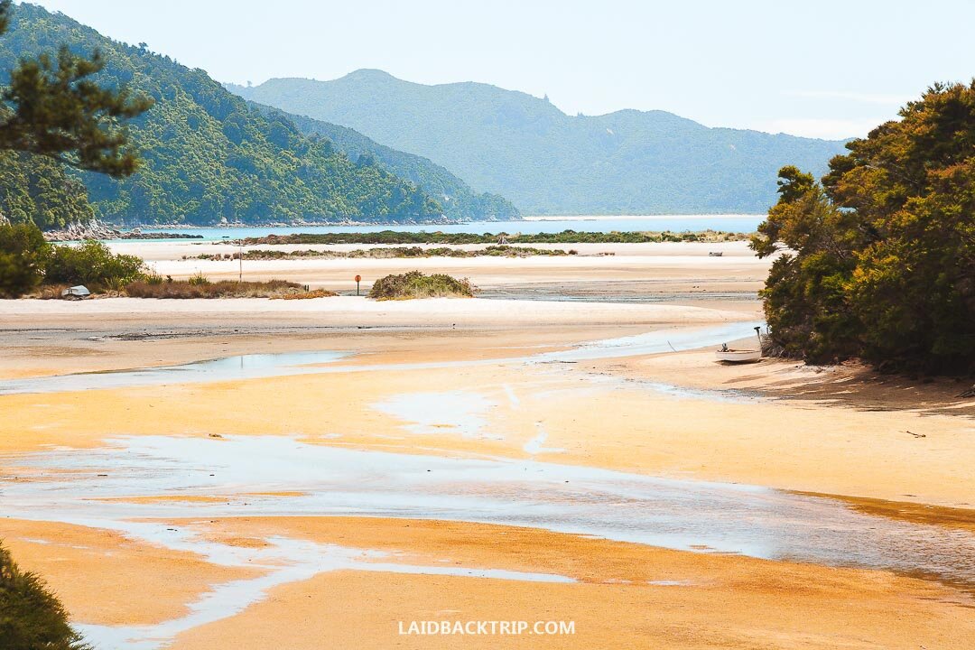
ABEL TASMAN COAST TRACK, Motueka (pop 4,000) is the jumping-off point for this 51km trek, possibly the most popular of all the Great Walks. From the start in Marahau, every permutation and combination of water taxi, kayaking and day hiking is possible in this over-commercialized park. There were at least 15 kayak tour companies. This is the only tramp I camped on so carried a tent, sleeping pad and stove. Avoiding the crowded huts and some camping areas for isolated beach camping was worth it. This was a walk in the woods with occasional hiking on a beach. We swam every day in the cold ocean.
On the first two days, I passed hundreds of day hikers and my second campsite was an unloading beach for day hikers. After I set up my tent, 75-day hikers walked in front of my tent. With 6m tides, some planning is necessary to negotiate 2 sections where the only route is the beach at low tide. Recommended beaches for camping are Te Pukatea Bay, Tonga Quarry, Awaroa Bay, and Mutton Cove, the last possible camp to do Separation Point and catch the shuttle at the Wainui car park.

I mailed my tent and thermarest back to my cousin in Auckland as I planned on staying in huts for the rest of my treks.
Farewell Spit. Between the Abel Tasman and my next great walk, I hitchhiked to this renowned bird sanctuary with 26 km of beaches, dunes, sea lions, and rock islets on the north shore of the South Island. I did a tremendous 3-hour hike along the spit, across the dunes to Fossil Point and then along the cliffs to Wharariki Beach. This hike was at the limit of flip-flops.
HEAPHY TRACK This 82 km trek crosses the mountains ending on a spectacular walk along the ocean. Taking 4 days, I stayed in the Perry Saddle Hut (climbed Mt Perry for sunrise and great views of Farewell Spit and Taranaki), James McKay Hut (can see 20 km down to the ocean from the hut) and Heaphy Hut. Add a fifth day by staying in the Saxon hut between Perry and McKay.
Day 4. The last 17 km along the wild west coast just inside a mature nikau palm forest was one of the highlights of NZ. On this last day, I met Josh, a 20-year-old from Colorado and a true freegan. Everything he had, including his food and all his clothes was found in a dumpster. He offered me the $20 he had made on the beach for juggling, stating “It’s way more fun with no money”.

Fox and Franz Josef Glaciers. Nowhere else do glaciers come so close to the ocean. This is because of the endless rain on the west coast. High up the snow falls in the glacier’s broad accumulation zone. The steep glaciers move at an astonishing pace. A plane that crashed into Franz Josef in 1943, 3.5km from the terminal face, made it down to the bottom 6 ½ years later, an average of 1.5m/day. These towns get heavy tourist traffic as all the city types want a glacier experience. Guided walks with some ice climbing and heli-hikes are hot tickets.
Mt Fox. Having walked on tons of glaciers, I opted for this vertical, gruelling hike only for masochists. Views of the Fox Glacier are rarely had because of all the clouds.
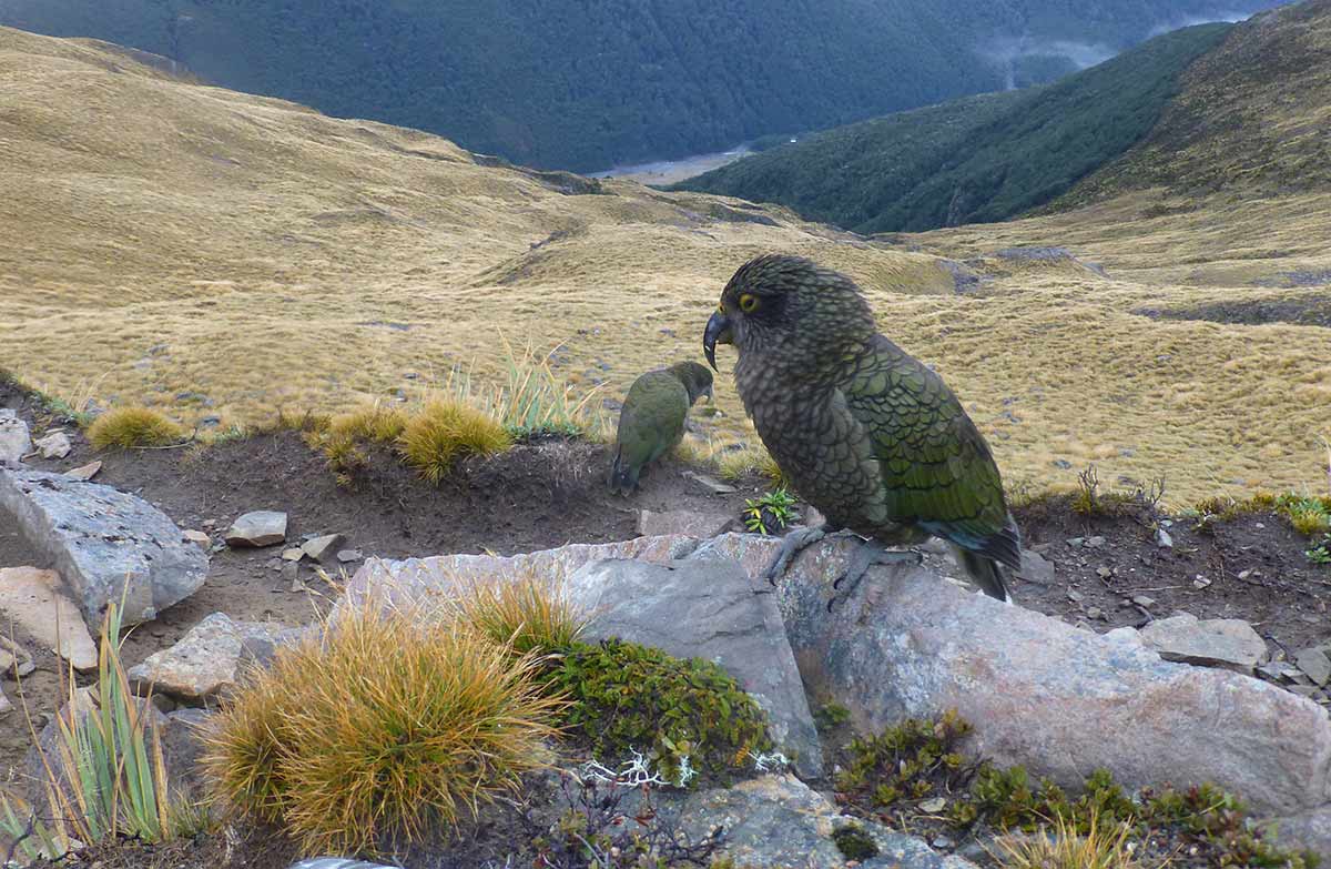
Avalanche Peak. I took the train from Greymouth to access this great day hike. Arthur’s Pass (pop 64), at 924m is NZ’s highest altitude settlement. Avalanche Peak has panoramic alpine views making it the premier day hike on the south island. A flock of keas, the only alpine parrot in the world keep you amused – one stole my plastic lunch box and dropped it off a cliff.
ROUTEBURN is a 3-day, 32.1 km Great Walk popular as it leaves the trees for the alpine. Queenstown is the access point and I mailed my travel pack to the hostel in Te Anau so that I would not have to backtrack.
Day 1. The Routeburn Falls Hut (no camping allowed) has tremendous views below a series of falls and gorges with great swimming.
Day 2. On the second day, I was hiking before sunrise in the cool, to get over Harris Saddle and climb Conical Hill, with its panoramic views down to Harris Lake, the Hollyford Valley, Darran Mountains and the Tasman Sea.
Day 3. On the third day, from Lake Mackenzie to the divide, passes the 80m Earland Falls and climbs Key Summit.

KEPLER TRACK is a 60.1 km loop that begins in Te Anau.
Day 1. Many skip the walk from town to the control gates and the 4 kilometres along the lake by taking the $25 water taxi across Lake Te Anau to Brod Bay. The first hut, Luxmore, has enormous views of Lake Te Anau and beyond.
Day 2. The second day follows an exposed ridge with top-of-the-world views all day ending in a knee-crunching descent.
Day 3. The walk out on the third day is in trees with many trampers bypassing the Moturau Hut and catching the shuttle at Rainbow Reach, 11 km from the control gates.

MILFORD TRACK This 53.5 km trek is billed as the greatest walk in the world. I wouldn’t go that far but it is a wonderful trek and has the continuously best scenery of any great walk.
Camping is not allowed and all 40 people move together each day sleeping in huts. People book this in July so most were older, more likely to be Kiwi or American, less experienced and this was their only tramp. It is expensive with total fees of $270 to cover the bus trip from Te Anau to Te Anau Downs and the boat trip to the end of Lake Te Anau, $45/night for 3 huts and the boat ride at the end from Sandfly Point to Milford Sound.
Day 1. The first day includes the bus and boat ride and it is only an hour’s walk to the Clinton Hut.
Day 2. The second day follows the Clinton River (clear green water with fish and eels) through a sheer-walled valley, a few permanent waterfalls, and hundreds of dry watercourses hinting at what this place must be like in a rainstorm. Rocky glacier-scoured granite knobs and peaks had small clinging glaciers.
Day 3 is the alpine day over MacKinnon Pass. After big views of the surrounding peaks, the trail descends beside a mountain creek with multiple waterfalls and pools. A must is the 1-hour detour to the huge 580 m high Sutherland Falls, the highest waterfall in NZ. Day 4. The last day follows the river passing several pretty waterfalls before catching the boat.
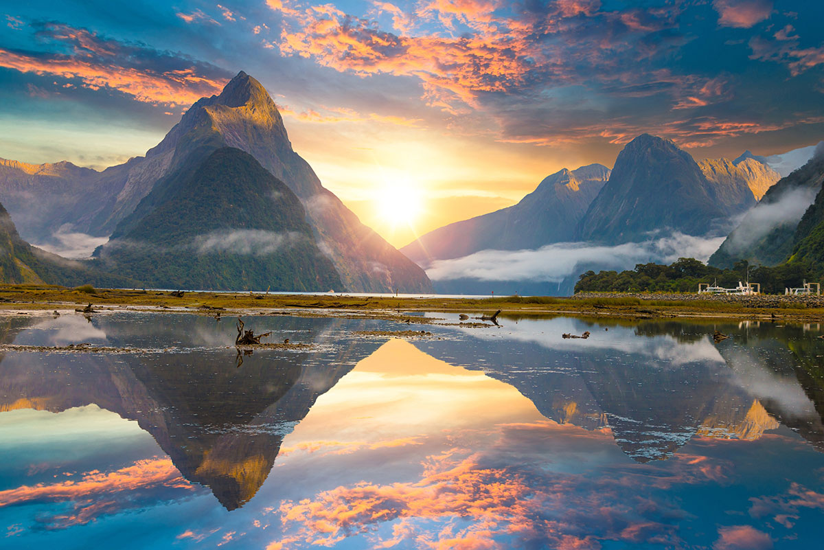
After the trek, do the NZ icon, a Milford Sound cruise. Mitre Peak (1692) and many nice waterfalls (off every cliff in the frequent rain) add to the majestic scenery. The 119km drive back to Te Anau passes through some of the most stunning mountain scenery in the world.

Sutherland Falls
RAKIURA TRACK The day after finishing the Milford, I took the bus to Invercargill and Bluff and then the ferry to Stewart Island. This is a 3-day, 36-km trek. Its first and last days are the same as the 8-10 day Northwest Circuit where virtually everyone sees real kiwis (nobody else in NZ has ever seen a kiwi – the kiwis here are a subspecies that is not nocturnal).
Day 1 follows the nice coast with many pretty beaches.
Day 2 crosses the peninsula on heaps of boardwalk and stairs.
Day 3. After another walk in the woods on the last day, I caught the afternoon ferry back to Bluff. This was my eighth Great Walk.
Mt Taranaki in Egmont NP is a classic volcanic cone (2518m). It starred as Mt Fuji in “The Last Samurai”. Supposedly the most climbed mountain in NZ, it has claimed 60 lives as the weather can change in an instant with snow not uncommon.
It was a hard slog up the scree slopes to get panoramic views. Access is from New Plymouth (49,100), the main town on the Taranaki Peninsula. It is the West Coast’s only deep-water port.

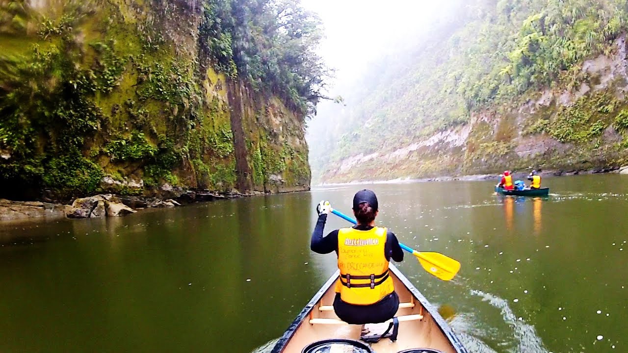
WHANGANUI JOURNEY is a river trip and my last of the nine Great Walks. The river curls 329km from Tongariro to the Tasman Sea and is the longest navigable river in NZ. We drove the scenic Whanganui River road from Wanganui to Piririki where we rented a canoe and 4 watertight barrels. The company shuttled us to Whakahoro to do the 88km, 3 day/2 night version of the trip, with nights spent in huts. This section of the river is roadless and is grade II, easy enough for inexperienced canoeists like us. Beside the scenic canyon, there is a 40-minute walk to the Bridge to Nowhere. The canoeing was exciting and we dumped twice.

Bay of Islands is NZ’s most popular kayak destination. I had a tour with New Zealand Adventures run by an American expat who has lived here for 25 years. He was 60 going on 16 and addicted to kayaking in the surf zone and snorkeling. Rather than kayaking, the strong swimmers routinely snorkelled up to 4 km while I kayaked. In the Cavalli’s, after kayaking through islands with huge sea caves and over the sunken Rainbow Warrier, I gave my kayak to one of the swimmers and hiked the length of Motukawanui Island. In the Bay of Islands, we kayaked around Moturua Island, out to the open coast. We enjoyed gourmet food cooked in his Outback oven, a cooking technique I have added to my kayaking.
Kahoe Farms Hostel is an old kauri farmhouse with the best pizza in NZ. We had some great hikes on his property. He holds the first soccer tournament in the world starting at midnight.
The town of Kawakawa commissioned the Austrian architect, F. Hunderwasser to build one of the most amazing public toilets in the world. With a natural grass roof, not a square corner in the place, wavy ceramic tile work, and bottle walls, they are worth a visit – I went twice.
I spent 5 days in Auckland at the very end and cycled through many marinas (Auckland has more boats per person than anywhere else), to St Heliers beach. In Devonport, I cycled to my cousins to pick up my camping gear.
I spent most of one day doing the Coast to Coast Walk that traverses Auckland from south to north. There are great views from One Tree Hill and Mount Eden and great walks through many Auckland neighbourhoods.
