
In the mid-90s, I went to Patagonia and hiked in Torres del Paine National Park, Tierra del Fuego and Fitzroy. In the winter of 2011/12, I spent several months travelling in South America going as far south as the Lake District of Chile. I also went to Easter Island.
December to March is the best time to be in Patagonia (probably the only time to go). However, this is the rainy season in the rest of South America and not the prime time to trek and hike. June to September have less rain but are also much busier. It rains virtually every day usually in the afternoon. They do not have 4 seasons like us and do not use the words winter and summer but refer to the seasons as the rain and dry seasons. Many high-altitude hikes are not even available at this time of the year. I did not go over 4760 meters and only hiked.
COLOMBIA
Salento and the Valle de Cocora. 6 hours southwest of Medellin is the tranquil town of Salento (pop. 7,000) set in gently rolling hills carpeted in thick forest. The main attraction is the Valle de Cocora, a broad, green valley framed by rugged peaks. The hills are covered with wax palms, and strange 60 metre palm trees towering above the cloud forest. Take one of the many available jeeps from the side of the square to the Valle. The road forks and I took the left fork walking along the road. There are no signs and you eventually take a track that appears to go through private land. This dirt road turns right climbing up the side of a ridge (there was a fresh landslide across the road when I took it). Still climbing, it eventually goes through a gate and reaches a great lookout with benches. Continue on the trail to the park buildings and signs that show the way down. There are several switchbacks down to a big creek with many waterfalls and rapids which you cross a few times on bridges. Eventually, you hit an eroded trail (really used mostly by cattle) that is incredibly muddy. The mud can be avoided as the trail is braided. The trail eventually circles back down the valley past a fish hatchery to rejoin the road at the fork. The hostel I stayed in provided gum boots for all the mud.
PERU
GOCTA FALLS At 771 m, it is the 16th highest waterfall in the world. It is accessed by a tour out of Chachapoyas in northern Peru. It has two drops, the first of 237 m and a second of 520 m. After a great 5 km hike to the bottom of the falls, one gets completely soaked in the huge spray. The surrounding scenery was magnificent with limestone cliffs on the steep mountain sides.
Laguna 69 Also in the Cordillera Blanca, this good day hike has great mountain and waterfall views at a marvellous azure blue lake. Starting at 3900 m, the lake is at 4600 m, all elevations that will induce at least a headache if coming from low elevations. Several companies in Huaraz offer tours.
ARCHAEOLOGICAL RUINS AROURN CUZCO
Take a bus to Pisac, get off at Tambomachay and walk back the 8 km along the road to visit four ruins. The buses leave from Av. Tullumayo, south of Av Garcilaso in Cusco. Tambomachay is a very nice ceremonial bath still channelling clear spring water. Puapukara, the next ruin a few hundred metres down the road commands a great view. It was probably a hunting fort or guard station and a stopping point for travellers. Continue down the road through a small village with bas-relief designs on the front of their houses. Cut across a long corner in the road passing other Inca buildings in the field.
Qéngo, The third ruin, consists of a large limestone rock riddled with niches, steps, and carvings.
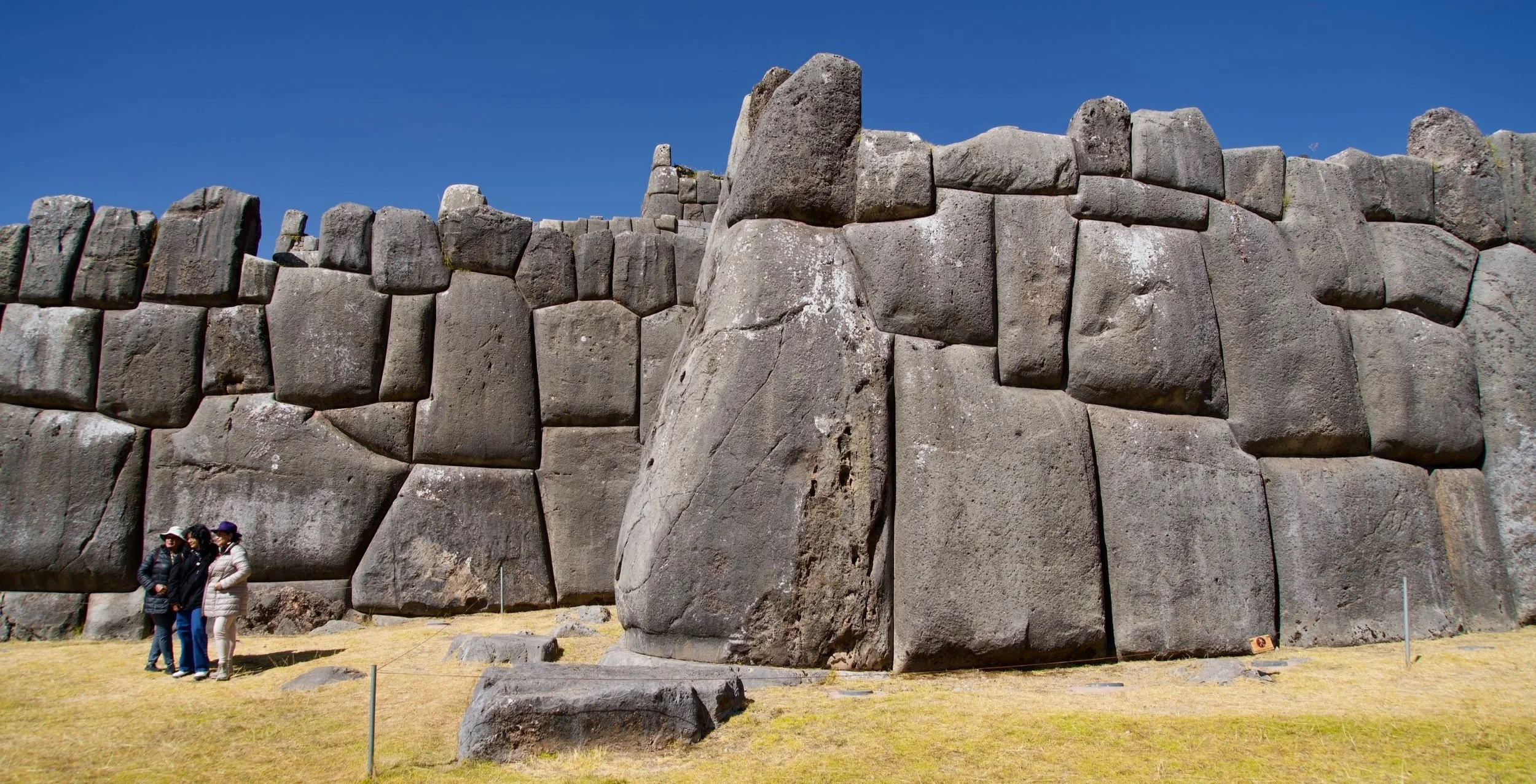
Saqsaywamin. Just down the road is the best of the four ruins, the site of the greatest and one of the last battles between the Spanish and Inca in 1536. Even though only 20% of the original ruin remains (the rest was dismantled and used to build houses in Cusco), what is left is incredible with a long zigzag wall composed of huge polygonal stone blocks, Some, up to 120 tons, fit together in perfect Inca style. The wall is supposed to represent the teeth of a puma with Saqsaywamin as the head and Cusco as the body. Take the Inca road, a steep stone staircase, into town (not the car road on the other side of the large Christ statue).
COLCA CANYON. One of the main reasons to come to Arequipa is Colca Canyon, supposedly the world`s deepest canyon at 3191 m (measured from the top of the mountains, not from the canyon rim). I took a guided tour with Colca Trek – over 100 tour companies offer a variety of trips from bus tours with stops only at the viewpoints to walks along the canyon sleeping overnight in local towns to our trip which went down and then up the same trail. Mules carried our gear. On the 6-hour bus ride there, we stopped at some spectacular eroded volcanic columns above a river, the vicuña protected area (we saw several vicuñas which are wild and many domesticated llamas and alpacas), the town of Chivay for a buffet lunch, and hiked between 2 overlooks (Cruz del Condor) seeing several condors. The upper wide valley has spectacular pre-Inca terracing and the fields are a patchwork of different crops all surrounded by dry rock walls.
We slept overnight in a nice hotel at Cabanaconde (pop 7300), descended 1100m to an oasis at the bottom of the canyon and stayed in tents that night. The river was an incredible torrent and the canyon was spectacular – green up to the top with eroded yellow scars reminiscent of the Canyon of the Yellowstone. The next AM we were up early to climb back up to the top and drive back to Arequipa stopping at several viewpoints and a hot spring on the way. This canyon is hard to compare to the Grand Canyon – its height is measured from the top of the mountains, is certainly as steep but without the cliffs of the GC, and the GC is 2000 feet deeper from the rim.
In retrospect, I would not do the trip with this company – it was expensive and we saw less of the canyon. Many companies offer trips that descend into the canyon farther upstream, stay overnight in a village, walk down the canyon to the oasis and then climb out of the canyon to the rim and the town.
CHILI
National Parque Conguillo. Melipuerco is the town on the south edge of NP Conguillio, renowned for its large stands of monkey puzzle trees or araucaria. Having seen this very unusual tree before in Ronnings Garden on North Vancouver Island (he was a Norwegian who homesteaded there in 1910 and planted a fabulous garden with plants from all over the world), I was keen to see it in its natural habitat and in greater numbers. It is covered with very spiny leaves preventing anything from climbing it.
I did not have a car so as the distance was quite far, it was necessary to go with a tour company for $80. I hired a driver and guide. The trailheads are well-marked and the trails are easy. The big volcanoes here are Sierra Nevada and Lliama (3125m) and we drove for many kilometres past lava flows from large eruptions in the 1850s, 1927, and 1957 and its last eruption in 2009.
The first trek was from near Lake Captren, 4 km to the Mother, the 1800-year-old, 50 m tall, and 3 m diameter Araucaria Madre tree, the largest in the park. We then hiked from the trailhead on the south end of Lake Conguillio, 10 km up the Sierra Nevada Trail to 2 lookouts with many monkey puzzle trees and great views of Conguillio Lake. It is possible to climb all the local volcanoes.
VOLCAN VILLARICA. Pucon (pop 17,000), is touted as the adventure capital of Chile and sits on the shore of large Lake Villarrica. It is European looking with a full range of hotels (many high-end), restaurants and tour companies. The highlight is Volcan Villarrica (2847 m), visible from town with its constantly smoking summit and oscillating red glow at night. It last erupted in 1986 and its caldera is open making it active but with a low likelihood of erupting.
The only reasonable way to climb it (along with hundreds of others – 16,000 climb it each year) is guided by a tour company that outfits you with rigid boots, crampons, a full heavy nylon suit, an ice axe, and a helmet. Taking a ski lift part of the way up, the climb was relatively easy on snow and ice on a glacier and then volcanic rock to the top. The crater was narrow, deep and molten magna spectacularly shot up every few minutes. Pucon and everything below the ski lift was obscured by a dense carpet of clouds. All the surrounding volcanoes stick up through it. The company provides a nylon bib to slide down the snow. The remaining few kilometres down was on knee-saving scree.

National Parque Huerquehue. 35 km NW of Pucon, the 7 km Los Lagos trail switchbacks through a dense mature lenga forest to monkey puzzle trees surrounding a cluster of pristine lakes. The monkey puzzle trees are very unusual looking – straight, limbless trunks with a small umbrella-shaped crown of spiny branches at the top sticking above all the other trees. It is possible to backpack across the park from the lakes to Termas de San Sebastian, hot springs on the other side of the park.
BRAZIL
ILHA GRANDE is a large island 150 km south of Rio de Janeiro. Pick up the free map at the tourist info centre at the end of the dock. It shows all the trails on the island with distances, times, difficulty and access. All the trails are through the Atlantic rainforest.
Parrots Beak. At 982 m this is the second highest point on the island. Walk on a road for 25 minutes from the town to the trailhead marked with a large sign. The trail is easy to follow – at a few creek crossings, it resumes directly across the creek. At the top, the heavily used trail dead ends at the base of the cliff. Instead, follow around to the left under the cliff on a much less obvious trail and access a short scramble that accesses the top. The views from the top are of the entire east end of the island. Try to go early as cloud often comes in the afternoon. It is also cooler. It took me 2 ½ hours up and 1 ½ hours down. The map states that this trail is dangerous and that a guide is necessary but there are no problems.
Aqueduct, old prison and waterfalls. Take the trail at the north end of town to reach a 140 m stone aqueduct built in 1893 to bring water down to Lazareto, the beautiful waterfall called Feiticeira, the Feiticeira Beach, the ruins at Lazareto (originally a cholera quarantine site and then a prison in the 1940s), and then back to Abraao. The howler monkeys were incredibly loud for about 15 minutes around 9:30 in the morning. This was an easy three-hour hike.
Lopes Mendes Beach. This is an easy hike from the south end of town that takes 2 ½ hours to access a beach rated as one of the best in Brazil. It is the most popular hike on the island and passes two other beaches on the way.
Circumnavigation of the entire island. It is possible to do this over 3-4 days camping on beaches. There is a gap in the trail where the map states that one needs authorization to go along 2 beaches through a biological reserve.
HIKES AROUND RIO de JANEIRO
Ipanema, Copacabana Beaches, and Sugar Loaf. This is an urban walk along the two famous beaches of Rio with crashing surf. Walk on the sand near the water or on the sidewalk. It is not possible to walk on the water between the two beaches. There is a fort that you can enter for a fee. At the end of Copacabana, turn left, go through the tunnel, turn right to go through a shopping mall and then walk the side streets to the cable car that goes up Sugar Loaf. This 396 m quartz and feldspar monolith sits on the water at the west entrance to the harbour of Rio. Transfer cars at an intermediary stop. There is a short walk down that gives great 360-degree views. The trailhead for Sugarloaf is located at the end of the paved Pista Claudio Coutinho, a scenic walkway that originates from Praia Vermelha in Urca and hugs the lower slopes of the mountain. Squeeze past the tiny lighthouse to reach a narrow, slippery path that ascends the 45-degree slope. Past the halfway point there is a 20 m rock climbing segment.
Tijuca National Park. This is the only National Park in Brazil inside a city and is one of the largest urban parks in the world. Most of the trees were cut down for coffee plantations in the 1800s. In 1861 40,000 trees were replanted over 10 years and are now mature second-growth Atlantic rainforest. There are 3 trails easily accessed by car. The area was completely deforested and used primarily to grow coffee
a. Corcovado and Christ the Redeemer statue. Christ the Redeemer is now one of the seven wonders of the modern world. It is an instantly recognizable icon for Rio and Brazil. Made of reinforced concrete, it is 130 feet tall including the 31-foot base, its outstretched arms are 96 feet wide and it weighs 635 tons. It is the largest Art Deco statue of Christ and the 5th largest of Christ in the world. It can be seen from all of Rio. It is lit up at night.
The good easy-to-follow trail to the top starts at the NE corner of Parque Lage just north of the large lake, Lagoa Rodrigo de Freitas in Leblon and Ipanema neighbourhoods. Try to start early when it is cooler as Rio is hot and humid. Beat the clouds that roll in in the afternoon. This also gives you time to do other trails in the park. A guard station at the trailhead has good free English maps of the entire park and the trail. The trail is very steep in a few places and scrambles up a slippery rock equipped with a chain. Follow the rail tracks for good views. Don´t go to the rail station, follow the road just before the station. Pay an 18 Real entrance fee which also covers the short van ride down to the main road, Estrada das Paineiras. Surrounding the statue are many terraces with spectacular views of every neighbourhood in Rio. This is better than Sugar Loaf to get orientated to the city.
It was a long hike down the road through Cosmo Velho and Laranjeiras taking 2+ hours to get to the metro station at Largo Machado in Flamengo.

b. Pico do Tijuca. At 1022m this is an easy trail taking 1 hour to the top. Near the top is a staircase of 117 steps carved out of the rock with deteriorated chains for assistance. The trail starts near the park visitor centre at 685 m accessed from Alto da Boa Vista on Cascatinha Road.
PATAGONIA
TORRES DEL PAINE NATIONAL PARK, Chili
This 181,000-hectare park, a Unesco Biosphere Reserve, has amazing landscapes. Soaring vertically more than 2000m above the surrounding Patagonia steppe, the granite pillars of the Towers of Paine are one of the most spectacular sites on earth. Weather can be wild and unpredictable, with cold, sudden rainstorms, and big winds. 150,000 visitors visit every year, of which 60% are foreign tourists. Fires set by tourists burned down large portions of the park in 1985, 2005 and 2011.
The park is 112 km north of Puerto Natales (pop 20,000), the only close town with regular buses to the park. Access Puerto Natales on a 4-day boat, the Navimag departing Puerto Montt. The only airport is 200 km south in Puerto Arenas on the Strait of Magellan,
Mountains. The Paine massif rises dramatically 2000m on the east side of the Grey Glacier. Glacial erosion is responsible for sculpturing the massif in the last tens of thousands of years. The Torres del Paine are 3,050 meters above sea level, with their overlying sedimentary rock layer completely eroded, leaving behind the more resistant granite rising as several yellow towers.

The Cuernos del Paine (Horns of Paine) have central bands of exposed granite and chocolate, dark tops forming a strong contrast.
Three valleys separate the spectacular granite spires and mountains of the massif and trails ascend each for the three-day hikes of the W trip: The Ascencio Valley (most easterly valley) is the normal route to reach the Torres del Paine lookout (Mirador Las Torres).
The French Valley (Valle Frances), the central valley, ascends into the center of the massif and has spectacular towers. Lago Grey fills the westernmost valley with Glacier Grey at the north end of the lake.
Glaciers. The Southern Patagonian Ice Field mantles the entire western side of the park. Glaciers that extend down from the main ice field include the Pingo, Tyndall, Geikie, and the largest, Grey. Grey Glacier t is divided into two arms by an island of rock called a Nunatak – 15 km long, the eastern arm is 1.2 km wide and the western arm is 3.6 km wide.
Lakes. The lakes include Grey, Pehoé, Nordenskjold, and Sarmiento and extend across the south side of the massif. The lakes are all vividly coloured from rock flour suspended in the water. The park’s lakes drain into the Serrano River that empties into Última Esperanza Sound.
Flora. Torres del Paine National Park is adorned with beautiful vegetation, including an evergreen which produces vivid red flowers of striking shape and colours, 7 documented species of orchids, 85 non-native plant species with 75 of European origin and 31 considered invasive. The park contains four vegetation zones: Patagonian steppe, Pre-Andean shrubland, Magellanic subpolar forests and Andean Desert above the tree line. All are resistant to harsh winds and weather typical of the Patagonian region.
Fauna. Guanacos, fox and pumasare are common. Birds include the Andean Condor, Buzzard-eagle, Rufous-tailed Hawk, Cinereous Harrier, Chimango Caracara, Magellanic Horned Owl, Austral Pygmy-owl, Chilean Flamingo, Rhea, swans, Magellanic Woodpecker, goose and ibis.
Accommodation. Refugios provide shelter and basic services. Reservations are necessary for the peak hiking season. Dinner, hot showers, optional breakfasts and picnic lunches are provided. Camping is only at specified campsites and wood fires are prohibited throughout the park. Rent a tent and sleeping bag to sleep on the grounds outside the refugio with cold showers, or pitch your tent and cook on a camp stove.
Climate. Visiting the park is recommended between late December and late February, the southern summer. The weather is more hospitable, and daylight hours are long at the extreme southern latitude. Outside of this, the weather becomes too extreme for most, and daylight dwindles.
Hiking. Most everyone comes here to hike. The trails are good and route finding is easy. The entrance fee was 18,000 pesos (US$40) and the bus was expensive.
Catch the 2-hour bus from Puerto Natales leaving at 7.30 am or 2.30 pm (JBA has the cheapest rates) to the Visitors Centre/Administration at Laguna Amarga.
1. W Trek: Think of this trip not as a true W but as three valleys running north/south into the mountain massif. Two horizontal sections connect the three. Arrive the day before and stay at Las Torres for two nights (Refugio Las Torres Norte, Refugio Las Torres Central, Las Torres Servicio Camp Site, Eco Camp or Hosteria Las Torres).
Day 1. Get an early start for the best light.
Las Torres to Campamento Torres (9 kilometres, 3.5 hours): The first 2.5 km is steep.
Campamento Torres to Mirador Torres (45 minutes – 1 hour) is a steep rocky ascent. The Mirador is at the base of a beautiful milky green tarn with views of the three towers. The highest mountain of the group is Paine Grande at 2,884 m (9,462 ft). Return to Las Torres for the night.
Day 2. Hike west along the north side of Lago Nordenskjold to Los Cuernos (11 km, 4.5-5 hours) to sleep at one of Refugio Cuernos, Cabanas Cuernos or Campsite Cuernos.
If camping, one could continue to Campsite Italiano at the base of the French Valley.
Day 3. From Los Cuernos, hike to Campsite Italiano (5.5 km, 2.5 hours) and ascend to Mirador Britanico (7.5 km one way) at the end of the trail (Campsite Britanico). The French Valley has at its head a cirque formed by impressive cliffs. The colossal walls of Cerro Cota (2000m) and Cerro Catedral punctuate the western side of the Valley. To the north stands the granite arête called the Shark’s Fin. To the east, from north to south, are the Fortress, The Sword, The Blade, the Mummer, the North Horn, and the Main Horn. Descend to Campsite Italiano for the night.
Day 4. Hike west to Paine Grande on the NW corner of Lago Pehoe (7.5 km, 2.5 hours) to stay at Refugio Paine Grande, Paine Grand Domes, or Paine Grande Servicio Camp Site. Continue north along the east side of Lago Grey to the viewpoint for the Grey Glacier (11 km, 3.5 hours). Refugio Grey, Grey Servicio Camp Site or Campamento las Guardass are one-half hour before the viewpoint. The 15 km long Grey Glacier is the largest in the park and is divided into two arms by an island of rock called a Nunatak. The eastern arm is 1.2 km wide and the western arm is about 3.6 km wide.
Day 5. Return on the same trail to Paine Grande, take the Catamaran across Lago Pehoe to Pudeto (Refugio Pudeto) and catch the bus back to Puerto Natales.
2. Circuit. Doing the Circuit gives you bragging rights, solitude and some stellar views not on the W. The Circuit is composed of the ‘W,’ plus the backside between Refugio Lago Grey and Refugio Los Torres. There are no refugios along this stretch and camping is basic. You need foul-weather camping and trekking gear, as mud (sometimes knee-deep), snow and wind are inevitable. Trekking alone is inadvisable (and restricted by Conaf). The Circuit is closed during winter.
Day 1. Refugio Lago Grey to Campamento Paso takes four hours from Campamento Guardas to Paso, about two hours going the opposite way. Hiking west to east means ascending the pass rather than slipping downhill.
Day 2. From Campamento Paso to Camping Los Perros – four hours. This route has plenty of mud and sometimes snow. Camping Los Perros to Dickson – 4½ hours, and relatively easy but windy.
Day 3. Camping Dickson to Seron – six hours. As the trail wraps around Lago Paine, winds can be fierce and the trails vague. It’s possible to break trek at Campamento Coirón.
Day 4. Camping Seron to Laguna Amarga – four to five hours.
3. Descending the Serrano River. Once you have finished Torres del Paine National Park, it is possible to return to Puerto Natales by an uncommon route – descend the Serrano River in a sea kayak or raft over 2 days/1 night. The start has views of Chacabuco Cordillera and Balmaceda Mountain. At Serrano Waterfall is a 200-meter portage. Camp at Pekin Guerrero’s Estancia with views of the Tyndal Glacier. From the ranch, walk to the Geike Glacier, a spectacular high-altitude lake full of ice.

Back in the kayaks, continue to Puerto Toro where two national parks abut each other. A little trek gives views of the Serrano Glacier. Board the ferry to cross the Última Esperanza Fjord. If the weather allows, there are spectacular views of the Paine massif.
TIERRA DEL FUEGO
Tierra del Fuego, the Land of Fire, is an island divided between Chile and Argentina at the southern tip of South America. Ushuaia, on the south coast, overlooks the Beagle Channel and is the base for the best hiking. It bills itself as la Ciudad del Fin del Mundo – the City at the End of the World. There is nothing below this windswept place but 650 miles of treacherous southern seas and Antarctica.
Parque Nacional de Tierra del Fuego, 12 km west of Ushuaia, is the southernmost tip of South America. Rich in forests, lakes and jagged mountains, it is a beautiful but tough landscape, tormented by unpredictable weather.
Laguna Esmeralda. This full-day hike starts at the Altos del Valle ski resort and ascends to the beautiful Laguna Esmeralda. If you are up for a true trekking challenge, continue past the lake, to where the vegetation ends, and the Glacier Albino begins.
Sendero de Lucas Bridges. An excellent trek between the two great estancias in Tierra del Fuego, The Haverton and the Via Monte Estancias. You can stay at the estancias at the start and end, while you camp during the hike.
Andorra Valley and Laguna del Caminante. This three-day trek shows you the highlights of the Tierra del Fuego mountain range and is packed with awesome views of Beagle Channel and the famous Darwin Range. Easy to moderate hiking takes you to beautiful places on this overview hike. Camp.
Bahia Lapataia. A 3-hour, 9.6 km coastal walk between two beautiful bays on the southern shore of the Land of Fire. This hike has no elevation change as it follows the Coastal Path from Bahia Ensenada to Bahia Lapataia, with beautiful views over the Beagle Channel.
FITZROY Argentina
To complement any trip on the Chilean side of Patagonia there is “Los Glaciares National Park” in Argentina. Los Glaciares is one of the most scenically impressive national parks in South America. This vast reserve protects 2300 square miles of the Patagonian Andes, including over 40 major glaciers. The northern section of the park is dominated by the incredible, world-famous Fitzroy Massif, with its sheer, 6000-foot rise from the glaciers at its base.
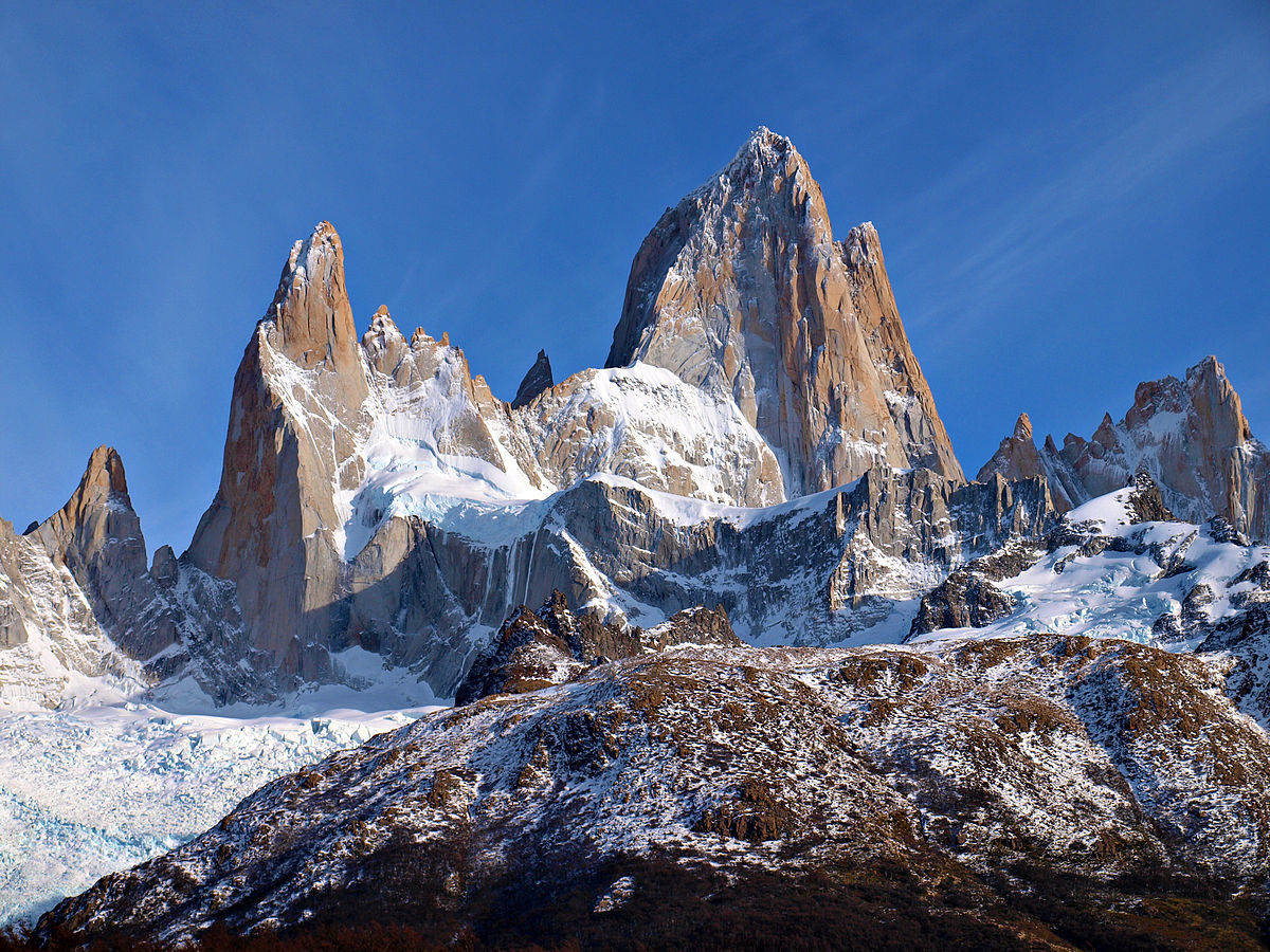
Numerous spectacular mountains rise above the immense Lago Viedma, including Fitzroy 3405m (11,072 ), and Cerro Torre 3128m (10,280 ). The latter is such a steep and difficult granite needle that its summit was not climbed until 1974. The southern section is one of the world’s glacier wonderlands (40 percent of the park is covered by glaciers). About a dozen glaciers flow east to feed two huge lakes, Lago Viedma and Lago Argentino, and there are another 190 glaciers not connected to the park’s giant South Patagonia Icefield.
Fitz Roy is at the northern tip of gorgeous Parque Nacional Los Glaciers, itself part of Hielo Sur, the largest icecap not in a polar region. The history of these impossible spires adds a special flavour. It’s named after Cpt Fitzroy, skipper of Charles Darwin’s Beagle. Fitz Roy is one of the most famously difficult mountaineering destinations in the world.
The jagged mountains of Paine are surreal — but Fitzroy is even more stunning. Hikes here are slightly easier than Paine and more suitable to all levels of ability and experience. It’s easier to hike independently in Fitz Roy, there is no need to filter water, and no risk of altitude sickness, Argentina is less expensive than Chile, and most hikers like El Calafate more than Puerto Natales.
The biggest concern for hikers is wind. It can blow steady from November to April. Fitz Roy is colder than Paine as the huge Hielo Sur ice sheet diminishes the maritime influence. At El Chalten the February low maximum 5°C plus wind chill and a high maximum of 22C (72F). If you are not there in February, it will be colder again. Plan for horrible weather: rain, sleet, hail and snow. Hypothermia is a risk. You need a strong tent & good tie-downs to survive the wind & weather plus a stove as fires are prohibited. Most hike independently and few are guided. November to April are the best months. January & early February first-come, first-served campsites are crowded, but not as much as Paine. The days are long in Patagonia during the summer — it is light until at least 10 pm. The only hiking allowed in Parque Nacional Los Glaciers is around Fitzroy.
Head for the bustling tourist town of El Calafate, Argentina. Many hikers fly or bus there from Buenos Aires, Argentina.
Some hikers fly to Chile first to hike Paine, then bus to El Calafate. It is normally easy to cross the Chile – Argentina border. From El Calafate, you need to schedule a full extra day to visit the must-see Moreno Glacier. From El Calafate you can bus 4.5 hours to the Fitzroy trailhead town of El Chaltén, entering the national park (free entrance) en route. No reservation, trekking fee or permit is required. It is easy to day hike out of a hostel or hotel in El Calafate. Accommodation & restaurants are surprisingly good in tiny El Chalten. It is no hardship to relax there, waiting for the winds to drop. There is even a free campground on the edge of town.
Argentina has good value if you are holding foreign currency. It is far cheaper than Chile.
The welcome and information provided at the National Park visitor centre (Parque Nacional Los Glaciers) in El Chaltén is terrific. It’s the best park office in South America.
The Around Fitzroy trek is 38km plus side trips. It is recommended to take 4-5 days, 3-4 nights minimum. Instead of hiking directly into the park, start by hiring a ride up Route 23 and get dropped off at the trailhead and hike to Refugio Troncos (NW of Laguna Piedras Blancas) to camp, where you can day hike to the Cerro Electrico Lookout. From Refugio Troncos, start the trail and take the short side trip to Laguna Piedras Blancas, before camping at Campamento Poincenot and take in a front stage view of Mount Fitzroy.
It’s worth getting up before dawn to climb to Lagos de los Tres for sunrise. Come back for breakfast/lunch and head down the trail to Laguna Sucia. The private walk along the riverbank is a more heavily travelled path to Lagos de los Tres. Few venture down it and its wonderful view from Laguna Sucia.
Hike to Campamento De Agostini along Laguna Madre and Laguna Hija. These lakes make a great backdrop for your last close-up views of Mount Fitzroy and can make for a refreshing swim. Once past the lakes, you’ll snake through a yellow wildflower-laden forest before getting views of Cerro Torre. Once again get up for the sunrise, as it’s the best view of Cerro Torre and then head back to El Chalten.
The standard route has tents at Agostini, Poincenot & Refugio Los Troncos (which sells snacks & meals). An extra day is helpful in case of weather or to add some side trips. Extreme hikers could (carefully) consider the Ice-cap Circuit variation described in “The Andes, A Trekking Guide.”
Laguna de los Tres. An easy 8-hour round trip from the town. There are outstanding views of the Fitz Roy range along the way. The trail ends at the cobalt-blue Laguna de los Tres, at the base of Cerro Fitz Roy. The last 1.5 kilometres of this hike are very steep and exposed, and some hikers choose to overnight at the nearby Campamento Poincenot before the last difficult stretch. A 500-meter, well-marked additional trail winds around to the left of Laguna de los Tres and leads to a spectacular, cliffside overview of Laguna Sucia, some 200 meters below Laguna de los Tres. A good alternative route is to start at Hosteria El Pilar and hike back to El Cheltan, stopping at Laguna de los Tres mid-way.
Laguna Torre. 6 hours easy round trip that leads to a lake at the base of the dramatic Cerro Torre, which, although only 3100 meters tall, was not summited until 1975, a generation after all the 8000-meter+ Himalayan peaks had been conquered. Cerro Torre’s near vertical walls and a permanent, unstable ice veneer at its summit defeated all earlier attempts. Backpackers can combine the Laguna de los Tres and Laguna Torre treks using connecting side trails that create a loop. An optional side continuation to Dagostini leads closer to the glacier near Laguna Torre.
The Condor Mirador and Eagle Miradors are easy climbs (two hours at most combined) behind the National Park office. There are great views of the town, the Fitzroy range and of course Condors.
A boat trip can be combined with a glacier trek on the Lago Viedma and the adjacent Glacier Viedma.
Horse riding with a gaucho guide along some of the major walking trails is possible.
VENEZUELA
ANGEL FALLS
I flew 1 hour to Puerto Ordaz on the border of Guyana and then bussed 1 ½ hours to Ciudad Bolivar staying at Gekko Tours who organized both my trips. Then fly in a slow tiny Cessna 172, 1 ½ hours south to air access Canaima (pop 1,200). It is a cute town with dirt streets on the edge of a big lagoon with big waterfalls.
A boat on the lagoon gives close-ups of the 6 waterfalls, a mini version of Iguazu. Walk on top over some dry riverbeds, swim in beautiful pools, and then come down to walk behind the biggest waterfall – 80 m on a rock walkway under a large overhang. This was an amazing experience as the falls were huge with lots of spray.
The next day we drove to above the falls and boarded a long narrow dugout canoe for the 5-hour river trip to a camp near Angel Falls, the highest waterfall in the world at 979 metres. As it was still dry season, the coca-cola coloured water in the river was low and the skill of the boat driver negotiating all the rapids was very special. Through the jungle, the riverbank was full of cobble beaches.

The landscape must be one of the most spectacular on earth as we travelled around huge mesa-like tablelands called tepui with 600-900 m high vertical cliffs and a few waterfalls. The yellow/pink sandstone is 2 billion years old and through water erosion forms these huge individual mesas with their massive cliffs. There are 100 tepuis across Venezuela and most are in the east.
Taking a smaller tributary, the river became progressively narrower, and the rapids more frequent. One area had huge boulders in the river. After arriving at the jungle camp, we immediately hiked 45 minutes up to the base of the falls. Falling from the edge of the tepui, the water hits terminal velocity ⅓ of the way down and is mist the rest of the way.
We swam in a pool under a lower waterfall. Sleeping in hammocks, it rained all night and the falls were invisible in the cloud the next morning. The river was now at least a metre deeper and the trip was a high-speed ride taking only 3 hours back (including an hour hike around rapids on the way up). I then flew back to Ciudad Bolivar in a Cessna 184 and then took a 12-hour bus south to Santa Elena to access Roraima.
