It was a 5 1/2-hour flight from Santiago, Chile to Easter Island (called Rapa Nui “Navel of the World” by its inhabitants and Isla de Pascua by Chileans). Discovered by a Dutch ship in 1722 on Easter Sunday and visited by Cook in 1774, Easter Island has the most astonishing story of ecological collapse on earth.
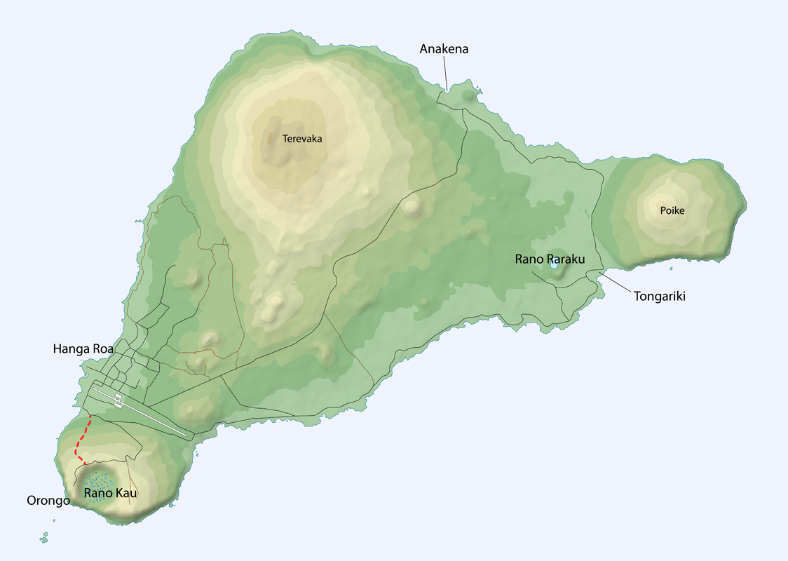
Triangular shaped with volcanoes on the 3 points (3 million, 2 million and 200,000 years old), its underwater area is 50x the 166 square kilometres above water. There are at least 20 more small cones, the largest of which formed the quarry.
It is the area of land furthest from any other land on earth – 2100 km from Pitcairn Island, 3700 km from Chile and 4000 from Tahiti.
History. Settled in 400 AD by Polynesians who had spread across the South Pacific, it developed an incredible culture best known for erecting huge volcanic rock statues (moai) revering their rulers. This form of ancestor worship started in the 10th century. The island was covered with forests of an estimated 16 million palm trees. They had a slash-and-burn agricultural policy and the population exploded to 25,000 inhabitants. It is believed they also used the palms as rollers to move the moai from the quarry to the erection sites as they did not have the benefit of wheels. Palm nuts were also eaten by rats that came with the original inhabitants. Without natural enemies, the number of rats went out of control and their diet of nuts prevented the natural regrowth of the palms. Over a few centuries, they had cut down every tree on the island. As a result, they had no canoes to catch big fish and were marooned on the island. A civil war between the five tribes resulted and their culture collapsed.
Recent archaeological studies have concentrated on the 320 caves (many lava tubes) that have been discovered. In the 16th century, fish bones became smaller and were eventually replaced by the bones of birds. Originally the island had a huge bird population but 24 of the 25 bird species were wiped out. A vast increase in weapons (as evidenced by obsidian arrows and spearheads) was also coincident with the change in diet. Small statues were found with exposed ribs and big bellies indicating widespread starvation. One large cave on the coast was called “eat man cave” and it is thought that cannibalism also occurred. Caves became common places of habitation as they were more easily defended. The island of Eden turned into a hell.
Power centres were where the moai were erected. These also became the points of conflict. As a clan was defeated, its moai were pulled down and the eye sockets gouged out. Some tribes fared better than others because of location. For example, one cave had a good source of fresh water. Almost all moai were toppled in the civil war by the 17th century. Warriors dominated as they had control of the limited food and water supplies.
Ancestor worship was over and a new political system called the birdman cult developed in the 18th century as a means of survival. Once per year, to determine who had economic control, a race was held where one man per clan ran down the cliff and swam a mile to a small island to obtain an egg of the sooty tern. The first to get an egg earned the title of birdman and became the absolute ruler of the island. This solution was more democratic than heritage. Resources were distributed based on this system. This brought the society back from the point of destruction.
But it was short-lived as a few decades after the birdman cult started, a new threat arrived. In 1722 on Easter Day, a Dutch ship arrived and disaster struck. With the first encounter, a battle ensued. Over the next 50 years, more Europeans came. Caves became a common refuge for the islanders. But the island had little to offer and few stayed. Diseases like syphilis killed thousands. When the population was down to 4000, 1500 natives were taken by slave traders to South America. They subsequently returned with smallpox.
By 1877, there were only 111 people on the island – a mixture of many nationalities. It was called the “Island of the Dead”. It was not until 2003 that the population returned to that 4000 number, most descendants of the originals. It is the greatest story of the collapse of a culture due to environmental degradation on Earth.
Day 1. Most people live in Hanga Roa on the SW shore with 4400 people. At 27 degrees south, the climate is subtropical with a few brief rains. Because of the limited gene pool and as incestuous relationships are not frowned upon, there are many genetic problems among the natives. Everyone is related to everyone else.
Food especially in restaurants was expensive and at least 3x mainland prices. My dorm room in a hostel however was only $14/night, it was in a great location on the west point of town with a 10-minute walk to the central area. I cooked all my meals here.
There are at least 890 moai, over ⅔ still in the quarry. They are monolithic human figures carved between 1250 and 1500. Nearly half are still at Rano Raraku, the main moai quarry, but hundreds were transported from there and set on stone platforms called ahu around the island’s perimeter. Almost all moai have overly large heads, which account for three-eighths of the size of the whole statue. They also have no legs. The moai are chiefly the living faces (aringa ora) of deified ancestors (aringa ora ata tepuna). The production and transportation of the more than 900 statues is considered a remarkable creative and physical feat. The tallest moai erected, called Paro, was almost 10 metres (33 ft) high and weighed 82 tonnes. The heaviest moai erected was a shorter but squatter moai at Ahu Tongariki, weighing 86 tonnes. One unfinished sculpture, if completed, would be approximately 21 m (69 ft) tall, with a weight of about 145–165 tonnes. Statues are still being discovered as of 2023.
With an average weight of 9.5 tons, all except for size, are virtually identical with a prominent brow, deep-set eyes, long nose with broad tip, prominent cheeks, thin lips, prominent chin, long ears, long arms and long fingers. They are made from the same type of volcanic rock with a yellowish tint and a red volcanic rock top knot.
All were toppled during the civil war and many were scattered by a large tsunami in 1960. On the first day, I went to the 9 am mass in the Rapa Nui language. The church was packed with a big standing-only crowd flowing out the door.
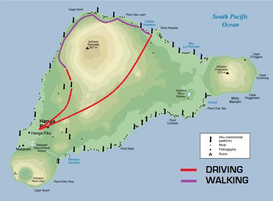
After visiting the excellent museum, I had a long climb to the high point on the island, Terevaca at 507m, the youngest north volcano. At the start are 7 standing moai, the only ones to face the ocean to the west. These were reerected by Thor Heyerdah.

There was no crater on top, simply a long ridge in the howling wind.
 ]
]
It was a gorgeous walk down to the east through high grass, stands of big eucalyptus trees and many wild horses.
Day 2. With 2 young Chileans and a Korean, we walked along the west coast bypassing the west side of town, remnants of the original buildings, and 3 caves that are lava tubes. On the north coast is a minimal trail that goes 8 hours to the best beach on the NE corner of the island at Anakena. Through grass and lava rock, it was wonderful along the cliffs with many wild horses, several ahu (platforms for moai) and a few moai, all fallen. It was a welcome swim at the lovely Anakena Beach – white sand surrounded by palm trees and 7 standing moai. It is the only beach on the island. I hitchhiked back to town.

We also visited many ahu with fallen moai on the south coast.
Day 4. We saw sunrise by the 15 moai, I climbed the southeast volcano (400m) alone and then walked cross-country to the quarry where all the moai were obtained.
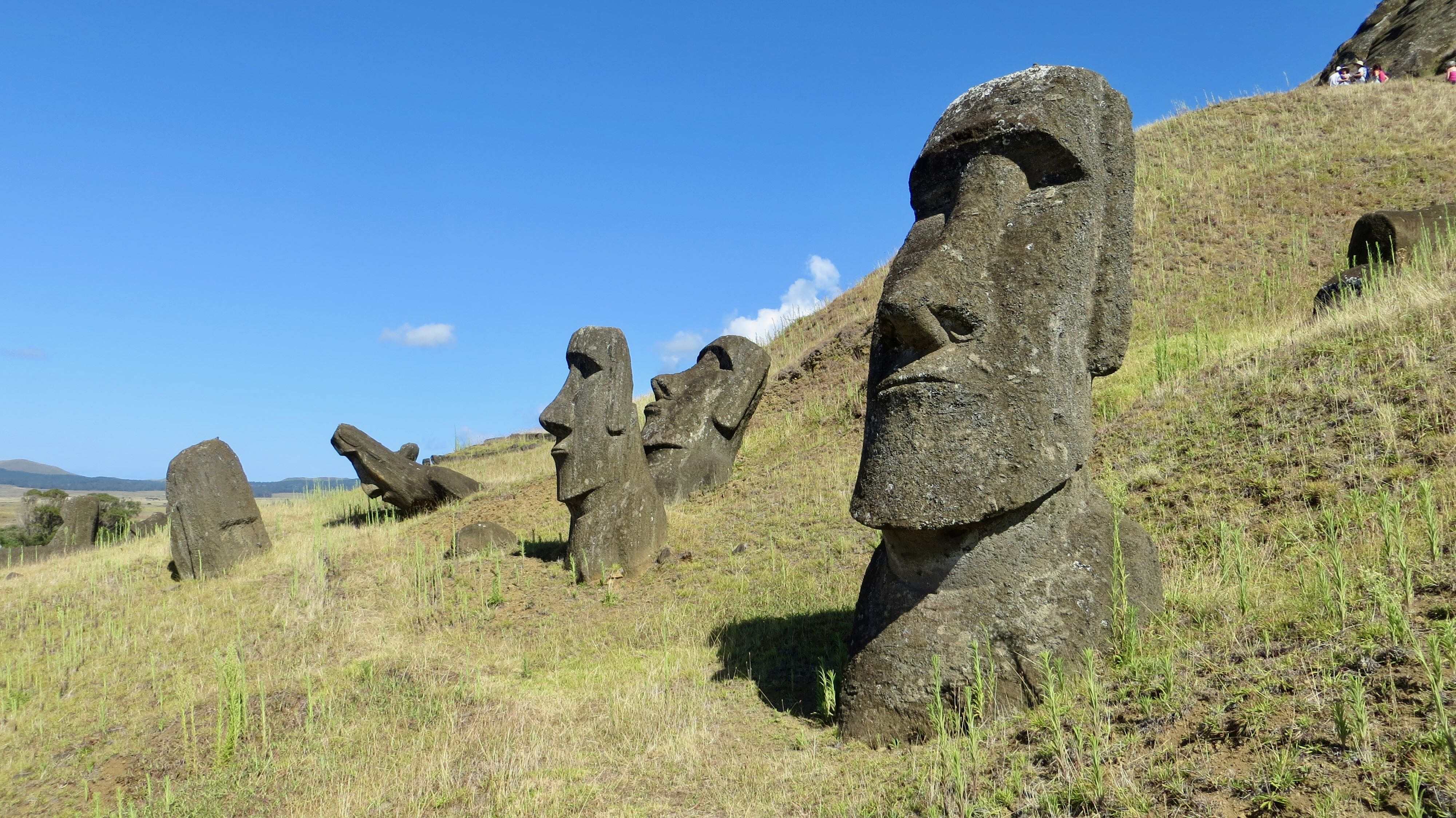
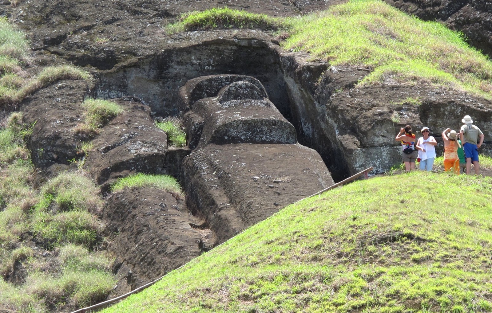
Many were lying and standing including in the large crater with a lake. I approached the quarry walking cross-country and entered it from the east. I then exited at the normal entrance much to the surprise of the women in the ticket booth.
That afternoon, I went snorkelling. It was a nice boat ride along the west shore to Motu Nui, an island on the SW tip that was the centre of the Birdman cult. The visibility was unbelievable and there were many corals but few fish. The area to be explored was small around a small rock as the ocean was very active.
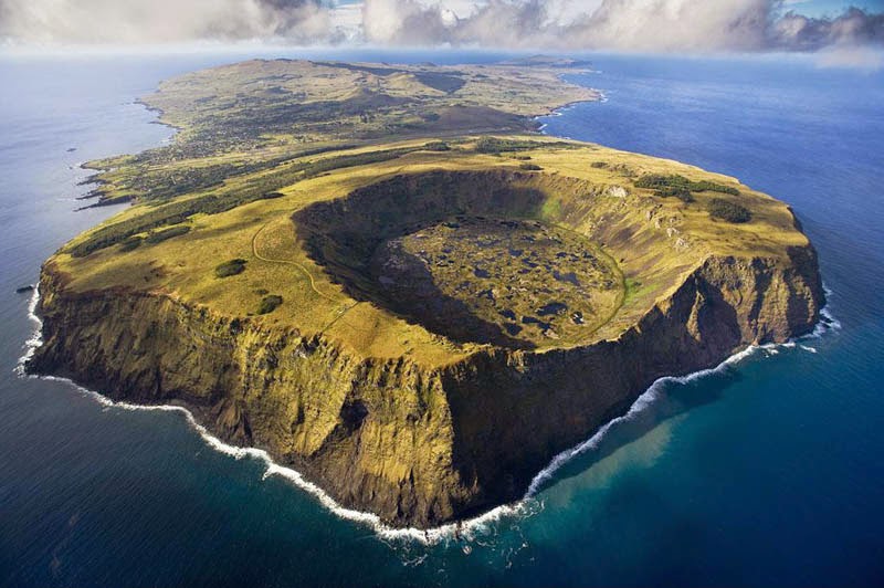
Day 5. On my last full day, I climbed Orongo (410m), the volcano on the SW corner.
It has a huge perfectly round crater with a flat bottom and interspersed ponds. The south edge has a big gap eroded by the ocean. This is the site of a village used only for a few weeks of the year and is the only site on the island with religious significance. There are about 40 round houses built of slab rock on a tiny point on the edge of the crater and thousands of bas-relief petroglyphs.
The site was used to celebrate the birdman cult which replaced ancestral worship in the 15th century. The competition to be leader involved swimming to Motu Nui and trying to be the first to get a sooty tern egg. The last competition happened in 1867. It was a gorgeous walk down the cliff edge and I then the water back to my hostel. On the way were spectacular lava formations and a cave with a few birdman paintings.
I’m confident I had the best, most active time possible on Easter Island. I climbed all three volcanoes, descending each in unusual, trailless ways. The hike on the no-trail NW coast was one of the most spectacular walks of my life. I walked to the quarry cross-country from the east volcano.
Hitchhiking is a great way to get around. I would encourage anyone going here to do all these things – a much more authentic way to see the real island. Miss the tourists. Most rent vehicles and tour guides and see the highlight moai, walk around the town, and eat in restaurants.
I flew back to Santiago and immediately got on the bus for a 24-plus hour trip to Buenos Aires via Mendoza.
