
OFF-TRAIL HIKING IN WATERTON LAKES NATIONAL PARK
My ex-wife’s family had a beautiful cabin in the Waterton townsite and I had the opportunity to hike this park for portions of 18 summers. This is where I first started hiking and developed my love for walking and exploring mountains. I virtually always hiked alone.
Besides hiking all the trails, I climbed every mountain at least once and walked every ridge. I started a register program and put a book in a plumbing tube on every peak (unfortunately these were not maintained after I stopped going to the park).
I was also interested in writing a book on off-trail hiking in the park with the cooperation of the Waterton Lakes Natural History Association. It did not receive the blessing of the park service and thus never happened. This is understandable – Waterton is such a small park with few places for the animals to go, and encouraging people to go all over the place would be an unwanted side effect.
Days without wind are rare. The average wind speed is 35km/hour and occasionally up to 160km/hour. Warm Chinook winds have a dramatic effect on temperatures, especially in the winter. In January 1966, in nearby Pincher Creek, Alberta, the temperature rose 21°C in 4 minutes
Waterton has an entire range of environments, from wetland to prairie to alpine.
Here is a summary of most of the off-trail hikes available in the park. You will recognize few of these as they all involve climbing mountains and walking ridges. My directions are purposely somewhat vague. Part of the adventure is discovering the route either up or down.
My purpose is to give you some ideas of great places to go that are not in the standard books on hiking. Good topographic maps are necessary to understand where you are going and scope out each hike. Many are long days so plan accordingly.
MOUNT FORUM
This mountain is on the BC-Alberta border just above the US-Canada border. It gives great views down to Cameron Lake and the big mountains to the south in Glacier NP in Montana. The bear grass here is often world-class.
Take the Akamina Parkway 14.4 km towards Cameron Lake and park at the Akamina Pass trailhead on the right before the lake. Walk up the trail 1.6 km to the pass and turn south to walk up the border cut. It has one steep part. When you reach the cliff below the top of the mountain, take the animal trail that continues under the cliff to the low point of the ridge where it switchbacks briefly to the top. Turn east and walk up to the summit. It is not obvious what is the true top as a few cairns all appear to be the same height. It is possible to climb down to a very special border marker at the continental divide/US/Canada border. It is a difficult scramble and I may have been the only one there.
MOUNT CRANDELL
Crandell is the mountain above the visitor’s centre. From the summit, one gets panoramic views of the townsite and down to the hotel and the lake.
From the park visitor’s center, take the trail up to the Bears Hump. Start the big climb up the ridge. At each cliff band, bypass them to the left. There is minimal scrambling to get to the summit.
To get back down, there are three choices. Returning the same way poses some difficulties as from above the route is not obvious even though you just came that way! The ridge to the NE takes you down towards the golf course. My favourite is the long ridge heading west towards Crandell Lake. On top, I once walked beside a large herd of male mountain sheep. When above the lake, pick the easiest way down and then walk around the south side of the mountain back to your vehicle.
MOUNT BLAKISTON and LINEHAM LAKES
This is the highest mountain in the park and makes a great climb with panoramic views of most of the park as it is in the center of the park. There are five lakes in the Lineham Lakes basin. There used to be a map at the trailhead showing the 100m high Lineham cliff and how to negotiate it, but after an accident, the cables were removed along with the map. The first time I was here, I had never been on the cliff, the route was not obvious from above, and I followed a goat down the cliff to the south of the falls. As almost no one goes here because of the cliff, it is a mecca for wildlife.
Drive the Akamina Parkway 9.3 km, park at the Lineham Lakes trailhead and walk the trail until you come to a gully coming down from west of the summit of Blakiston. After climbing to the top of Blakiston, return along the ridge and continue to circle to the north end of Lineham Lakes basin. Work your way down to the upper lake, walk through the basin and then down Lineham cliff. One can go down either side of the falls. Both routes are game trails. Although not obvious from above, either way works fine. Work your way down the ledges. Apparently, this requires a climbing permit now.
MOUNT VIMY and CRYPT LAKE TRAIL
Vimy is across the lake from the town site with great views down Waterton Lakes and the town. From the summit of Vimy, take the ridge to the east and then down to Crypt Lakes Crypt is the most popular day hike in the park (although it is certainly not mine). Then take the boat that picks up hikers at the end of the day at the Crypt Lake Trailhead on Waterton Lake.
From the park entrance, take Hwy 5 SE .9 km, turn right and drive .5 km on the Chief Mountain Hwy 6. Park in the pullout across from the Y Camp access road. Walk down the road 2.6 km to the Y Camp and the trail. It is a long boring walk to start the climb (and thus a long way back) and do this only if just climbing Vimy which is a long day in its own right.
As a result, if you want to do the entire loop to Crypt Lake, it is necessary to get a boat ride through the Bosporus to the east shore of Middle Waterton Lake to access the trail near the shore up Vimy. Follow it, turn east at the Vimy junction and scramble up to the summit from the east. Then follow the long easy ridge east to above Crypt Lake. Scramble down the easy slopes to the lake, tunnel and the crowds. The trail down from Crypt Lake is nice with several waterfalls. The boat makes the trip every day in the summer as the Crypt Lake trail is one of the most popular in the park. Verify the boat times at the boat dock.
ALDERSON CARTHEW TRAIL & MOUNT ALDERSON AND MT CARTHEW This is probably the nicest trail hike in the park (and my favourite) but requires a shuttle (or hitchhike from town). It passes past the very pretty Carthew and Alderson Lakes. The mountains are nice climbs. The view from the top of Alderson down to Alderson Lake is dramatic. After climbing Alderson, don’t be tempted to do the Bertha Cirque. One runs into multiple cliffs each requiring difficult down climbs. The one time I did this, I eventually ran out of time, and had to descend to the south down to the Boundary Trail and walk home in the dark.
Park at Cameron Lake and take the trail to Summit Lake. Continue on the trail, leaving it to climb Alderson and Carthew, each mountain has obvious routes. For a very long day, climb the ridge off Bertha Peak and go back to town via that trail.
The Alderson Carthew trail arrives in town next to Cameron Falls after 19 km.
WALL LAKE CIRQUE
This hike is not in Waterton but is in Akamina Kishinena PP in SE British Columbia. There are great views down to Wall Lake and south into Glacier NP. The only time I attempted this, the wind was so powerful that you could not move safely without locking arms with your fellow hikers.
Park at the Akaminia Pass trailhead on the Akamina Parkway. Take the trail up to Forum Lake and access the ridge west of the lake. Hike up the ridge to access Akamina Ridge. Walk over 4 bumps around the cirque above Wall Lake. Descend to the Bennett Pass Trail, turn north and go down to Wall Lake and the trail that returns to Akamina Pass.
RED ROCK CREEK and CLOUDY RIDGE
After a fun wade up the middle of the creek, the walk along the ridge provides great views north of the park boundary.
Park at Red Rock Creek and walk right into the creek marvelling at the incredible colours in the rock. Walk under the bridge and keep going. There are no difficulties. When you reach the Y where 2 creeks meet, head up the ridge between the two and climb to Cloudy Ridge. Explore along the ridge and descend any way you think would be the most fun.

AVION RIDGE and GOAT LAKE
This great hike follows a ridge on a standard trail with good views along its entire length. It is a nice scramble down to Goat Lake.
Park at Red Rock Creek and walk 8.2 km to Snowshoe Campground on an old fire road. Take the Avion Ridge trail with huge panoramic views. At the end of the ridge, drop down negotiating two bands of rock outcroppings that form short cliffs into Goat Lake and hike out on the steep trail. Cycling to the Goat Lake TH and ditching your bike here, shortens your day by a couple of hours.
BERTHA PEAK and CARTHEW LAKES
I like the Bertha Lake trail with its 2 waterfalls. The lake is very pretty in a hanging valley with a high rock cirque above. The cirque is formed from left to right by Mt Richards, Mt Alderson and Bertha Peak. This is the first hike I ever took when I carried my 1-year-old daughter to the lake in a lot of snow.
Cross the bridge at the base of Cameron Falls in the townsite. After .4 km turn right on the Bertha Lake Trail. At the lake, access the NE ridge of the mountain. It is a straightforward climb with great views of Upper Waterton Lake. From the top, head down to the northwest to Carthew Lakes. Return on the Alderson Carthew Trail to make a nice loop.

WESTERN (CONTINENTAL DIVIDE) BORDER OF WATERTON NP
This is a mammoth day hike if one were to try to walk the entire route in one go. It is a long hike just to get to the north end. I have done it once as a day hike starting well before dawn. It is only practical to do it in two parts.
For both parts, park at the Red Rock Creek parking lot. For the first north section, walk the Snowshoe trail and continue to Twin Lakes. Leave the trail before the lakes and traverse over Kishinena Peak ending at historically significant South Kootenay Pass where there is a trail. Return on the Blakiston Valley Trail. For the second part, return to South Kootenay Pass and follow the continental Divide south over multiple mountains including Mt Festubert ending at Akamina Pass and the Akamina Parkway for a big day.
ANDERSON PEAK and MT BAUERMAN
From the Red Rock parking lot, climb the south face of Mt Anderson from Blakiston Creek going up an obvious gully. Turn west and walk the very long ridge over Mt Bauerman to above Twin Lakes. Return either by Blakiston Creek or the Snowshoe trail. This is a big day so get a very early start.
ROWE LAKES and LINEHAM RIDGE
Rowe Creek has nice cascades and a red creek bed. Rowe Lakes are lovely and the views from Lineham Ridge are astounding.
Park at the Rowe Lakes trailhead 10.5 km along the Akamina Parkway. Instead of going to Upper Rowe Lake, follow the Tamarack trail to access Lineham Ridge. Walk the ridge for great views down to Lineham Lakes. Return the same way. It is not possible to continue on the ridge as getting down to Lineham Lakes requires a rope.
HIKING IN GLACIER NATIONAL PARK Montana
The north end of Glacier is best accessed from Waterton Lakes. Access using the boat (and your passport just in case) to Goat Haunt at the south end of Upper Waterton Lake.
MOUNT CLEVELAND
Although not in Waterton, the only practical way to reach it is down Upper Waterton Lake, either by boat or a long walk along the lakeshore.
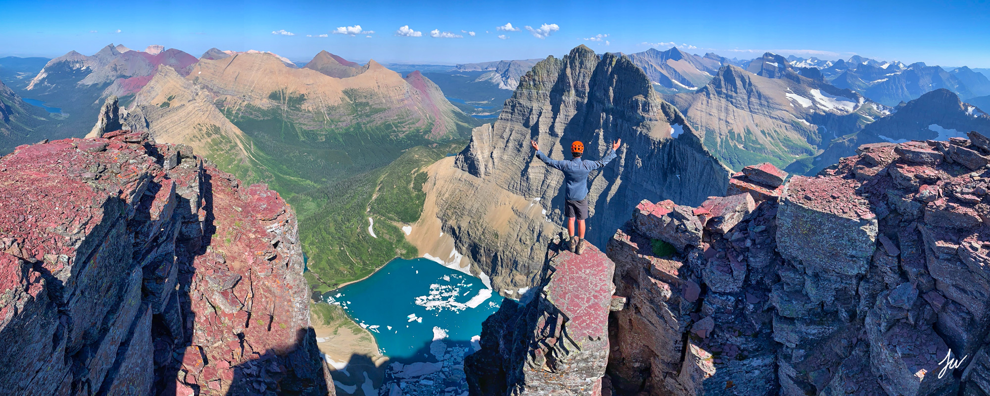
This massive mountain, the highest in Glacier NP at 10,466’, can be climbed by two routes. The standard is the west-face route. The summit views of Waterton NP, and the north part of Glacier NP are stupendous. Looking down the vertical 4,000-foot north face is awe-inspiring. It is the largest face of any mountain in the Lower 48. I have climbed Cleveland twice plus another and aborted attempt when the mountain was in total cloud.
The summit is about 13 km from Goat Haunt gaining 6100 feet.
Take the boat from Waterton Townsite to Goat Haunt the afternoon before and camp at Goat Haunt in covered shelters on cement. Leave your big packs and take daypacks from here. The destination of both routes is a waterfall on the west face. From above the waterfall, it is a simple scramble, passing cliff bands to the right, and 3500 feet to the summit. It is a gradual walk up the south ridge to the summit.
The first time I climbed Cleveland, alone, I encountered a grizzly on this ridge turning over rocks to eat the ladybugs. Five young climbers were killed in an avalanche on the west face in 1969.

Mt Cleveland from Upper Waterton Lake
a. Elk Trail Route. Using this route, climbing Cleveland is usually a two-day adventure as the bushwalk through the alder to get to the waterfall is awful. The access is up a small creek about 2.8 km from Goat Haunt. Don’t go up Camp Creek about .8 km further south, a worse bushwhack (I came down it on the aborted attempt). An elk trail can be followed but I have always lost it and ended up on the nasty 6-hour bushwack through the alder. The elk trail is easy to follow on the descent. Camp in the basin below the waterfall on the SW face.
2. Northwest Ridge. Using this route is wonderful, there is no bushwhacking and climbing Cleveland is an easier one-day trip from Goat Haunt. The ridge follows the edge of the spectacular north face of Cleveland, the highest face in the USA.
The one time I climbed Cleveland in one day (with my 9-year-old son), I took this route I had not seen described elsewhere. Shortly after leaving Goat Haunt, cross through a wet meadow to reach the obvious NW ridge of Cleveland. Walk up the ridge on a faint animal trail to ledges that traverse the west face of the mountain, and leave the ridge. It is a pleasant traverse to above the waterfall that comes down the west face.
On the descent, descend the same way or find the elk trail by descending below the waterfall (which I have been able to do the two times I climbed the mountain).
GOAT HAUNT to AKAMINA PASS
This is a three-day backpacking trip I did about 30 years ago with my 10-year-old son. It follows a trail from Goat Haunt to Boulder Pass and then goes off trail to climb the south face of Mount Forum. The valley here is spectacular with animal trails a foot deep. On the climb up Forum, we passed a difficult to reach place – a significant border marker cairn – where the continental divide meets the US/Canada 49th parallel.
Take the boat down Upper Waterton Lake to Goat Haunt. Begin on the Rainbow Falls Trail, At .9 km branch right on the Lakeshore Trail and cross the Waterton River. At .5 km beyond the bridge, the Boulder Pass Trail branches left (west). The trail rises quickly 5.6 km to Lake Janet with a small campground. Continue to Lake Francis at 10 km and camp at the Hawksbill Campsite, a short climb above the lake. A spectacular waterfall spills down from Dixon Glacier into Lake Francis. It is popular with fishermen.
Enter the subalpine at Brown Pass at 13.8 km from Goat Haunt. Brown is a wide pass with Thunderbird Mountain and its glacier to the south. Beyond Brown Pass, reach the alpine with stunning views. At 1 kilometre past the pass, we climbed 2900’ to the summit of Mt Chapman (9,406’) on an obvious route. Views of the surrounding mountains are superb and Hole-in-the-Wall campsite seems right at your feet. Lake Wurdeman lies to the north. Back on the trail, at 16.6km, a spur trail drops down to the Hole-in-the-Wall campsite in a staircase cirque carved from Mt Custer. Waterfalls pour into the basin home to a lot of wildlife. A habituated mountain goat stole clothes out of our tent! This is a spectacular place to camp.
The trail to Boulder Pass arcs high above the basin ascending through an unusual outcropping of pillow lava deposited into an inland sea millions of years ago. It is a straightforward climb up Mt Custer (8883′). From the top are great views to the north down to Cameron Lake and Waterton NP and Lake Nooney immediately below to the east. Case out the north side of Mt Forum, our destination later in the day. On the top, we saw a wolverine. Back down at the trail, cross an area glaciated in the 1960s, with many scars of glacial action. Ascend to Boulder Pass and then drop off-trail to the north down a steep slope with a good animal trail on the right down to Kintla Creek. Follow deep animal trails up the creek scouting out a route up the steep cliffs on the south face of Forum. Scramble through the cliff bands eventually reaching the prominent cement cairn marking the continental divide and the US/Canada boundary. From the cairn, scramble straight up to the top of Mt Forum. From the top drop down to the west to the immediate low point to access a game trail that switchbacks down and then continues east under the cliff forming the north face of Forum. There are steep drops down to Forum Lake. When you reach the continental divide, continue down the border cut to Akamina Pass and the Akamina Parkway. Hopefully, you have shuttled a car or arranged a pickup. Hitchhiking back to town should not be difficult.
My son never hiked with me again.
LOGAN PASS to UPPER WATERTON LAKE
This 55 km backpack starts at Logan Pass on the Going-to-the-Sun-Road, a spectacular drive that is open only a few months of the year. Built in 1933, it was considered a major feat in its day. The trail follows the Highline Trail to the west of the continental divide. Called the Garden Wall, game especially goats are often seen and we passed one sitting beside the trail. At 3 miles we climbed Mt Gould (9,553) and then continued onto Granite Park at 12 km with a chalet and campground. A deer attempted to steal clothes from our tent.
The Highline trail continues to Fifty Mountain and a campground at 29 km. It then descends 2400’ to the Waterton Valley. Another 20 km along the Waterton Valley brings you to Goat Haunt where you can catch a boat or continue on the Lakeshore Trail 13.9 km to the Waterton townsite.
ICEBERG PEAK TRAVERSE
Start at Many Glacier in Glacier NP on the Ptarmigan Trail and walk 7.6 km to Iceberg Lake. Mount Wilbur forms the huge vertical face to the south of the lake. Continue on the right side of the lake and scramble straight up a gully to the base of the great cliffs and then up a couloir to Iceberg Notch. Follow the ridge to the top of Iceberg Peak. Descend to the south, continuing south to under the North Swiftcurrent Glacier to meet the trail coming down from Swiftcurrent Pass. Return to Many Glacier.
CHIEF MOUNTAIN
Drive on the Chief Mountain Hwy 17 from Waterton. 7.2 km north of the beginning of Hwy 17, take a narrow dirt lane heading across the fields towards Chief. Drive as far as possible and park at the top of a hill. Head towards the north end of the mountain and go up the scree directly toward the great notch on the north corner of the summit ridge. Scramble up a narrow scree passageway through the notch. Walk onto the east face on a distinct climber’s trail toward the south reaching the top of the summit ridge in 10 minutes. Walk south on the ridge top 250 m to the summit cairn. Negotiate a 9’ notch with some exposure and an easy solid chimney up the last 15-foot cliffs just north of the summit cairn. Since I last did this a huge portion of the cliff fell off so the route may have changed.

