CHINA November 2014
This was my first trip to China. I flew from Xian to Jiuzhaigou Airport. A 40 km bus stopped for 4 hours in Huanglong National Park and continued to Jiuzhalgou NP making it very convenient to see both in one day. Both these parks are expensive with a 220¥ entrance fee. Add 80¥ for the cable car in Huanglong and 90¥ for the bus in Jiuzhalgou, and each visit costs $50. The ‘trails’ in both parks are constructed boardwalks. Despite that, this is spectacular nature and worth the time and money. Both are Unesco World Heritage listed.
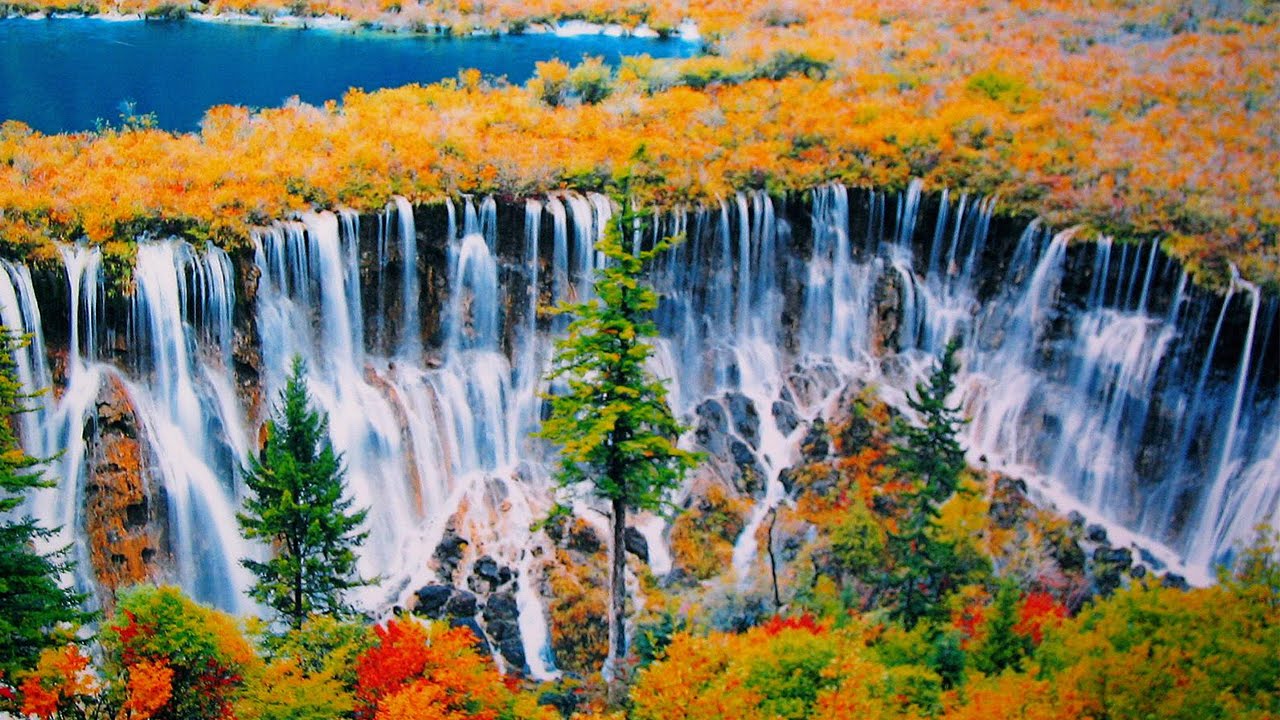
HUANGLONG NATIONAL PARK
It is located in the southern part of the Minshan mountain range, 370 kilometres north-northwest of Chengdu. This area is known for its colourful pools formed by calcite deposits, especially in Huanglonggou (Yellow Dragon Gully), as well as diverse forest ecosystems, snow-capped peaks, waterfalls and hot springs. Huanglong is also home to many endangered species including the giant panda and the Sichuan golden snub-nosed monkey. Huanglong was declared a World Heritage Site in 1992.
We caught the cable car up the mountain. From the cable car is a level boardwalk at 3560m. It climbs minimally around a high lake and then descends the valley past a stunning collection of small, terraced travertine ponds containing bright blue and turquoise water.
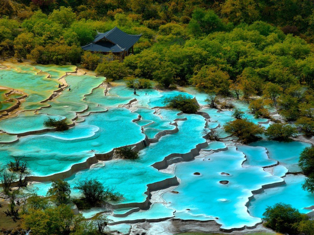
The yellow rock often cascades down long slopes and the water falls over 10m travertine waterfalls. We took 4 hours to make the circuit down the valley. Taking the cable car was necessary.
The forest is a great mix of large pine, larch and cypress trees, and rhododendrons and azaleas, that bloom in the spring and summer.
JIUZHALGOU NATIONAL PARK
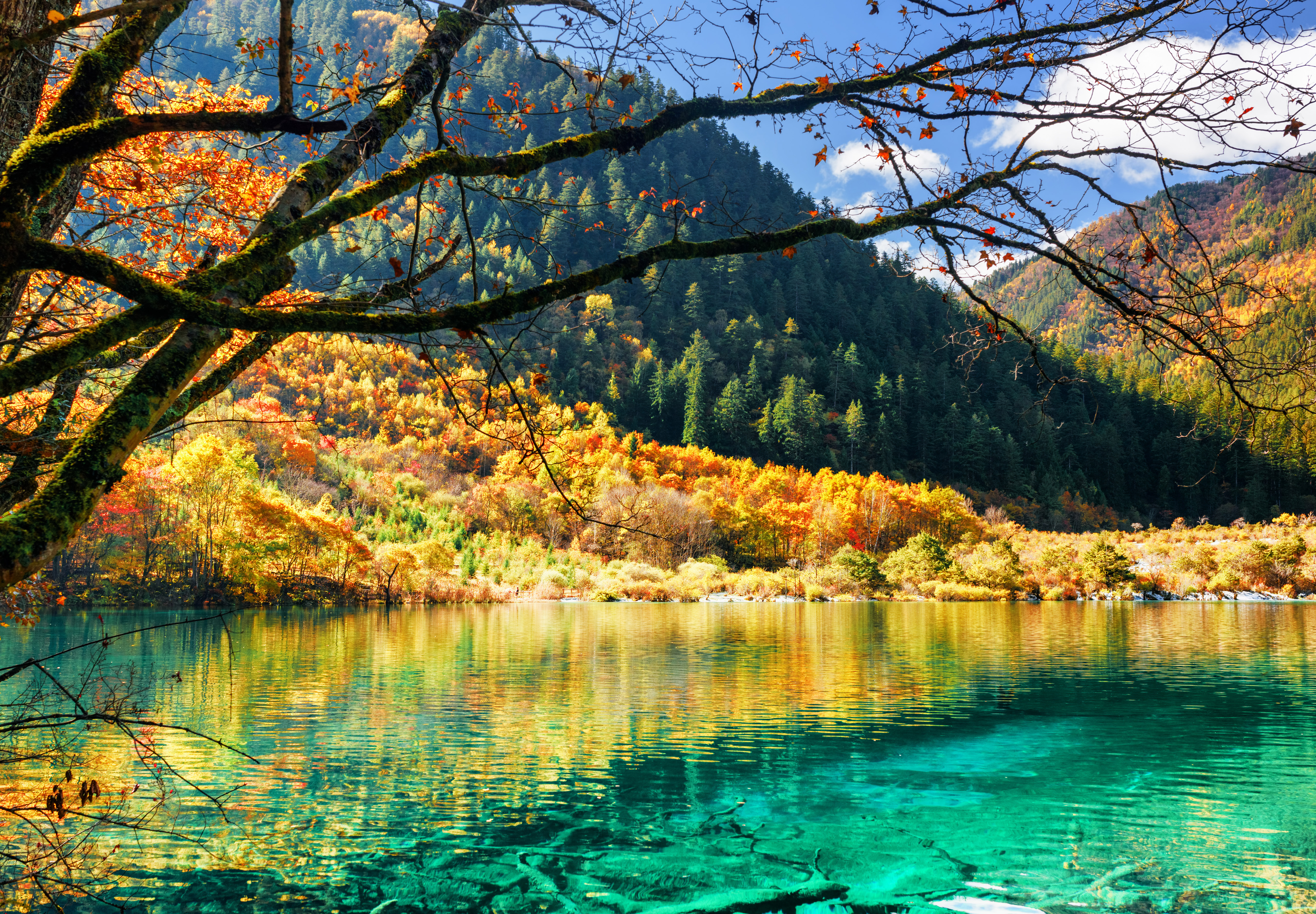
We then had a 3-hour drive to Jiuzhalgou. The major ethnic group here is Tibetan with traditional 2-story houses decorated classically. Buddhism reigns supreme with stupas and prayer flags concentrated in the villages. There were originally nine Tibetan villages (Jiuzhalgou means ‘Nine Village Valley) here but now only three are inhabited. Summer is busiest but October is the best time to see fall colors at their peak.
There are many hostels near the national park entrance. I lucked out and stayed in a room with two great young Chinese men with good English. One booked my bus to Chengdu and I spent the entire day hiking with the other in Jiuzhalgou. Gordon was an intelligent, well-read guy with a great worldview. I had a chance to explore all sorts of Chinese cultural issues. he stated that he thought China was more successful than other BRIC countries because Chinese were much more hard-working.
We were up at 05:30 to have breakfast and get to the entrance before 07:00 when tickets go on sale. The line-ups can be prodigious and as this was a Sunday, crowds were anticipated to be huge. This is the most popular national park in China. My ticket was half-price (age 60-69) and they are free if over 70. I forgot to ask at Huanglong.
We were on the first bus. The buses are hop-on-hop-off and have a video that gives a complete tour-guide experience talking about the park and each attraction as you pass it with stilted English subtitles. After about 14 km, the road splits. The western side has many more attractions.
The mountains and trees were covered in fresh snow with the peaks obscured. Because of the snow, we were let off at Arrow Bamboo Lake and started walking in 3” of snow. You then pass a series of perfect turquoise lakes and waterfalls. At Mirror Lake, descend to the fantastic 300 m-long Nourilang Waterfall that drops 15m over a shelf of travertine.
It is a short walk up to the Nourilang junction to catch the bus up the eastern valley, 18 km to Long Lake. Again in the snow, it was a short walk down to Colored Lake also deep turquoise. The crowds were massive by this time. Walk down to another bus stop for the drive back to the junction then the 14 km back to the park entrance. Pass two Tibetan Villages, many-coloured lakes, and waterfalls to the rushing Zechawa River on the boardwalk. It was a long walking day in one of the more beautiful parts of the world. I don’t believe there are lakes like this anywhere else.
A comparable place is Havasu Creek, west of Grand Canyon National Park in the Havasupai Indian Reservation in Northern Arizona. It has two much higher waterfalls, the same turquoise water, travertine, and a gorgeous eight-mile hike to the Colorado River, but no lakes or ponds. The intense colour of the water is also comparable to many of the geyser fields in Yellowstone.
Travertine is a form of limestone deposited by mineral springs, especially hot springs. Travertine exists in white, tan, cream-coloured, and even rusty varieties. It is formed by the rapid precipitation of calcium carbonate from solution in ground and surface waters. Supersaturated alkaline waters degas CO2 increasing pH. Since carbonate solubility decreases with increased pH, precipitation is induced.
In a limestone cave, it can form stalactites, stalagmites, and other speleothems. Macrophytes, bryophytes, algae, cyanobacteria, and other organisms often colonize the surface of travertine and are preserved, giving travertine its distinctive porosity. Tufa is similar but softer and extremely porous and forms in ambient-temperature water. Some springs have temperatures high enough to exclude organisms and are less porous than tufa.
When pure and fine, travertine is white, but often brown to yellow due to impurities.
Travertine is often used as a building material. The Romans mined travertine for building temples, aqueducts, monuments, bath complexes, and amphitheatres such as the Colosseum, the largest building in the world constructed mostly of travertine. Other notable buildings using travertine extensively include the Sacré-Cœur Basilica in Paris, the 20th-century Getty Center in Los Angeles, California, and Shell-Haus in Berlin. These latter two used imported travertine from Tivoli and Guidonia in Italy.
Travertine is one of several natural stones used for façades, wall cladding, and flooring especially paving patio and garden paths. The relative softness of the stone, combined with its pitted holes and troughs, make travertine flooring difficult to finish and maintain
Italy had a near-monopoly on the world travertine market but now significant supplies are quarried in mainly Turkey, Iran, Mexico and Peru. Two or three small travertine producers operate in the western United States. U.S. demand for travertine is about 0.85 million tons per year, almost all imported.
DRAGON’S BACKBONE RICE TERRACES
Transportation: Bus to Guilin, city bus to the Qintan Bus Station, bus to Longsheng but get off at Heping, bus to the bottom of Ping’an turn off, and then hitchhiked 6 km up the hill in the back of a truck carrying freshly cut wood with a great aroma. Hotels have direct buses leaving from the Guilin train station at 08:00-09:00
The people here are Zhuang, all with the last name of Liao. The women wear pink or blue towels as extravagant hats and simple black tops with embroidered sleeves and black pants. It was a long walk up the hill to the International Youth Hostel. Mules are the beasts of burden in the town which has no car access.
In the neighbouring towns live the Yao; the women dress traditionally – the hair-do is fascinating – the floor-length hair is wrapped tightly concentrically around their head and brought to the front in a bun and then covered with a turban-like black cloth. Heavy silver earrings stretch the hole and greatly lengthen the lobe. The rest of their clothing is black with a pink and blue embroidered top, colourful sash, black skirt and leggings. They are old, short and very cute. The terraces rise to 1000m high surrounding Ping’an and are a major engineering feat. The irrigation system is intriguing. Tiny cement canals carry water in the terraces.


The next morning at 7:30 I left to do the wonderful 4-hour hike through the rice terraces and the minority villages of Zhongliu and Tiantouzhal arriving at Dazhai. Start uphill to the Seven Stars with the Moon viewpoint and crosse the top of the terraces to the Nine Dragons and Five Tigers viewpoint. Turn left to a cement road and follow the road uphill. It becomes rough gravel, goes over a small dam and eventually turns into a path through a cemetery and some rice paddies. The graves are randomly built into the banks and have an elaborate lintel over a small stone door covered in characters. I presume they tell the life story of the deceased. Eventually, the path climbs up to a viewpoint where one can see the route ahead meandering through rice terraces, and the rooftops of Zhonglu village before going over a small pass towards Dazhai.
For many reasons, I decided to turn around. The schematic map was not to scale and I thought I’d have difficulties getting a bus to the Ping’an turnoff, the 6km road up the mountainside to walk up to the hostel to get my pack and walk back. When it started to rain, it was an easy decision.
With my pack, I walked down the 6 km road, put my thumb out and got a ride with an old guy on a motorcycle. At the bottom, I gave him 20¥ and asked if he was going to Heping. In Heping, I gave him another 10¥, he gave a big smile and patted his gas tank. We were both happy. The best 5 bucks I have ever spent!
While waiting for the bus to Longsheng, I hitchhiked again with a young couple with just enough English to make it fun. They dropped me off at the Longsheng bus station and I got the bus to Sanjiang waiting only 25 minutes. Sangiang is on the border with Hunan province to the north.
Chengyang Wind and Rain Bridge. 19 km from Sangiang in the village of Maan, this 78m long bridge is the grandest of more than 100 nail-less bridges in the area built by the Dong people (they are renowned carpenters) at the turn of the last century. Built from fir logs, it took 12 years to knock together and is a picture of poetic engineering.

The bridge has 5 typical Chinese buildings joined by covered walkways, walls and benches, offering good protection against the elements. There are 8 Dong villages, 5 Dong wind and rain bridges, 8 drum towers and traditional Dong homes in the area to visit. Nearby is another small bridge with a great bamboo water wheel. It costs 60¥ to enter the area.
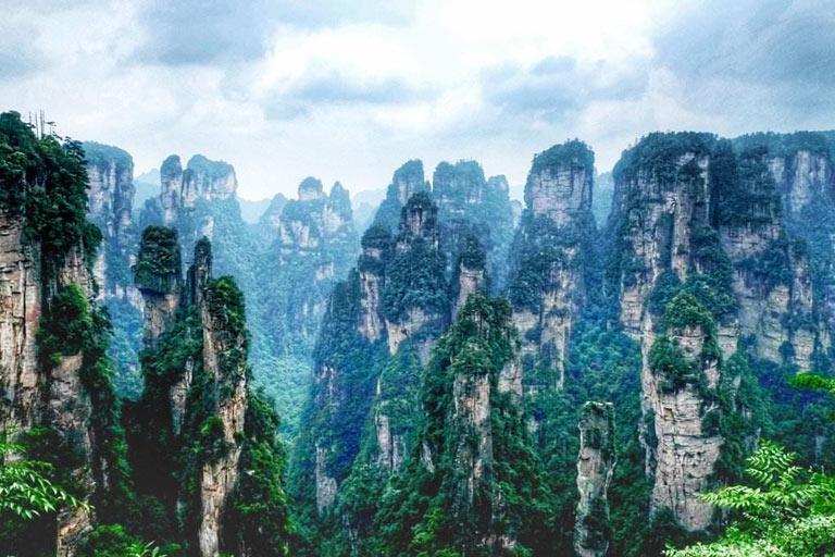
ZHANGJIAJIE NATIONAL PARK (Wulingyuan)
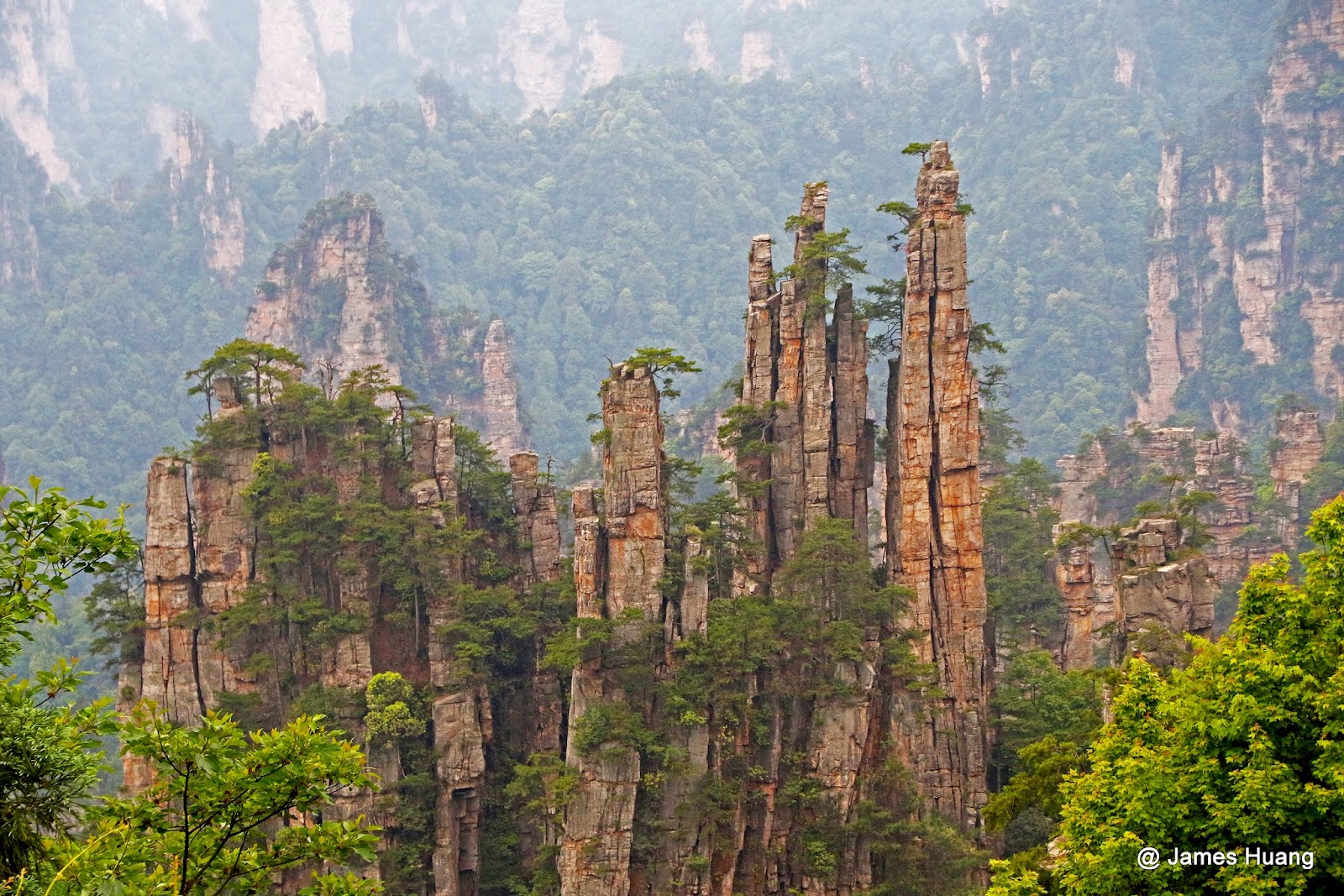
Declared a Unesco World Heritage Site in 2004, this 364 sq. km park in the subtropical/temperate area of northwest Hunan has a concentration of quartzite-sandstone formations found nowhere else. Some 243 peaks and more than 3000 pinnacles and columns dominate the landscape. 198 columns are 200-300m high and 48 are over 300m high. Jinbian Rock is the highest at 380m. The 15km long Jinbian Brook has the highest concentration of columns with 400.
The columns of rock are formed by tectonic forces and water weathering. Although resembling karst terrain, this area is not underlain by limestones and is not the product of the chemical dissolution characteristic of limestone karst. They result from many years of physical, rather than chemical, erosion, most from expanding ice in the winter and the plants that grow on them. They rise almost square in shape straight up from the valley floors. The weather is moist year-round, and as a result, the foliage is very dense. It is home to a wide biodiversity of plants and animals including macaques, giant salamanders and clouded leopards. 20 million visit the park annually.
One of the park’s quartz-sandstone pillars, the 1,080-metre (3,540 ft) Southern Sky Column, was officially renamed “Avatar Hallelujah Mountain” in honour of the film in January 2010.
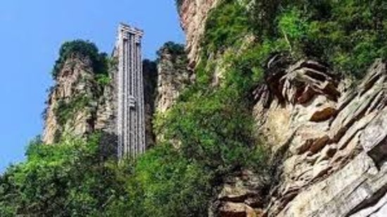
The towering Bailong Elevator, literally ‘hundred dragons sky lift’, was opened in 2002. At 326 m (1,070 ft), it is the world’s tallest outdoor lift. It can transport visitors to the top from its foot in less than two minutes. Three separate glass elevators can each carry 50 people at a time.
In 2016, Zhangjiajie Grand Canyon opened the Zhangjiajie Grand Canyon Glass Bridge, the longest (430) and highest (300 m) pedestrian glass bridge in the world. Thirteen days after opening, the bridge was closed due to the sheer number of visitors. It reopened on the 30th of September 2016 after adjusting the logistics and safety measures for handling large numbers of tourists.
I picked an unfortunate day to go as it was raining, cold, windy and everything was obscured by cloud. However, I also avoided the hordes of people and saw virtually no one. It often rains here and even on good days, mist and fog obscure the sights.
I caught a bus from the station five minutes from my hotel. The bus arrived at the main south entrance. The exorbitant 245¥ entry is 50% less for seniors over 60, and is good for three days.
The park is divided into four scenic areas.
1. Huangshi Village. From this entrance, the part accessed is a 16-hectare plateau 1068m above the canyon floor. Walk up the 3878 steps or use a bus and a cableway (65¥, 40¥ for seniors over 60). A 3.5km stone pathway travels the circumference of the plateau with viewpoints to many of the amazing rock formations, none of which I saw in the whiteout conditions. It was a walk in the woods. The path had an elaborate cement “wood fence”. Every “cut” surface had a clay-like covering painted intricately with the rings of a tree – over the top or what!

I took the stairs down and passed many rock towers and columns. By now it was raining heavily so I headed back to Zhangjiajie City.
2. Golden Whip Stream Scenic Route. From the south entrance, it is also possible to walk 7.5km into the centre of the park. Coming off this to the south is 3. Baiying Valley.
The next day, I returned and took a bus to the Wulinyuan Entrance on the park’s east side to see the other two big areas. I caught a bus to the Bailong Sky Lift, a cliff-side elevator that rises 335m to access the
4. Yuanjiajie Scenic Area in the middle of the park. The viewpoints from the top of the elevator look over a sea of columns. After the elevator is a 5-minute walk, then an 8-minute bus ride through a boring bit before coming to a walk on the edge of a cliff with Shadao Stream more than 300m straight down. The clouds and mist cleared enough to get good views of the fantastic columns. A natural bridge 300m above the floor is crossed at one point.
I then boarded a bus with several possible stops:
5. West Yuanjiajie Scenic Area
6. Laowuchang Valley
7. Dagyandal Valley and finally
8. Tianzi Mountain. From a central area, one can walk along a more challenging ridge.
At the south end is a glass plank suspended over the cliff face and an escalator to Tianmen Cave, a huge arch continuing to the valley floor. The other option is the Tianzi Cableway which descends through fantastic columns to the main road and the bus that returns to the Wulinyuan Entrance. The top was socked in, raining and cold, and I opted for the cableway to return to Zhangjiajie City and my comfy hotel room.
There are easily three full days of hiking available in Zhangjiajie National Park. Crowds were large on this rainy, cold, no-view Tuesday in late November. I can only imagine what they might be like on a weekend in peak season with a nice day. The ethereal landscape here is not to be missed. Nothing else like it exists in the world.
I don’t think I have seen so many signs with stilted English as in this park. The signs are large wood billboards, rocks with incised letters and other expensive productions. Brochures are poorly translated. Names of viewpoints and natural features are very poetic. There was an unfortunate amount of garbage littering the trees below the cliffs despite many garbage cans. Trails are also littered with signs warning of dangers: slippery paths, rockfalls, and falling into creeks. Chinese need a lot of babysitting. Everything has a long list of rules of behaviour and problems. A small bench swing on the Yangzi tour boat had 6 instructions on safe use! Maybe they find Chinese as non-intuitive as I do.
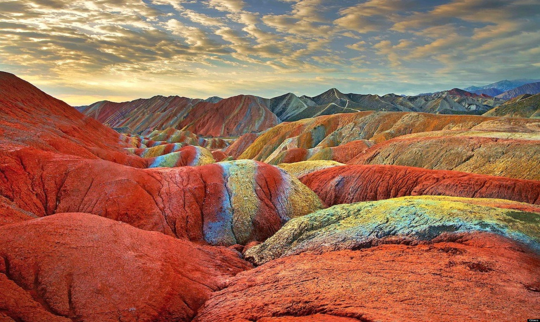
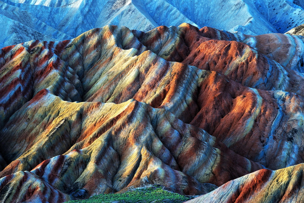
Near Zhangye, Gansu Province, I saw Danxia Rocks National GeoPark – six multicoloured rock formations recently inscribed as Unesco World Heritage Sites. The swirling rainbow palette and the scale of the formations are lovely. These are mudstone/flowstone formations – clay-based soft earth in layers. The area is like Dante’s Viewpoint in Death Valley NP (the surrounding mountains are also similar) and the colours are similar to the Bentonite Hills of Capital Reef NP or the hills around the Paria townsite area. A shuttle bus takes you between four viewpoints. A taxi is the only way to get there.