
Karst is a topography formed from the dissolution of soluble carbonate rocks such as limestone, dolomite, and gypsum. It is characterized by features like poljes above and drainage systems with sinkholes and caves underground.
Subterranean drainage may limit surface water, with few to no rivers or lakes. Buried karst in the stratigraphic column is important in petroleum geology as about 50% of the world’s hydrocarbon reserves are hosted in carbonate rock, and much of this is found in porous karst systems.
Karst develops in dense carbonate rock like thinly bedded and highly fractured limestone. Karst will not develop in chalk, as chalk is highly porous rather than dense, so groundwater flow is not concentrated along fractures. Karst develops where the water table is relatively low, such as uplands with entrenched valleys, and where rainfall is moderate to heavy. This contributes to the rapid downward movement of groundwater, which promotes dissolution of the bedrock,
Chemistry of dissolution. The carbonic acid that causes karst forms as rain passes through Earth’s atmosphere picking up carbon dioxide (CO2), which readily dissolves in the water. Some of the dissolved carbon dioxide reacts with the water to form a weak carbonic acid solution, which dissolves calcium carbonate. The oxidation of sulphides leading to the formation of sulfuric acid can also be one of the corrosion factors in karst formation.
Morphology. The karstification of a landscape may result in a variety of large- or small-scale features both on the surface and beneath it.
On exposed surfaces, small features may include solution flutes, runnels, limestone pavement, kamenitzas collectively called karren or lapiez.
Medium-sized surface features may include sinkholes or cenotes (closed basins), vertical shafts, foibe (inverted funnel-shaped sinkholes), disappearing streams, and reappearing springs.
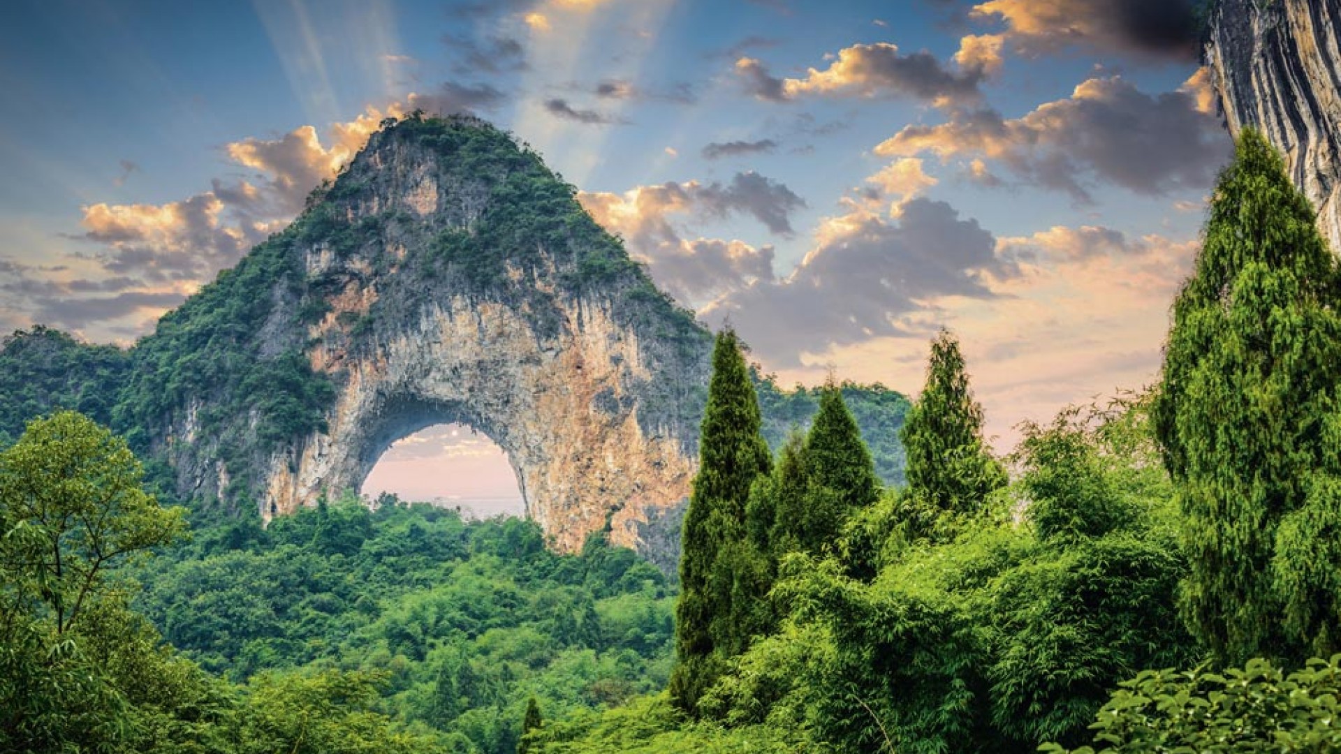
Large-scale features may include limestone pavements, poljes, and karst valleys. Mature karst landscapes, where more bedrock has been removed than remains, may result in karst towers, or haystack/eggbox landscapes.
Erosion along limestone shores in the tropics, typical karst topography includes Thailand’s Phangnga Bay and Halong Bay in Vietnam.
Beneath the surface, complex underground drainage systems (such as karst aquifers) and extensive caves and cavern systems may form.
Calcium carbonate dissolved In water may precipitate out where the water discharges some of its dissolved carbon dioxide. Rivers that emerge from springs may produce tufa terraces, consisting of layers of calcite deposited over extended periods. In caves, a variety of features collectively called speleothems are formed by deposition of calcium carbonate and other dissolved minerals.
Kegelkarst, salt karst, and karst forests. Kegelkarst is tropical karst terrain with numerous cone-like hills, formed by cockpits, mogotes, and poljes without strong fluvial erosion processes. This terrain is found in Cuba, Jamaica, Indonesia, Malaysia, the Philippines, Puerto Rico, southern China, Myanmar, Thailand, Laos and Vietnam.
Karst areas tend to have unique types of forests. The karst terrain is difficult for humans to traverse, so ecosystems are often relatively undisturbed. The soil tends to have a high pH, that encourages the growth of unusual species of orchids, palms, mangroves, and other plants.

Aquifers. Karst aquifers typically develop in limestone. Surface water containing natural carbonic acid moves down into small fissures that lead to progressive enlargement of openings forming a conduit system that drains the aquifer to springs. Groundwater flow rate in karst aquifers is much more rapid than in porous aquifers. Groundwater in karst areas is easily polluted as Karst formations are cavernous and highly permeable, resulting in reduced opportunity for contaminant filtration.
Farming in karst areas must take into account the lack of surface water. The soils may be fertile enough, and rainfall may be adequate, but rainwater quickly moves through the crevices into the ground, sometimes leaving the surface soil parched between rains.
SOUTH CHINA KARST A UNESCO World Heritage Site since June 2007, this spans the provinces of Chongqing, Guangxi, Guizhou, and Yunnan. It is noted for its karst features and landscapes unrivalled in diversity. The region is recognized as the world’s type area for karst landform development in the humid tropics and subtropics. There are many large cave systems with rich speleothem deposits.
The region can be considered the global type-site for three karst landform styles: fenglin (tower karst), fengcong (cone karst), and shilin (stone forest or pinnacle karst). The landscape also retains most of its natural vegetation. It constitutes one of the planet’s great landscapes.
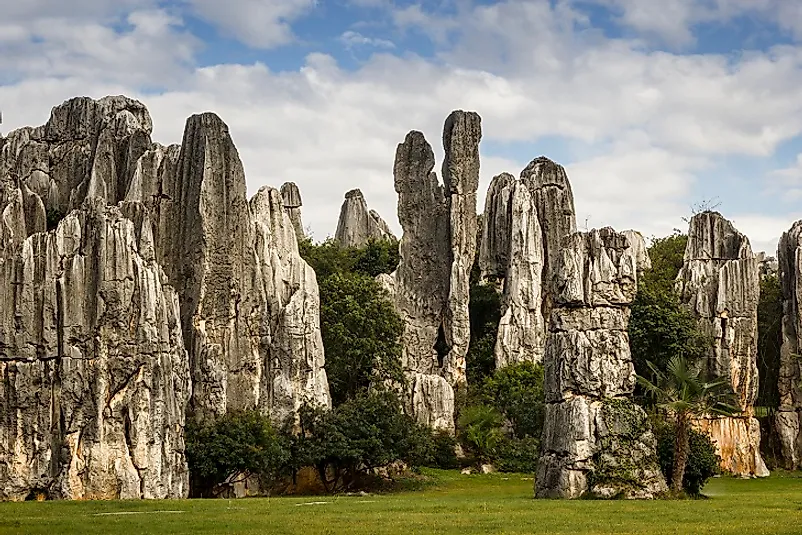
Lunan Stone Forest, Yunnan. Near Shilin and approximately 90 km from the provincial capital Kunming, the tall rocks rise from the ground like stalagmites or petrified trees creating the illusion of a forest made of stone.
They are caused by the weathering of limestone that started as a shallow sea over 270 million years ago. Deposits of sandstone overlain by limestone accumulated in this basin. Uplift and later, exposure to wind and running water shaped these limestone pillars. Macroscopic fossil remains are seldom seen.


GUIZHOUU KARST LANDSCAPES
Guizhou has been labelled as egg-box topography – crowded sharp summits with intervening depressions largely devoid of integrated valley systems.
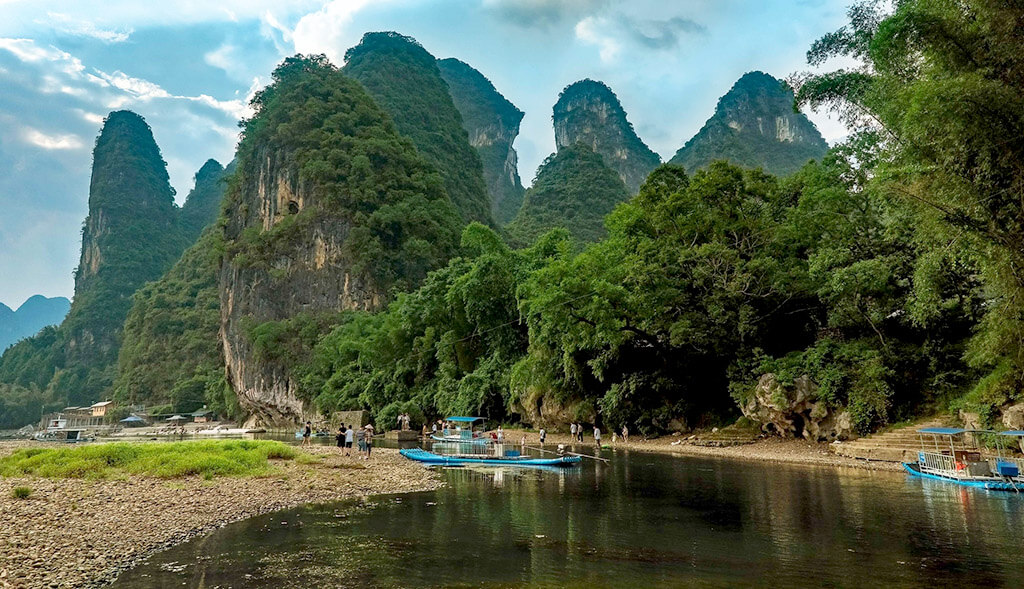
Li River 2½ hour boat ride on the way to Yangshou for 280¥. The half-hour bus ride turned into an hour and a half on pot-holed dirt roads to the river and the small bamboo boats (actually plastic that looked like bamboo). We put-putted down the river at a snail’s pace through magnificent karst scenery of cliff faces, pinnacles and towers. The Chinese 20¥ bill has a scene from the river. After the boat ride, we boarded 10-passenger golf carts to Xingping and then a bus to Yangshuo.
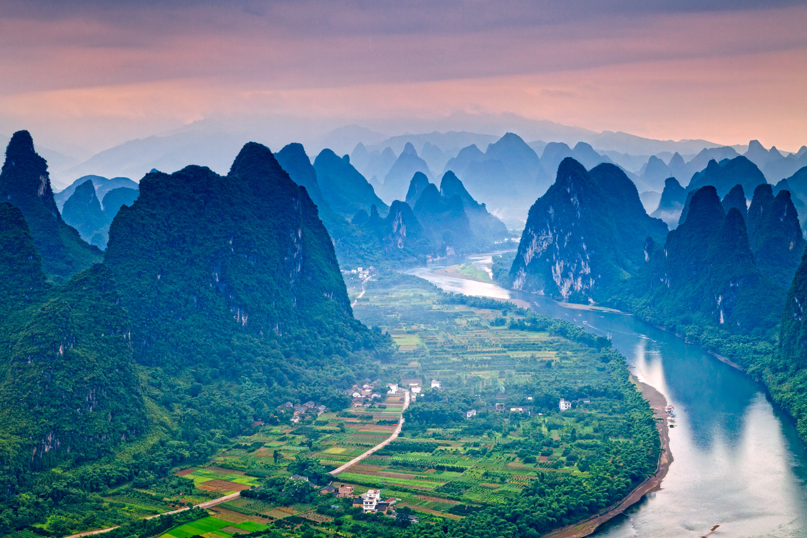
Xingping is 27 km upstream from Yangshuo on the Li River. A prominent peak overlooks the village, topped with a lookout that can be climbed.
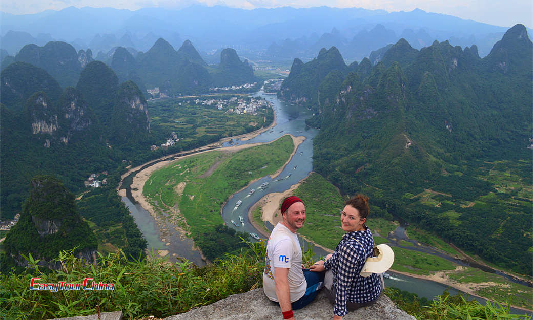
Yangshou (pop 310,000) has karst towers much closer than in Guilin.

Zhijin Cave (near Minzhai Village, 120 kilometres from Guiyang) is a huge cave with 150 scenic spots, 19 halls and 49 open chambers. The average height of the cave is 46 meters and the highest spot is 168 meters and is noted for its stalactites, stalagmites, and the clear blue water in its lakes, rivers and waterfalls.
More than 12 kilometres long, the largest hall is 173 meters wide and 150 meters high. It is like a vast underground palace with a superb array of karst formations – stone curtains, stalactites, stalagmites, stone pillars and stone flowers. The “Silver Rain Tree” is a 17-meter-tall rare flower-like transparent crystal; the gold silver tower.


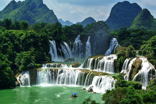
Guizhou: the Land of Waterfalls
Huanggoushu Waterfall: Asia’s Largest Waterfall is 47 kilometres south of Anshun City and 137 kilometres from Guiyang – 77.8 meters high, and 101 meters across. In the middle of the falls, water cascades over a cliffside cave, which can be reached on a slippery trail for an inside view of the falls.
There are 18 minor but equally beautiful waterfalls (Luositan Waterfall, Silver-Chain Waterfall and Dishuitan Waterfall) included in the Guinness Book of World Records in 1999 as the world’s largest waterfall cluster. Huangguoshu Waterfall is the only waterfall in the world that can be viewed from above, below, front, back, left and right


Guanling Waterfall on the Baling River Canyon has seven grades with a total fall of 410 meters. Each grade has its special features and charms.

Na Daguan Waterfall has 18 grades over 140 meters.


Getu River Scenic Spot is on the upper reaches of the Hongshui River 76 km from Anshun, It has suspension coffins, tombs in caves, ethnic customs and lifestyle. and the world’s second-largest underground chamber.
Xiangshuidong Cave at 215m has the last troglodytism tribe in human history — Miao Village in Zhongdong Cave. The cliffs along both sides of the Getu River are home to the hanging coffins of the Miao people. Thousands of ancient coffins are in the caves on the cliffs.


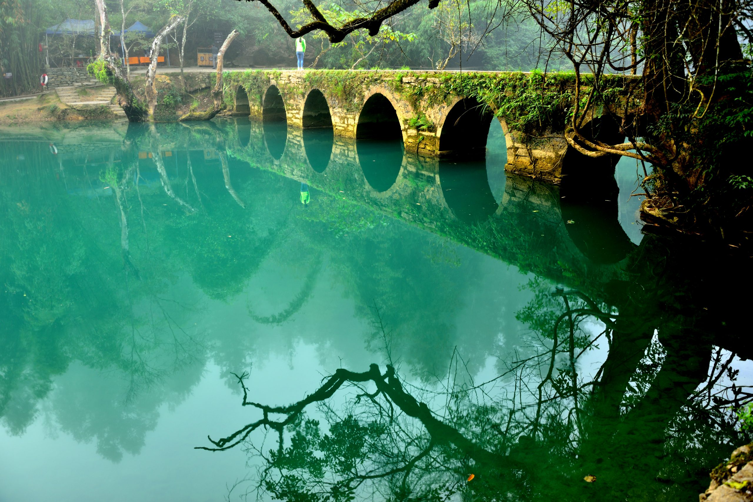
Libo Zhangjiang Scenic Spot (Libo County, 120 kilometres south-southeast of Guiyang) has the Small Seven-hole Bridge, Large Seven-hole Bridge, Shuichun River Scenic Area and Zhangjiang River Scenic Area with a wide array of waterfalls, streams, lakes, forests, fantastic caves and the ethnic cultures of the Shui, Bouyei, Miao and Yao people.
.
Maolan (in Libo County) is in a beautiful karst area. There are many ethnic groups living here, including Bouyei, Shui and Yao. Maolan Karst Nature Reserve has forest covering 91.6 percent, 500 kinds of trees, wild animals, virgin forest, karst caves and waterfalls.

THAILAND KARST
Phang Nga Bay is a 400 km2 bay in the Andaman Sea in southern Thailand of limestone cliffs with caves, collapsed cave systems, and archaeological sites. Around 10,000 years ago, when sea levels were lower, one could walk from Phuket to Krabi.
Phang Nga is a shallow bay with 42 islands, comprising shallow marine waters and intertidal forested wetlands, with at least 28 species of mangrove; seagrass beds, coral reefs and 88 bird species.

Krabi


VIETNAM
TAN LO CAVE About 100km north of the National Park is an amazing karst landscape of sheer walls, broken ridge lines and karst pinnacles. This was a 2-day/1-night tour that involved swimming through several caves. We wore a life jacket and had a waterproof pack with our stuff that provided flotation.
Day 1. Hung Ton Cave had a big drop with a ladder and then a long swim. After swimming across a river, we entered Kim Cave, discovered first in 2012. This one involved 3 moderate swims. After a long hike, we entered Tan Lo Cave with wonderful formations – large draperies, soda straws, and marvellous fern-like formations. This was a hike in and out with no swimming. We camped outside Ken Cave with its rushing waterfall. Sleeping was in a hammock and I was out for 11 hours.
Day 2. The Polish couple on the trip got into the rice moonshine and were so hung over the next morning, they skipped the Ken Cave. After a 200m swim, we explored another half-kilometre dry cave with some good formations at the end and then had the same swim back. It was a rough hike back across rugged karst mountains.
The guide, food, caves and company were all excellent and well worth the expensive $250 cost. We crossed many flat fields on the way back – all cultivated for crops other than rice. It seems women do all the work and men ride around on motorbikes, play cards and checkers, and drink rice wine. After the fields were plowed they broke up the clods by standing on a simple frame of 2 boards pulled by a water buffalo.
PHONG NHA KE BANG National Park has a pristine jungle with over 90% primary forest and hundreds of caves in the oldest karst landscape in SE Asia, including the largest cave in the world.
I went on a one-day national park tour. We stopped at several roadside viewpoints to see the amazing landscape and get a full run-down on how the war was fought in this area. It was the start of one of the Ho Chi Minh trails. The area was heavily bombed and defoliated with Agent Orange but seems to have recovered except for large amounts of unexploded ordnance.
Paradise Cave has a boardwalk through the first 1 1/2 km displaying marvellous formations in this huge cave.

Dark Cave, Named for the harder black limestone forming most of the walls. After a kayak ride to access the cave, we had a short wade to a narrow side canyon. We waded through and climbed over several hundred yards of wet mud up to our mid-thighs and then returned the same way.

I think the guides wanted us to start a mud fight but few took the bait. It was then a swim out and back in a big pool to wash off all the mud.
SO’N DOÒNG CAVE. Located near the Laos–Vietnam border, Hang Sơn Đoòng is the largest known cave passage in the world by volume. It has an internal, fast-flowing subterranean river.
Hang Sơn Đoòng was founded by a local man in 1991. The whistling sound of wind and the roar of a rushing stream in the cave is heard through the entrance. The steep descent prevented the local people from entering the cave.
Only in 2009 did the cave become internationally known after a group of cavers from the British Cave Research Association surveyed Phong Nha-Kẻ Bàng. Their progress was stopped by a large, 60-metre (200 ft) high flowstone-coated wall, which was named the Great Wall of Vietnam. It was traversed in 2010 when the group reached the end of the cave passage.
The main Sơn Đoòng cave passage is the largest known cave passage in the world by volume – 38.4×10⁶ cubic metres. It is more than 5 kilometres long, 200 metres high and 150 metres wide. Its cross-section is believed to be twice that of the next largest passage, in Deer Cave, Malaysia.
It has 2 large dolines, areas where the ceiling of the cave has collapsed and allows sunlight to enter resulting in the growth of trees.
The cave contains some of the tallest known stalagmites in the world, up to 70 m tall and cave pearls the size of baseballs, an abnormally large size.
In early August 2013, the first tourist group explored the cave on a guided tour at a cost of US$3,000 each. Permits are required to access the cave and are made available on a limited basis, with 1000 permits available for the 2019 and 2020 seasons, which runs from February to August. As of 2017 only Oxalis Adventure Tours have permission to enter the cave for tourism purposes. (Maybe this cave is open now without the expensive tours).
CAT BA ISLAND
Cat Ba Island is about 35 km south of Halong Bay. It is a national park and has a much more relaxed pace than the heavily commercialized Halong Bay.
I had an amazing series of transportation links without a 30-second delay – a motorcycle to Leong Yen Bus Station, a 2-hour bus to Haiphong (the third largest city in Vietnam), a motorcycle to Ben Binh Harbour, a bus 30 minutes south to Dinh Vu, 30-minute fast boat to Cat Ba Island and another 30-minute bus across the island to Cat Ba Town.
Cat Ba Island is rugged, craggy and jungle-clad. The island is Vietnam’s adventure and ecotourism centre. It was declared a National Park in 1986 to protect the rare golden-haired Langur, the world’s rarest primate, Cat Ba is a nice alternative way to see the karst formations of Halong Bay, one of the New Seven Natural Wonders of the World, while avoiding all the dodgy scams involved in seeing the bay from Halong City.
Lan Ha Bay has 300 karst islands, an extension of Halong Bay but with beaches, fewer people, and less trash. I went on a one-day boat tour of the bay visiting a cave that wound through an island, kayaking, and swimming. The forested, vertical-walled karst islands are quite spectacular
.
Halong Bay


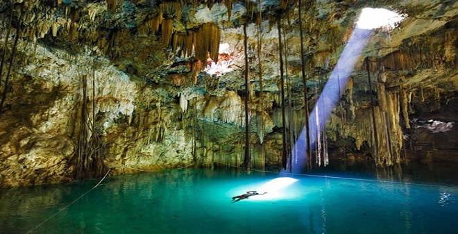
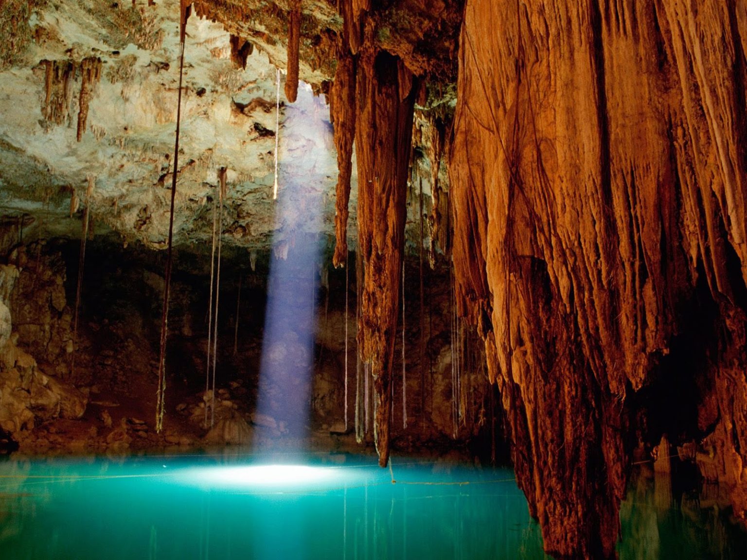
Cenotes are deep underground sinkholes in the world’s largest underground river system. The Yucatan is flat and low and is made of limestone bedrock that allows the rainwater to filtrate the soil allowing underground lakes and rivers. They are former caverns whose roofs have caved in. Their water is unbelievably clear and may have stalactite and stalagmite formations making them a favourite for divers and snorkelling. Bring a mask and snorkel to see all the rock formations and fish.
The Maya used the cenotes as precious and unique water sources and as sacred places for their religious ceremonies. It was the residence of the gods, who had direct influence over human affairs. Perhaps none of the area’s features was of more sacred importance than the cenotes, the distinct Yucatán sinkholes where the ancients believed it was possible to commune with the rain god Chaac.
Some 6,000 of these cenotes, whose name derives from the Mayan ts’onot, cover the peninsula, an abundance partially owed to the geological impact of the dinosaur-destroying Chicxulub asteroid that hit the area 65 million years ago. Mayan settlements were typically established in the vicinity of cenotes, for both practical purposes, namely a water source, and ritual purposes, such as sacrificial offerings to Chaac and calculation of harvests.
Getting there. Cuzamá may be reached by a 1.5-hour bus that departs from the Noreste terminal in Mérida, but travel by car is recommended. The cenotes are open daily from 8:00 a.m. to 5:00 p.m.; the last cart leaves the departure point at 3:30 p.m. The price for a ride on the cart, which carries four people was 300 pesos (but may be more now).
Three completely separate cenote complexes around Cuzama are run by three different cooperatives: X’Tohil, Cuzama, and Chunkanán. It’s easy to get them confused with one another. All three Cuzama cenote cooperatives provide similar experiences with a horse-pulled cart ride, yet they visit different cenotes. Competition is fierce and you’ll experience people flagging you in as you approach.
The Cuzumá cenotes are in a remote jungle area distant from the idyllic town. Getting there is half the fun. Pari and arrive at the Decauville train track system – rickety, crooked, and narrow (2’) rail lines with mall railway trolleys pulled by horses. If you meet another car, one of them must unload and hoist the car off the tracks to let the other pass.
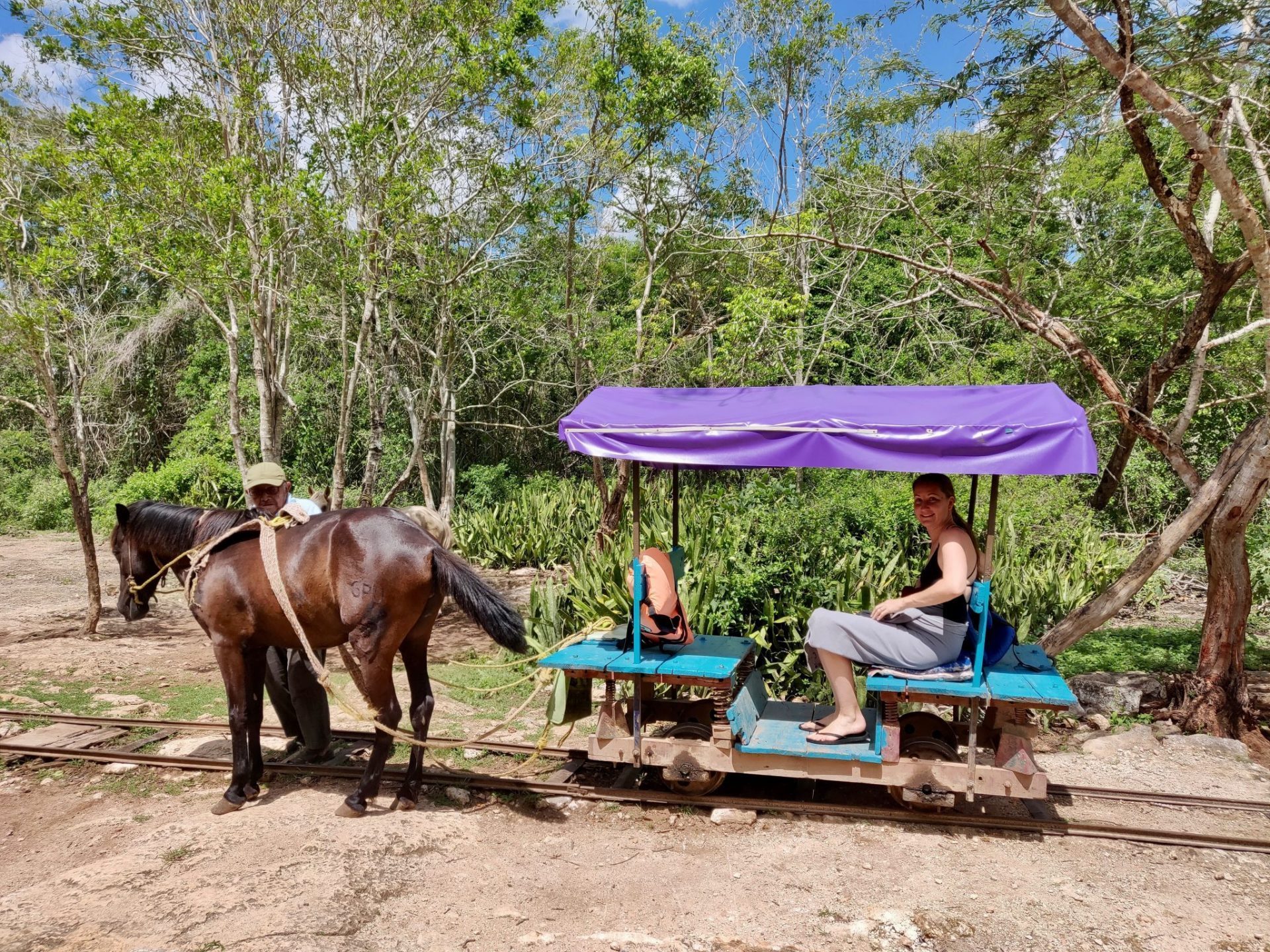
The cenotes are reached over the nine-km-long line. These are a remnant of the henequen (agave rope) industry that briefly made nearby Mérida one of the wealthiest cities in the 19th-century world. Now the ghost rails that once hauled the “green gold” of the Yucatán to the ports of Mexico lug sweaty tourists to the cenotes. Cenotes Chelentún, Chansinic’Ché, and Bolón-Chohol, roughly translated as “lying stone,” “ant tree,” and “bat hole,” are all known as “cántaro” style cenotes. The word describes cavern-like cenotes with an entrance narrower than the width of the water below.
Cenote Chelentún is the smallest and shallowest of the three.$100-pesos less
Chansinic’Ché, however, is almost as impressive as Bolón-Chohol, and its waters are comparably as deep and blue. Hundreds of bats wheel around the cavern.
The most impressive of the three is the massive Bolón-Chohol, a naturally sculpted dome cathedral of water, rock, and vine. A 50-foot vertical ladder descends into apparent blackness. The crystal blue waters, illuminated by a small hole in the ceiling, stretch out like a glass floor. Thirsty tree roots dip down from the dome-like ceiling for a drink; they mingle with tooth-like stalactites. It’s hard not to join the Mayans in imagining this as a dwelling place of the divine.

Bring a mask and snorkel to see all the rock formations lit in the crystal-clear water. Fish are swimming around. There isn’t much to see in the black abyss of the second Cuzama cenote, there was lots lit up in the other two. Masks were not available to rent.

Loltun Caves. The largest caves in Yucatan, human presence dates to 9000 BC. With huge caverns, Mayan carvings and 2 large rooms filled with trees, the caves were a good stop. My drive here started at the Mayapan Mayan ruins, I drove through two towns with no signs (Oxkutzcab had wonderful murals above its market), several one-lane roads and finally the caves,
KOOTENAY MOUNTAINEERING CLUB HIKING CAMPS
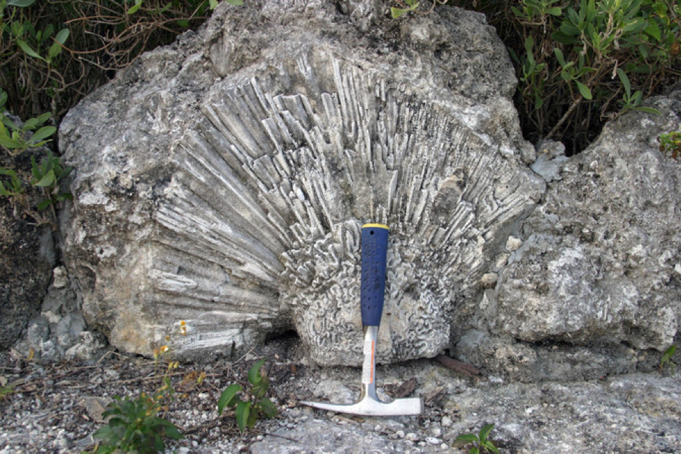
Limestone Lakes, Height of the Rockies Provincial Park. The Kootenay Mountaineering Club had hiking camps here in 1987 and 2009. The outstanding features of the area were Island Lake, a large ultra-marine blue lake flanked by 10,000-foot peaks, stratified cliff faces, and huge fossil beds. It was easy to recognize shells and corals, especially brain corals.
 The 2009 camp was just west of Height of the Rockies Provincial Park. Amazing fossil beds and karst features were the highlight. We hiked on long game trails, the legacy of many mountain sheep.
Karst has sharp edges that make for interesting walking, Climbing is a challenge with the sharp edges to the rock.

Mt Llewellyn, Northern Selkirks. The KMC had a hiking camp here in 2005. The area was 25 km east of Revelstoke, BC. The rock here was limestone creating “disappearing” creeks. One creek came mysteriously out of the side of a mountain. Another creek disappeared underground and reappeared several hundred metres downstream. Mt Kenneth and Llewellyn were technical climbs and not climbed.
GUNING MULU NATIONAL PARK, Sarawak Malaysia May 28 – June 6, 2017
Gunung Mulu National Park is Unesco World Heritage listed. 53,000 hectares, it lies in eastern Sarawak just south of the Brunei border. It is known for its karst formations with pinnacles and magnificent caves. Its altitude varies from 27m at the park headquarters on the floodplains to 2,377m at Mulu summit with topography from flat but deeply cut floodplains to the steep mountain slopes and vertical cliffs of the limestone gorges.
Tropical rainforest (jungle) exists only under 22.5 degrees – it requires high daily temperatures and at least 200mm of rainfall per month. Mulu lies at 4 degrees north.

Biodiversity. The park has amazing biodiversity with 2,000 species of flowering plants, ferns, mosses, fungi, 115 mammals (including 54 species of bats), 305 birds, 197 reptiles and amphibians, 48 fish, and more than 20,000 types of insects and spiders. Many cave-living species are unique.
Most visitors to tropical rainforests expect to see huge numbers of birds, mammals and reptiles scurrying about on the forest floor and swinging through the trees – but that is not what they are like. Despite high biodiversity, there is low species abundance. The animals are all there but are generally very shy of us predatory humans and most of us are not very clever at spotting them. We smoke, wear insect repellent, antiperspirants, and perfumes and make noise. Animals know we are coming long before we are close enough to see them.
Mulu is best known for its caves, the largest caves in the world. The caves were first discovered in 1856 but forgotten until 1961. It wasn’t until 1978 that they were actively explored.
Why are Mulu’s caves so big? The upper limestone layer here is 1500m thick and extremely fine-grained and thus very hard. The limestone under it is thin and much more fragile. With movement of the earth’s crust, the area was tilted and folded 30 degrees producing cracks and fractures, allowing easy water movement through the hard limestone. With lots of rain, cave formation occurs rapidly in geologic time. The cave passages at Mulu are generally long, straight, and wide and tend to be circular in cross-section with little roof collapse. They show 1.5 million years of geologic history. The giant doline of the Garden of Eden is one of the world’s finest examples of the collapse process. Cave fauna has evolved because of the transfer of food energy from the forest to caves by bats and swiftlets. Millions of bats and swiftlets entering and leaving the caves is a spectacle.
The geologic highlight of the park is the Pinnacles, a fantastic collection of razor-sharp limestone formations that rise to 50m. It was entirely booked out when we were to be in Sarawak. This is a 3-day/2-night trip that entails a longboat trip and then an easy 9km walk to a camp. From camp 5, the trail to the ridge overlooking the Pinnacles is 2.4 km and a 1200m vertical climb. The last section is vertical with several ladders and ropes to climb. If the guide thinks you can’t reach the top in time before being able to descend by dark, it is necessary to return to camp. The trip back down is often much harder. You have to supply your food, water and sleeping bag.

Instead of the Pinnacles which required 3 full days, we booked many cave tours.
‘Show Caves.
1. Deer and Lang Caves. Deer is the largest cave passage in the world. This tour is always at the end of the day to see the millions of bats exiting the cave at dusk
2. Clearwater Cave and Cave of the Winds
3. The Fast Lane (includes a 20-minute longboat trip, climbs up to the stalactites at the top of the cave).
Adventure caves: 1. Lagangs Cave (family oriented) 2. Race Cave 3. Clearwater Revival 4. Clearwater Connection (advanced cave, takes 6-8 hours; begins in Cave of the Winds and continues for 5kms of Clearwater Cave, climbs over boulders using fixed ropes and a 1.5km river section that requires swimming) 5. Sarawak Chamber (2 days/1 night, 3h trek, the world’s largest enclosed space – 600m long, 415m wide and 100m high, must be able to swim; one of our guides said it was not a great cave to visit as you can only see the roof and floor, but nothing else as the distances are so big) 6. Kenayaland Cave and Fruit Bat Cave (4-5h) and 7. Stonehorse Cave (2-3h).
Guided walks: 1. Canopy Skywalk (see below) 2. Night Walk (see below) 3. Garden of Eden (see below) 4. Pinnacles and 5. Mulu Summit (24kms, 2400m elevation gain, 4 days/3 nights, guide required).
Unguided walks: 1. Botanical Heritage Trail (1.5km, signs explaining the plants) 2. Kenyalang Loop 3. Paku Valley (8kms that takes 5-6h) 4. Paku Waterfall 5. Long Langsat Walk and 6. Kuala Litut + Camp 5 (90-minute longboat ride)
Day 1 & 2. It was a long day of travel – a 3h train from Shenfang (the closest high-speed rail station to Hongqiao) to Hangzhou, a 4h flight in the middle of the night to Kuala Lumpur, an hour flight to Miri, Sarawak and then a 30m flight to Mulu National Park.
Downtown Miri doesn’t have much to see or eat. From the airport, shuttle or walk to the NP headquarters 1 km.
Night walk. A loop through the forest on the boardwalk. See insects, spiders: many thorny stick insects (some are huge and we saw a copulating couple where the female was 10x the size of the male), millipedes, tarantulas, scorpions, normal stick insects and heard the constant magical sound of katydids. A rufus kingfisher, river frogs, tiny tree-hole frogs many geckos and giant snails that hung out on tree trunks.
Paku Waterfall. 8km walk in the woods. We saw no critters. 2 hours.
Racer Cave. Bats and guano, swarms of flies (bats do not eat the insects inside their caves) and a small shelf that always has racer snakes, for whom the cave is named. They are large, bright lime green and can snatch bats and swiftlets out of the air. The cave has a few nice formations but nothing spectacular. Everyone got pretty dirty.
Clearwater Revival. This “intermediate” cave includes both show caves: Clearwater and Wind Cave.
Wind Cave: A cooling wind but no longer has an active river. Evidence of the river is all around you. The passage leads to the King’s Chamber’, good stalagmites and columns.
Clearwater Cave: A crystal clear river flows through this cave for over 200 km, making it the 10th longest cave in the world. We waded through all varieties of cave terrain: narrow passages, areas with low roofs (if high water, this cave cannot be done because of these areas), lots of mud and some larger caverns. We finally reached the actual cave and walked past the walkway along the rocky bank for several hundred metres including an area of rockfall. It was then swimming time – we swam back down to the walkway with the current. Anna can’t swim so we used a dry bag inside a small backpack to add flotation and gave a brief lesson on breaststroke. She floated on her back and did fine. Back at the walkway, we climbed the stairs to visit the Lady Cave (a front-lit stalagmite casts a shadow vaguely like a woman’s face).
There was an example of an odd speleoform, phytokarst needles – these form where a light source and cyanobacteria dissolve the limestone forming deep pits and long needles that point in the direction of the light source.
The walkway dead ended at a huge hole. We exited the system via a high open entrance (the normal way to enter and exit Clearwater Cave) and descended a long flight of steps to the picnic area. Full of people when we entered, it was now empty.


Day3. We took it easy and read in the morning.
Canopy Walk. At 480m, this is the longest canopy walk in the world. It is 30-50m off the ground and follows a loop crossing the river twice. There wasn’t much to see until the end where a pit viper (quite poisonous) sits next to the canopy. All the huge trees that form the anchors for the canopy walkways are labelled with names and information. I wouldn’t bother if I had other things to do.
Day 4
Garden of Eden. This includes Lang and Deer Caves and a walk through the Garden of Eden to a waterfall and back, followed by viewing the bat exodus.
Deer Cave. This is the largest cave passage in the world – 2 km long and 174m high. It has a colony of 2-3 million bats. There are 12 species of bats, most are wrinkle-lipped bats. Each bat weighs about 15 grams and eats approximately 2/3s of its body weight in insects every night – that equals about 20 tonnes of insects per night for the whole colony. Bats also play an active role in pollinating plants – fruits favoured by bats hang upside down, and have flowers that open at night and are white.
The cave also has swiftlets, the birds whose saliva makes their nests and is valued as bird’s nest soup. They also use echolocation to navigate the dark caves but have an audible click whereas the sound bats use is outside the range of the human ear. As swiftlets feed during the day, the residents of the cave provide 24-hour, around-the-clock insect control. Deer Cave is always visited late in the day to see the bat exodus.

Tiny figures show the scale of the Deer cave looking back to the mouth of the Deer cave, Mulu National Park, Sarawak, island of Borneo, Malaysia
It is a truly huge cave up to 125m high. We walked on gangplank and scrambled over a boulder field to where the cave ends and you enter the Garden of Eden. Cross the Eden River to a lovely cascading waterfall and pool where we swam. It started to rain hard and Deer Cave can become impassable.

Deer Cave has a tremendous amount of guano – guano covers everything and there are even guano dunes. The shower is a waterfall in the centre of the roof of Deer. A viewpoint on the boardwalk had a laser used to determine the dimensions of the cave.
Lang Cave. Above Lang is a lake so there is a constant drip from above. Lang is easily the most spectacular of caves in Mulu because of its formations – interesting stalagmites and ‘tites’, large curtains, and some wavey, big areas of flow with tendrils that look like a jellyfish or coral. The cave is only 280m long.
The Bat Exodus. Between 5 and 6 pm, 3 million bats leave the cave for a night of feeding. The bats exited at 6 and it took over a half hour for them to leave. There was a huge crowd there, possibly 150 people.

Hornbills. Thes prehistoeric-looking birds are an important ecological indicator of the health of the forest. They are large, black-and-white birds with disproportionately huge bills, often bent downwards, topped with an ornamental casque, a generally hollow structure attached to the upper mandible (function unknown but probably attracts a mate). Ten of the world’s 46 species of hornbill are found in Malaysia, many in small, isolated populations. Good places to see them are Gunung Mulu NP Sabah’s Danum Valley and Gunung Kinabalu NP.
TSINGY de BEMARAHA NATIONAL PARK, Madagascar
Morning departure from Morondova for Bekopaka.
Drive through the Avenue de Baobabs, 7 km to the Baobab Amoureux and then a large “forest” of hundreds of smaller baobabs spread over a large area.
The ferry over the Tsirbihina River was flat-decked carrying four vehicles and powered by two ancient 20-horsepower engines. A belt drove the propellers and the two drivers poured gallons of water into the reservoir to cool the engines. The ferry went upstream about 3 km to the takeout.
We stopped at the Mad Zebu (Malagasy fine dining in Belo Tsiribihina) for lunch for an hour. Ariel had zebu and I had pork, both delicious and costing 40,000.
An armed 4WD convoy was needed for last four hours after the Mad Zebu. Just before Bekopaka, we crossed another river on a ferry.
The 11.5-hour drive was on dirt roads, some smooth, other washboards and a lot of washed-out ruts. In every village, there were tons of little kids. Just before Bekopaka, we crossed the Tsibirinha River on another ferry.
We had dinner at 7 and went to bed early.
ON Orchidee Hotel, Bekopaka.
Tsingy de Bemaraha National Park. Tsingy is the Malagasy word for “walking on tiptoes”. The site is famously home to a jagged, pointed limestone formation, hence the reason to “walk on tiptoes”. There is a lot of endemic fauna and flora.
It was a 50-minute drive on a bad water-eroded road. In the forest, we saw some “brown” lemurs. Using climbing harnesses with two locking carabiners, move through a constructed loop trail with ladders, limestone rocks “nailed” into the stone as steps, boardwalks and a nice cable bridge above an abyss. There were many cables bolted into the rocks to attach our carabiners, but I thought it all unnecessary and cumbersome as we were always transferring carabiners to the next cable. There are two great viewpoints. We had lunch of a bunch of bananas in the “cathedral”, an area at the bottom of the tsingy in the shade. We also saw a rat, a gorgeous mongoose with a long brown/black striped tail and three lovely Deckens sifaka as they leapt between branches in the canopy of the trees. The entire tour took about four hours.
The article in National Geographic showed the Deckens sifaka climbing on the needle-sharp tsingy. Our guide had never seen the lemur on the tsingy. They must have baited them with food to get them there.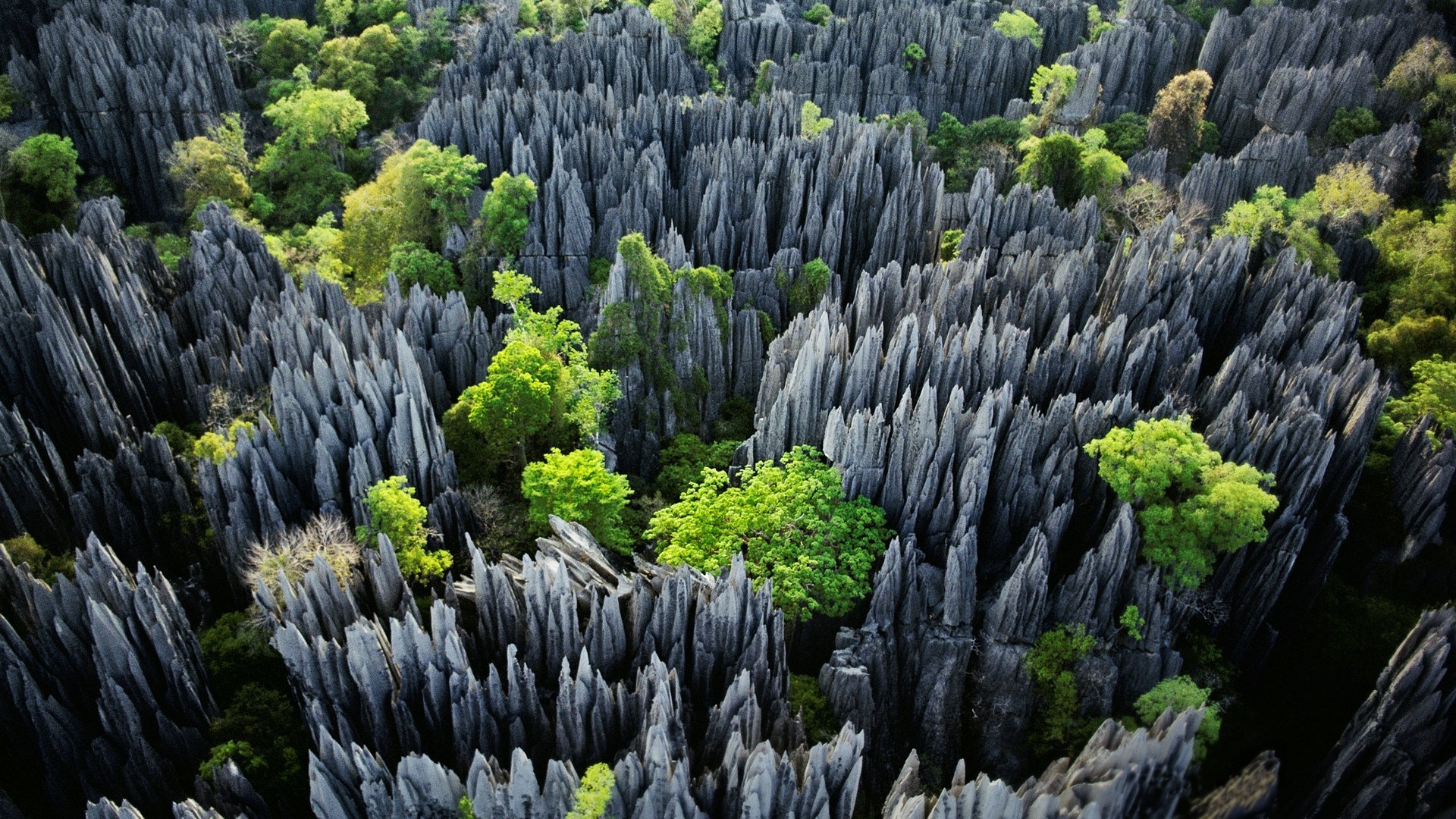
Real “Baobab Amoureux” another two big trees twisted around each other, better than the one most commonly seen. There were hundreds of nice wood carvings of baobabs for sale here. I should have bought one but didn’t.  Avenue of the Baobabs. Everyone congregates on the east side of the avenue behind a pond full of lilies for sunset for silhouettes.
