
Patagonia is a geographical region at the southern end of South America, governed by Argentina and Chile. It includes the southern section of the Andes Mountains with lakes, fjords, temperate rainforests, glaciers in the west and deserts, tablelands, and steppes to the east. The Pacific Ocean is on the west, the Atlantic Ocean to the east, and many bodies of water connect them, such as the Strait of Magellan, the Beagle Channel, and the Drake Passage to the south.
The Colorado and Barrancas rivers, which run from the Andes to the Atlantic, are commonly considered the northern limit of Argentine Patagonia. The archipelago of Tierra del Fuego is sometimes included as part of Patagonia. Most geographers and historians locate the northern limit of Chilean Patagonia at Huincul Fault, in the Araucanía Region.
Patagonia is divided between Western Patagonia (Chile) and Eastern Patagonia (Argentina). Several territories are under dispute.
Climate
The high rainfall against the western Andes (Wet Andes) and the low sea-surface temperatures offshore give rise to cold and humid air masses, contributing to the ice fields and glaciers, the largest ice fields in the Southern Hemisphere outside of Antarctica.
Patagonia’s climate is mostly cool and dry year-round. The east coast is warmer than the west, which is washed by a cold current.
The prevailing winds are westerly, and the westward slope has much heavier precipitation than the eastern in a rainshadow effect – the western islands close to Torres del Paine receive annual precipitation of 4,000 to 7,000 mm, the eastern hills less than 800 mm and the plains may be as low as 200 mm.
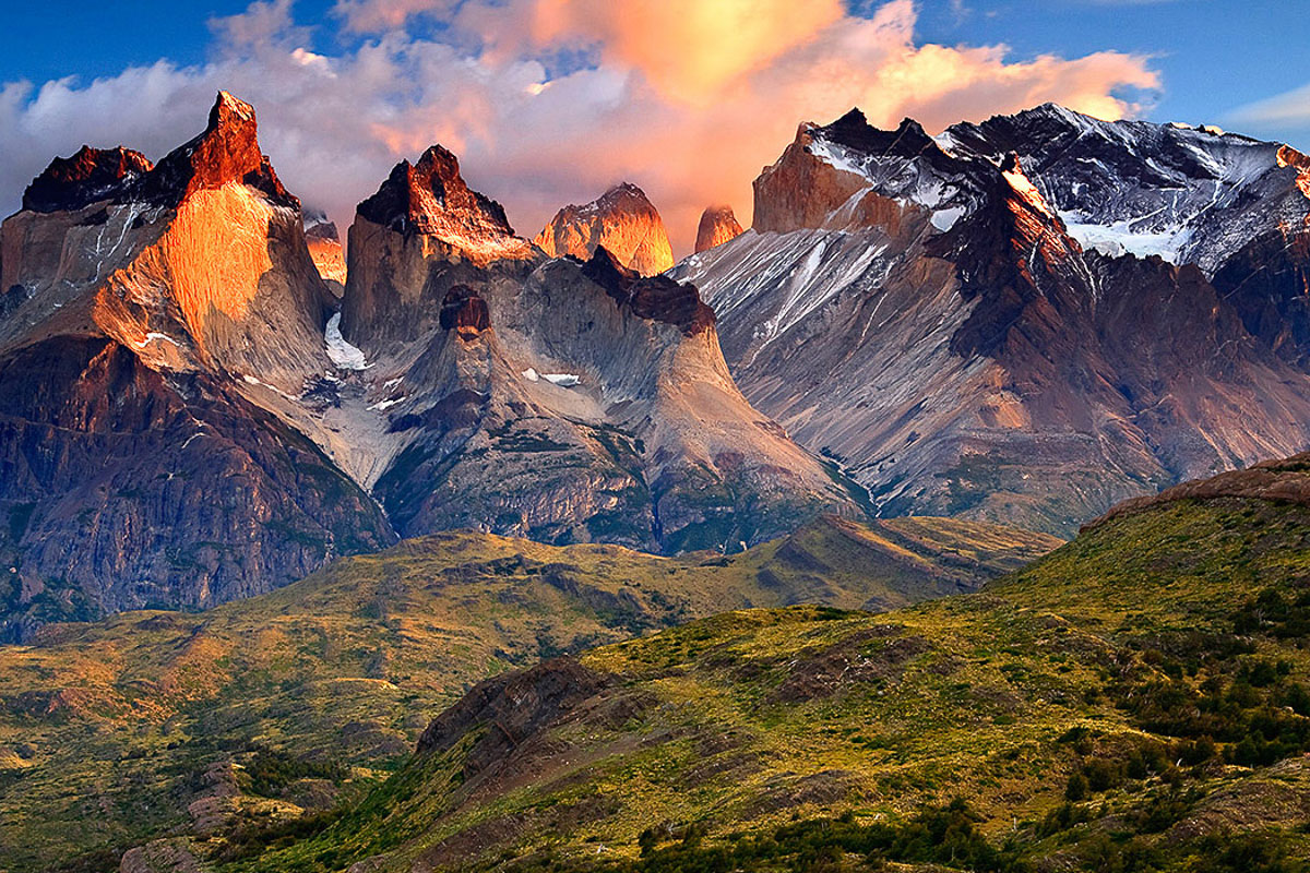
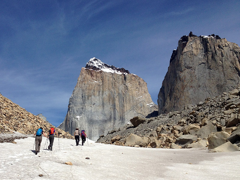
TORRES DEL PAINE
Torres de Paine is a national park encompassing mountains, glaciers, lakes, and rivers in southern Chilean Patagonia. The Cordillera del Paine is the centrepiece of the park located 112 km north of Puerto Natales and 312 km north of Punta Arenas. The park borders Bernardo O’Higgins National Park to the west and the Los Glaciares National Park to the north in Argentine territory.
Paine means “blue” in the native Tehuelche language and is pronounced PIE-neh. It was established as a National Park in 1959.
It is one of the largest and most visited parks in Chile. The park averages around 252,000 visitors a year, of which 54% are foreign tourists,
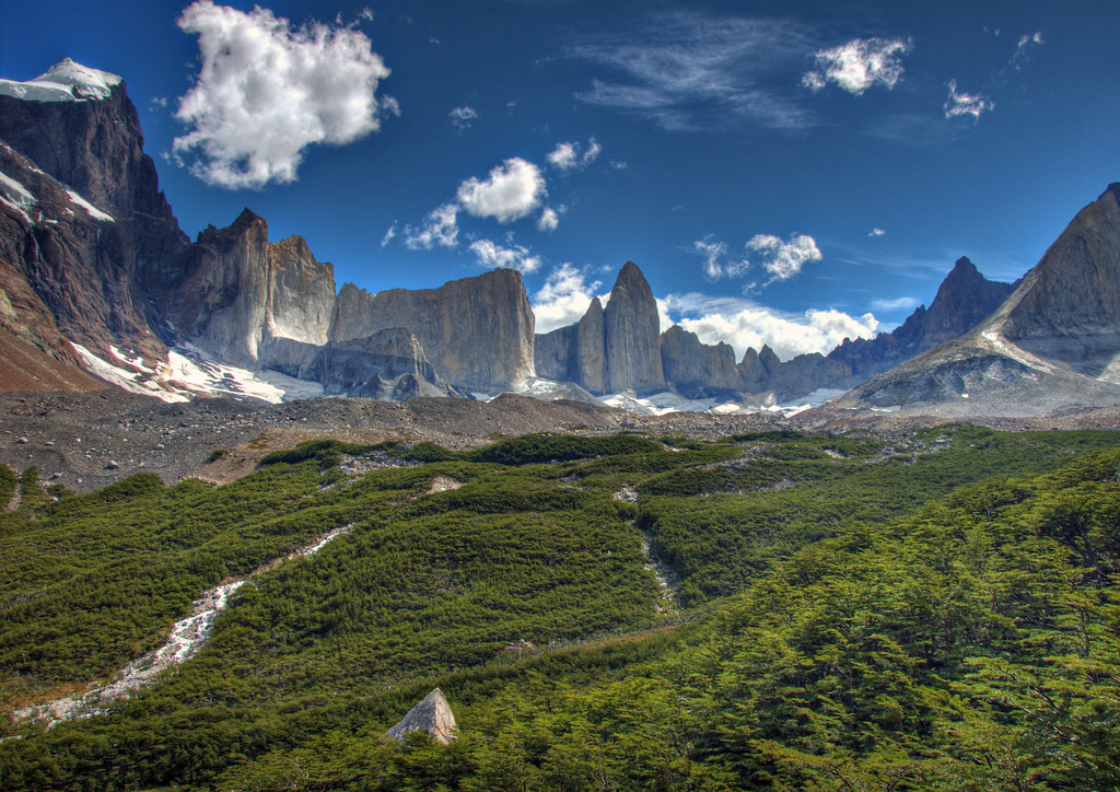
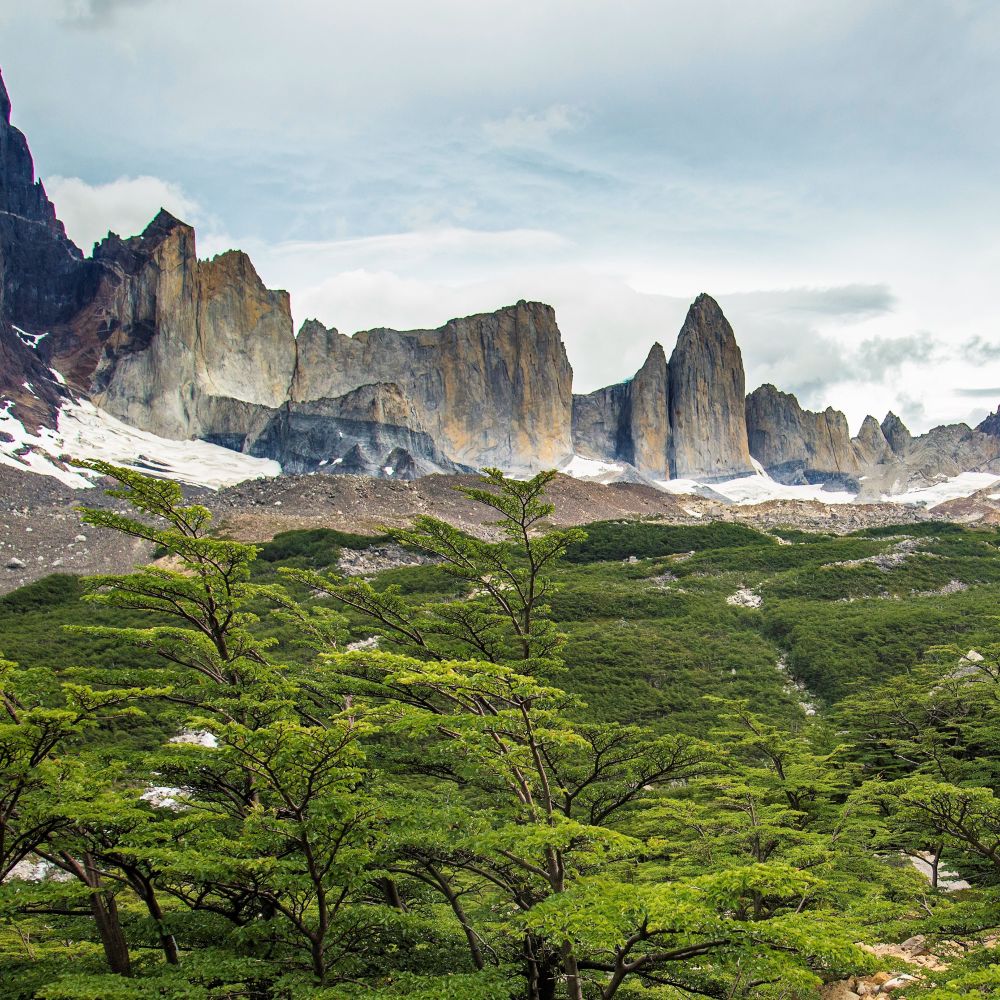
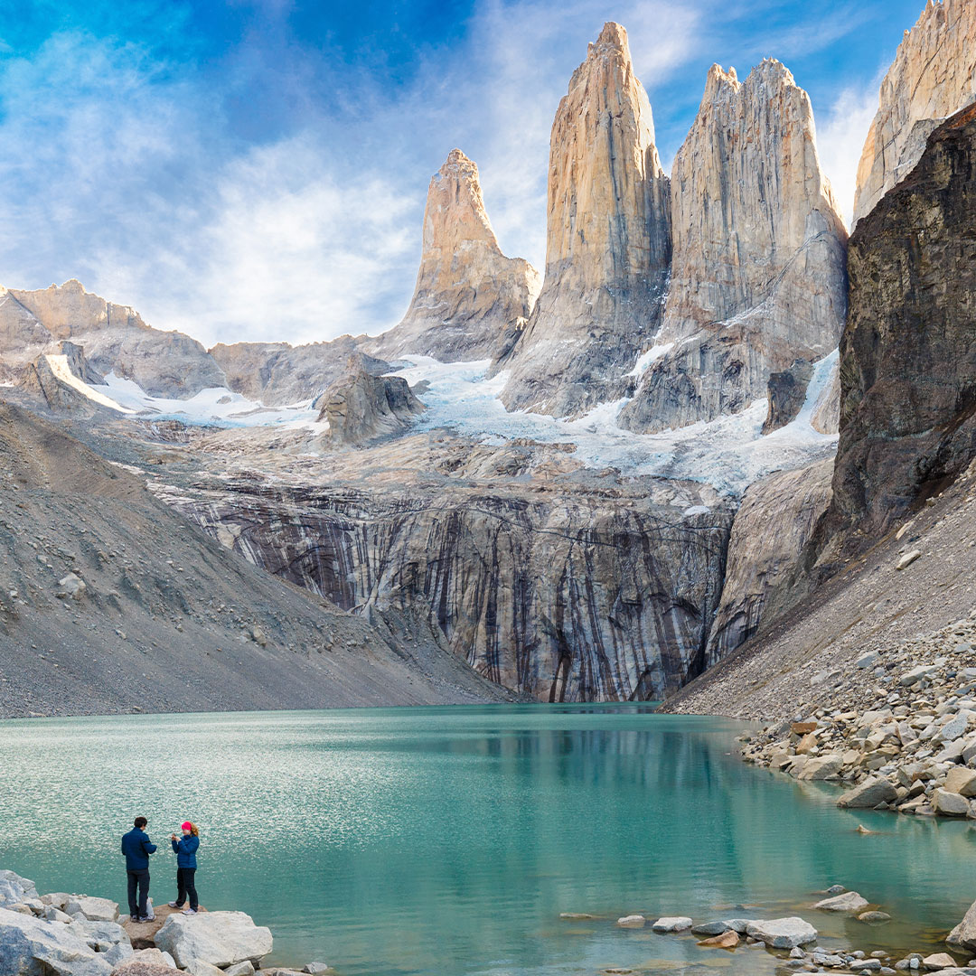
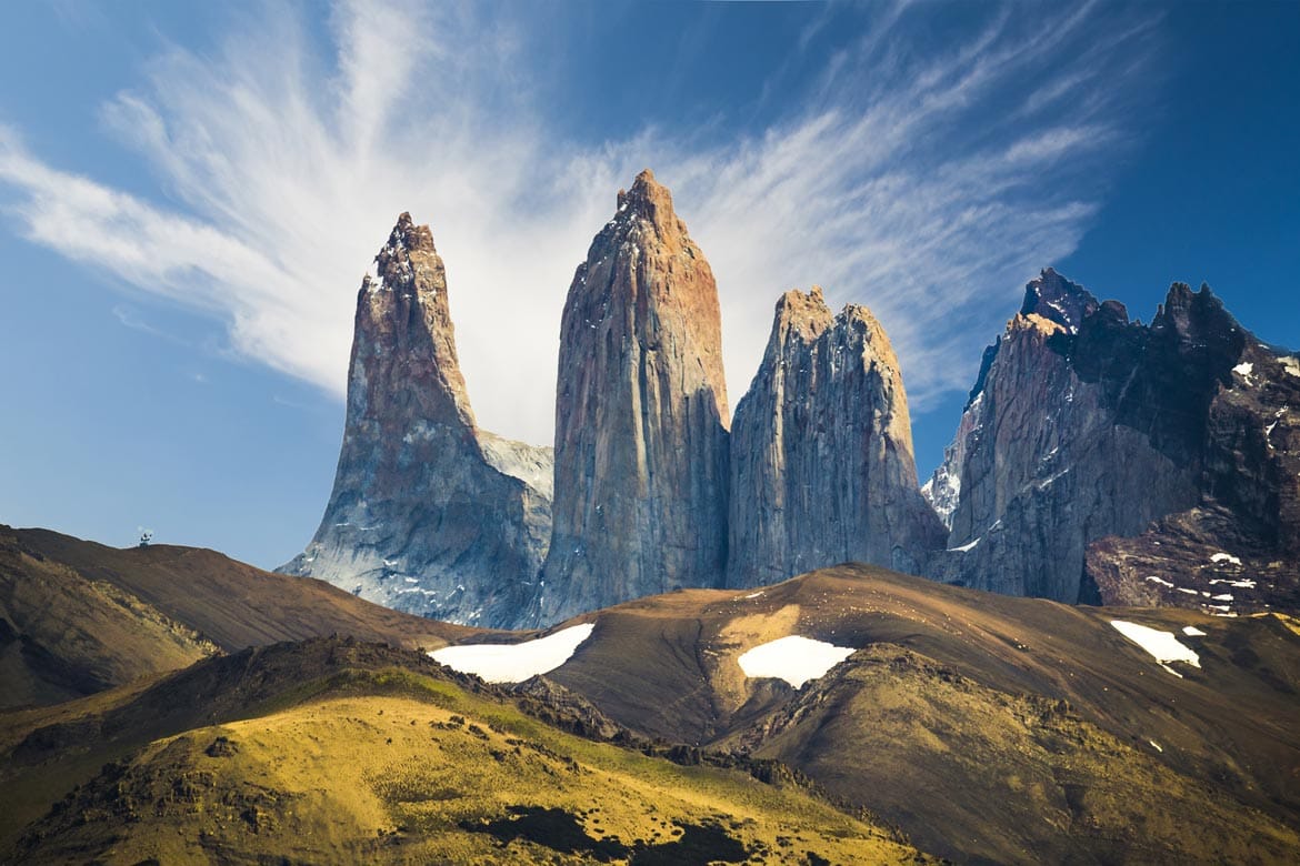
The landscape of the park is dominated by the Paine massif, which is an eastern spur of the Andes located on the east side of the Grey Glacier, Small valleys separate the granite spires and mountains of the massif. These are: Valle del Francés (French Valley), Valle Bader, Valle Ascencio, and Valle del Silencio (Silence Valley).
The W trek ascends to Lago Grey, the French Valley and the towers.

![Sunrise at Torres del Paine National Park [OC] [1920x1280] Reflection ...](https://i.pinimg.com/originals/fb/1f/25/fb1f256cf41eb74de145da7d613a4733.jpg)
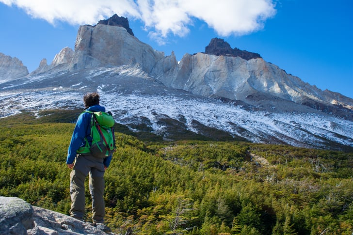
French Valley. The head of French Valley is a cirque formed by tall cliffs. The colossal walls of Cerro Cota 2000 and Cerro Catedral punctuate the western region of the Valley. Cerro Cota 2000 is named for its elevation; its highest contour line is about 2,000 m (6,562 ft). Cerro Catedral’s east face resembles a cathedral’s facade. To the north stands the granite arête called Aleta de Tiburón (English: Shark’s Fin). To the east, from north to south, lie the peaks Fortaleza (Fortress), La Espada (The Sword), La Hoja (The Blade), La Máscara (The Mummer), Cuerno Norte (North Horn), and Cuerno Principal (Main Horn),
Valley of Silence The gigantic granite walls of Cerro Fortaleza and Cerro Escudo (Shield Mountain) stand face to face with the western faces of the Torres del Paine. Ascencio Valley is the normal route to reach the Torres del Paine lookout located at the bank of a milky green tarn. The highest mountain of the group is Paine Grande, whose height is 2,884 m (9,462 ft).
The Torres del Paine (“Towers of Paine”) are the distinctive three granite peaks of the Paine mountain range. From left to right they are known as Torre d’Agostini, Torre Central and Torre Monzino. They extend up to 2,500 metres (8,200 ft) above sea level and are joined by the Cuernos del Paine (“Horns of Paine”).
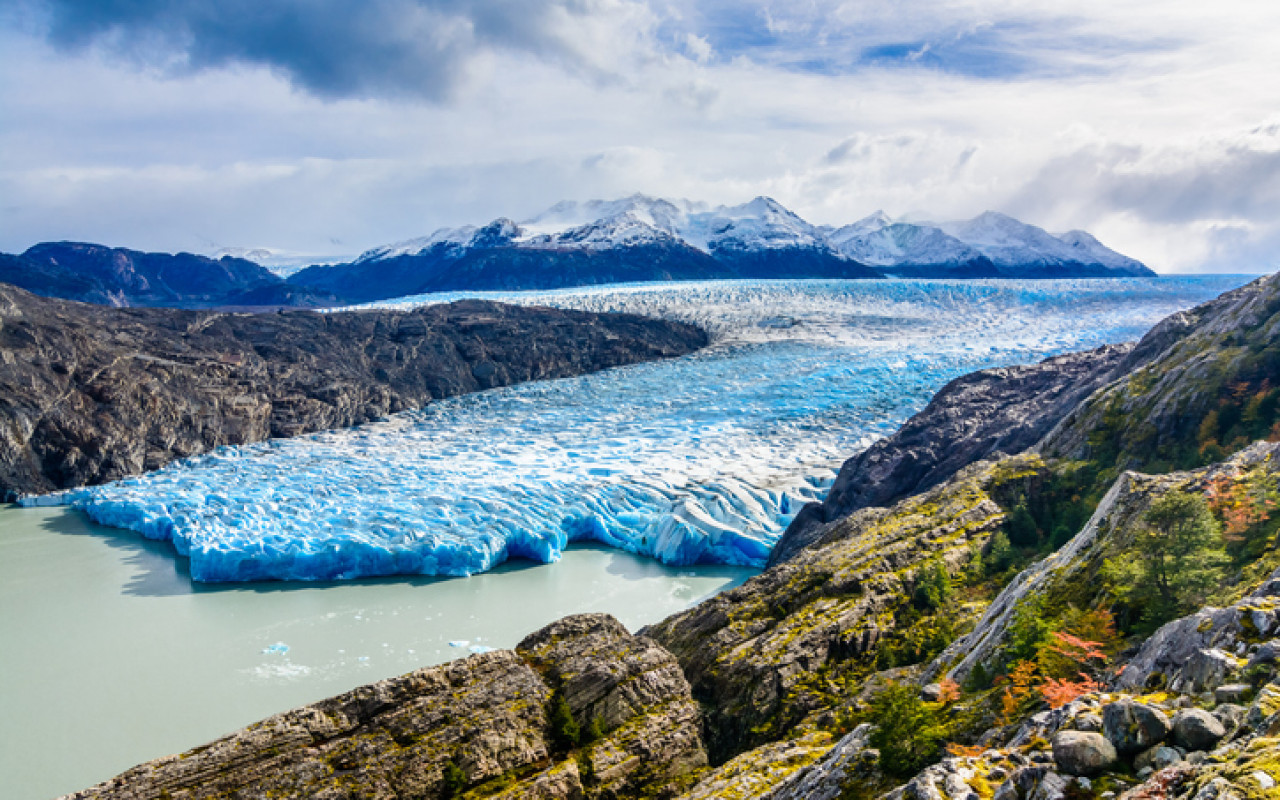
The Grey Glacier is the largest and is divided into two arms because of a peninsula of ice, commonly called an island or Nunatak, that becomes apparent a little more each year. The eastern arm measures about 1.2 km while the western has a width of around 3.6 km.
Fires. In 1985, a tourist started a fire that burned about 150 km2 (58 sq mi) of the park. The blaze affected the areas east and south around Lake Pehoé. In February 2005, an accidental fire started by a Czech backpacker, which lasted for about ten days, destroyed 155 km2 (60 sq mi) of the park. In late December 2011 through January 2012, an Israeli backpacker was charged with having started a fire after being caught by a park ranger when lighting up some paper roll in a forbidden area. The fire burned about 176 km2 (68 sq mi) of the reserve, destroying about 36 km2 of the native forest.
Climate. The park lies in the “temperate climate of cold rain without a dry season.” The meteorological conditions of the park are variable due to the complex orography. The park is famous for its strong winds. The windiest months are November – January, which coincides with the peak tourism season.
Cool summers, with temperatures lower than 16 °C during the warmest month (January). Winter is relatively cold, with an average high temperature in July of 5 °C (41 °F), and an average low of −3 °C (27 °F).
The rainiest months are March and April, with a monthly average rainfall of 80 mm. This represents double the July–October (winter) rainfall.
Hydrology. The park possesses a large drainage network, which consists of numerous rivers, streams, lakes, ponds, and cascades that come from the Southern Patagonia Ice Field and flow towards the southeast until the Última Esperanza Sound that bathes the coasts of the city of Puerto Natales.
The Southern Patagonian Ice Field takes up the entire western side of the park. The Southern Patagonian Ice Field feeds four main glaciers from north to south the glaciers: Dickson, Grey, Zapata, and Tyndall. This last glacier is rapidly receding.
Geology.
Glacial erosion is mainly responsible for sculpturing the massif in the last tens of thousands of years. A good example of the latter is the Cuernos del Paine, whose central bands of exposed granite contrast strongly with the dark aspect of their tops, remnants of a heavily eroded sedimentary stratum. In the case of Las Torres, what once was their overlying sedimentary rock layer has been completely eroded, leaving behind the more resistant granite.
Fauna. Guanacos are one of the most common mammals found in the park. Other mammals include foxes and pumas.[The national park has over 252,000 visitors per year.
Sleep. Many refugios provide shelter and basic services. Hikers can opt for a day trip to see the towers, French Valley or Glacier Grey or a multi-day trek. Multi-day treks include the popular “W” route, which takes about three to five days, and the full circuit or “O” route, which typically takes 7 to 9 days. The Refugio locations also have campsites and tents for hire. Cooking with a camping stove is not permitted except in Refugio locations. Camping is only allowed at specified campsites and wood fires are prohibited throughout the park. Since October 2016, it has been mandatory to book campsites or refugios before entering the park. For less adventurous visitors, there are several hotels located in and around the park.
Time to Visit. A good time to visit Torres del Paine is between October and April because there is less rain. But, during high season the entrance fee is more expensive than between May and September. Visiting the park is recommended between September and April, during the southern spring, summer, and early autumn. During summer, daylight hours are long given the southern latitude. Outside of this time frame, the weather becomes extreme for most of the public. During the southern winter, daylight dwindles to only 8 hours a day.
Get There. The park can be reached by Chile Route 9, which is paved and connects Punta Arenas and Puerto Natales and continues as an asphalt road for 100 km and then becomes a gravel road. In the winter using tire chains is recommended. The park can also be reached through maritime and aerial routes. Buses leave from Puerto Natales.
PERITO MORENO GLACIER
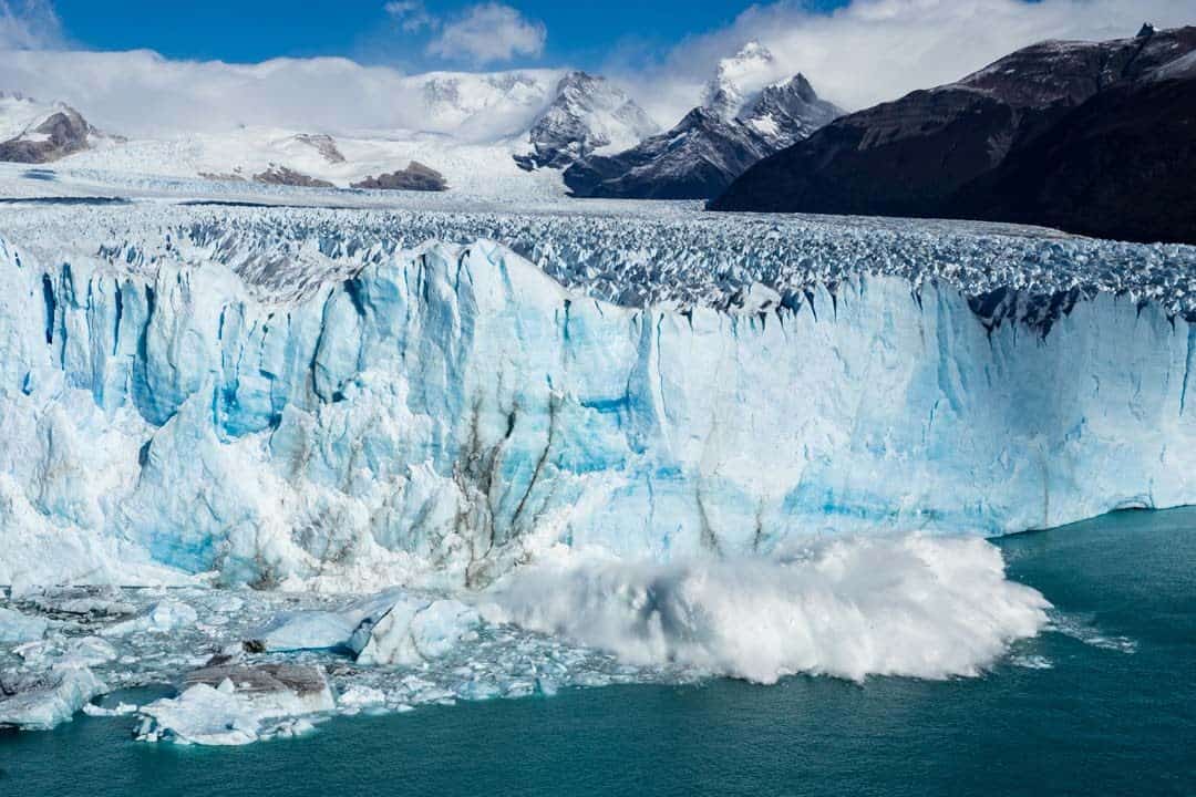
Perito Moreno is a glacier in Los Glaciares National Park. It is one of the most important tourist attractions in the Argentine Patagonia. The 250 km2 (97 sq mi) ice formation, 30 km (19 mi) in length, is one of 48 glaciers fed by the Southern Patagonian Ice Field located in the Andes system shared with Chile which has a small part of the origins of the glacier. This ice field is the world’s third-largest reserve of fresh water.
It is located 78 kilometres from El Calafate and was named after the explorer Francisco Moreno, a pioneer who studied the region in the 19th century and played a major role in defending the territory of Argentina in the conflict surrounding the international border dispute with Chile.
Since 2020 the glacier has been retreating on its northern front, possibly due to climate change. It was previously one of the few unusual glaciers that maintained a state of equilibrium during the late 20th and early 21st centuries because it was accumulating mass at a rate similar to its loss.
The terminus of the Perito Moreno Glacier is 5 km (3.1 mi) wide, with an average height of 74 m (240 ft) above the surface of the water of Argentino Lake, in Argentina. It has a total ice depth of 170 metres (558 ft).
Ruptures of the glacier. Pressure from the weight of the ice slowly pushes the glacier over the inner fjord of Lake Argentino reaching the coast of Península de Magallanes and bisecting the lake at an area called the Brazo Rico (Rico Arm) on one side and the Canal de los Témpanos (Iceberg Channel) on the other. With no outlet, the water level on the Brazo Rico side of the lake can rise by as much as 30 meters above the level of the main body of Argentino Lake. Intermittently, the pressure produced by the height of the dammed water breaks through the ice barrier causing a spectacular rupture, sending a massive outpouring of water from the Brazo Rico section to the main body of Lake Argentino and the Santa Cruz River. As the water exits Brazo Rico, the scored shoreline is exposed, showing evidence of the height of the water build-up. This dam–ice-bridge–rupture cycle recurs naturally between once a year to less than once every decade.
The glacier advances between June and December and recedes between December and April. The formation of an ice barrier is a complex process, since there is a feedback mechanism between the glacier and the lake, which affects the oscillations of the position of the glacial front in a fairly stable way. The discharge of the water can be sudden, progressive or minor burst. In a sudden type event, the maximum discharge can reach 8000 m³ per second, while a smaller event only evacuates 123 m³. The ruptures occurred in the years, 1917, 1935, 1940, 1942, 1947, 1952, 1953, 1956, 1960, 1963, 1966, 1970, 1972, 1975, 1977, 1980, 1984, 1988, 2004, 2006, 2008, 2012, 2013 (two events, one in January and one in December), 2016, 2018 and 2019.
Tourism. Due to its size and accessibility, Perito Moreno is one of the major tourist attractions and the rupture of this glacier is considered one of the most impressive natural spectacles in the world. El Calafate is a funky, small town on Lago Argentino, the largest freshwater lake in the country. It has an international airport and many tour companies run daily tours. A large visitor centre at the site features a walking circuit with a view of the southern flank and the east-facing edge of the glacier. Trekking tours on the ice have gained popularity. Boats are also available to get up close to the calving ice.
The bus to the glacier costs 570 ARS (US$32.50) and takes 90 minutes. The entrance fee was 450 ARS (US$29.50), cash only.
![]()
![]()
FITZROY
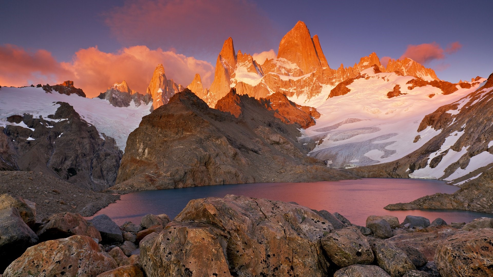
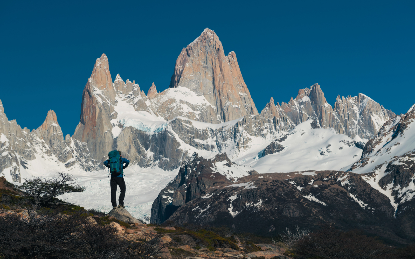
Monte Fitz Roy is a mountain in Patagonia, on the border between Argentina and Chile. It is in the Southern Patagonian Ice Field, near El Chaltén village and Viedma Lake. It was first climbed in 1952 by French alpinists Lionel Terray and Guido Magnone.
Argentine explorer Francisco Moreno saw the mountain on 2 March 1877; he named it Fitz Roy in honour of Robert FitzRoy who, as captain of HMS Beagle, had travelled up the Santa Cruz River in 1834 and charted large parts of the Patagonian coast.
Notable ascents
• 1952, Lionel Terray and Guido Magnone via Southeast Ridge (Franco-Argentine Ridge) (first ascent – 2 February 1952)
• 1968, Southwest Ridge aka The Californian Route (third ascent). Ascent by the “Fun Hogs”: Yvon Chouinard (who went on to found outdoor clothing and equipment company Patagonia and climbing equipment company Black Diamond Equipment), Dick Dorworth, Chris Jones, Lito Tejada-Flores (filmmaker, whose 16mm Bolex camera footage of the ascent was used for the film of the expedition entitled Mountain of Storms) and Douglas Tompkins (who, in 1964, had co-founded outdoor equipment and clothing company The North Face).
2002, Dean Potter, first free solo, via Supercanaleta
• 2014, February 12-16. Tommy Caldwell and Alex Honnold completed the first full traverse climbing across the ridge line of Fitz Roy and its satellite peaks. The route is 5 kilometres long and has approximately 4,000 meters of cumulative elevation gain, with technical climbing of up to 5.11d (7a). They were both awarded the Piolet d’Or for their climb.
CERRO TORRE
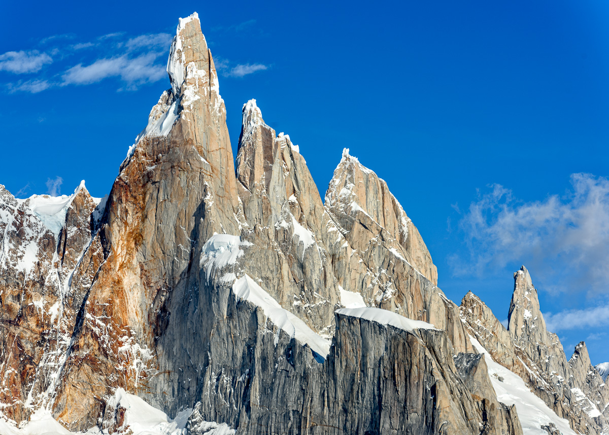
Cerro Torre is a mountain on the Southern Patagonian Ice Field west of Fitz Roy. The peak is the highest of four mountain chains: the other peaks are Torre Egger (2,685 m (8,809 ft)), Punta Herron, and Cerro Standhardt. The top of the mountain often has a mushroom of rime ice, formed by the constant strong winds, increasing the difficulty of reaching the actual summit.
Cesare Maestri claimed in 1959 that he and Toni Egger had reached the summit and that Egger had been swept to his death by an avalanche while they were descending. Maestri declared that Egger had the camera with the pictures of the summit, but this camera was never found. Inconsistencies in Maestri’s account, and the lack of bolts, pitons or fixed ropes on the route, have led most mountaineers to doubt Maestri’s claim. In 2005, Ermanno Salvaterra, Rolando Garibotti and Alessandro Beltrami, after many attempts by world-class alpinists, put up a confirmed route on the face that Maestri claimed to have climbed. They found no evidence of previous climbing on the route described by Maestri and found the route significantly different from Maestri’s description.
Maestri returned to Cerro Torre in 1970 with Ezio Alimonta, Daniele Angeli, Claudio Baldessarri, Carlo Claus and Pietro Vidi, trying a new route on the southeast face. With the aid of a gas-powered compressor drill, Maestri equipped 350 metres (1,150 ft) of rock with bolts and got to the end of the rocky part of the mountain, just below the ice mushroom. Maestri claimed that “the mushroom is not part of the mountain” and did not continue to the summit. The compressor was left, tied to the last bolts, 100 m (330 ft) below the top. Maestri was heavily criticized for the “unfair” methods he used to climb the mountain.
The route Maestri followed is now known as the Compressor route and was climbed to the summit in 1979 by Jim Bridwell and Steve Brewer. Most parties consider the ascent complete only if they summit the often-difficult ice-rime mushroom.
The first undisputed ascent was made in 1974 by the “Ragni di Lecco” climbers Daniele Chiappa, Mario Conti, Casimiro Ferrari, and Pino Negri. The controversies regarding Maestri’s claims are the focus of the 2014 book on Cerro Torre, The Tower, by Kelly Cordes.
Subsequent Ascents In 1977, the first Alpine-style ascent was completed by Dave Carman, John Bragg and Jay Wilson (USA). They took a week to summit Cerro Torre, which had taken the Italian group two months to summit. In 1980, Bill Denz (New Zealand) attempted the first solo of the Compressor Route. Over a five-month period, he made 13 concerted attempts but was driven back by storms on every occasion. On his last attempt, in November 1980, he got to within 60 metres (200 ft) of the summit. In January 2008, Rolando Garibotti and Colin Haley made the first complete traverse of the massif, climbing Aguja Standhardt, Punta Herron, Torre Egger and Cerro Torre together. They rate their route at Grade VI 5.11 A1 WI6 Mushroom Ice 6, with 2,200 m (7,200 ft) total vertical gain. This had been “one of the world’s most iconic, unclimbed lines”, first attempted by Ermanno Salvaterra.
In 2010, Austrian climber David Lama was held responsible for around 30 new bolts and hundreds of meters of fixed rope added to the Compressor Route on the mountain (due to bad weather conditions, much of the gear was left on the mountain and later removed by local climbers). Although the bolts were drilled by Austrian guide Markus Pucher, and not by Lama himself, it was done as part of his trip sponsored by Red Bull, and many climbers regard Lama and Red Bull as responsible. Many of the bolts were drilled next to cracks, which are usually used by climbers for protection on the route. This has caused a large controversy in certain climbers’ circles, as his actions are unethical according to climbing purists. Although Lama was unaware of the sheer number of bolts drilled, he took full responsibility for the actions. In the upcoming years, he publicly regretted what happened.
On 16 January 2012, American Hayden Kennedy and Canadian Jason Kruk made the first “fair-means” (a term used to describe a reasonable use of bolts for safety and aesthetics, “a long-accepted practice in [the Patagonian] mountain range”) ascent of the Southeast Ridge, near the controversial Compressor Route, using only two of Maestri’s original belay anchors on the headwall. After summiting, Kennedy and Kruk removed 125 of the bolt-ladder bolts during their descent. Colin Haley, who watched the ascent from Norwegos, estimated the climb took them thirteen hours from their bivy on the shoulder to the summit. “The speed with which they navigated virgin ground on the upper headwall is certainly testament to Hayden’s great skills on rock”, Haley reported. There has been much discussion concerning removing bolts from the compressor route by Kennedy and Kruk. However, the consensus amongst the climbing community is the agreement for removing the bolts has embraced their actions as having “restored Cerro Torre’s southeast ridge to the realm of genuine adventure”.
In contrast to David Lama’s free ascent (also “fair-means”; January 2012, together with Peter Ortner), Kennedy and Kruk used bolts, although not Maestri’s, during their ascent Lama estimated the difficulties of his free ascent, which followed a new line circumventing the bolt traverse and in the upper headwall, as grade X− (hard 8a but mentally highly demanding; e.g., climbing on loose flakes, long runouts). Lama stated that a free repetition of the original Compressor Route is virtually impossible, in particular as the rock of the last pitches comprise no climbable features.
- 1959 – Cesare Maestri (Italy) and Toni Egger (Austria) – Unsuccessful attempt of North Face. Egger died.
- 1970 – Maestri et al. (Italy), Compressor route to 60 meters below the summit.
- 1973 – Keven Carroll (AUS) and Steven McAndrews (USA) West Face 5th ascent. Died on the descent from rock fall. Earlier seen on the summit ridge.
- 1974 – Daniele Chiappa, Mario Conti, Casimiro Ferrari and Pino Negri (Italy). First undisputed ascent.
- 1977 – Dave Carman, John Bragg and Jay Wilson (USA). First Alpine-style ascent.
- 1979 – Jim Bridwell and Steve Brewer complete the climb of the Compressor Route.
- 1981 – Tom Proctor and Phil Burke (England). Diedre, East Face to North Face and retreat below cornices.
- 1985 July 3–8 First winter ascent by Paolo Caruso, Maurizio Giarolli and Ermanno Salvaterra (Italy).
- 1985 November 26 Compressor route – first solo by Marco Pedrini (Swiss). Filmed by Fulvio Mariani: Cerro Torre Cumbre.
- 2004 Five Years to Paradise (ED: VI 5.10b A2 95 deg, 1000 m) (right center on East Face): Ermanno Salvaterra, Alessandro Beltrami, and Giacomo Rossetti (all from Italy).
- 2006 January 22 – Krzysztof Belczynski and Marcin Tomaszewski made 2nd or 3rd ascent of the “Compressor” route up to the summit in alpine style, a 33-hour round trip from Norwegian shelter
- 2008 February 25 – Valery Rozov makes the first wingsuit BASE jump from Cerro Torre.
- 2012 January 16 – First ‘fair means’ ascent of the Southeast Ridge (5.11 A2), without using any of Cesare Maestri’s bolts on the Compressor Route, by Hayden Kennedy and Jason Kruk.
- 2012 January 19 – The first free ascent of the Southeast Ridge by a new variation, also without using any of Cesare Maestri’s bolts on the Compressor Route, by David Lama; Lama and Ortner.
- 2013 February – First free solo of Cerro Torre by Austrian alpinist Markus Pucher.
- 2015 February 21 — Marc-André Leclerc, 22, soloed the 4,000-foot Corkscrew route (5.10d, A1) on Cerro Torre—the hardest route ever soloed on the granite tower—in a single day.
- 2020 February 7 – First climb and fly from the summit of Cerro Torre by German alpinist and paraglider Fabian Buhl.

PENINSULA VALDES
Peninsula Valdez is a peninsula on the Atlantic Ocean. 3,625 km2 (896,000 acres; 1,400 sq mi) in size (not taking into account the isthmus of Carlos Ameghino which connects the peninsula to the mainland), it is an important nature reserve which was listed as a World Heritage Site by UNESCO in 1999.
The nearest large town is Puerto Madryn. The only town on the peninsula is the small settlement of Puerto Pirámides. There are also several estancias, where sheep are raised. Most of the peninsula is barren land with some salt lakes. The largest of these lakes has an elevation of about 40 m below sea level
The coastline is inhabited by sea lions, elephant seals and fur seals. The peninsula also contains the most important breeding ground for Southern right whales in the world. They can be found in Golfo Nuevo and Golfo San José, protected bodies of water located between the peninsula and the Patagonian mainland. These baleen whales arrive between May and December, for mating and giving birth, because the water in the gulf is quieter and warmer than in the open sea. Orcas can also be found off the coast, in the open sea off the peninsula. They beach themselves on shore to capture sea lions and elephant seals.
The inner peninsula has rheas, guanacos and maras. A high diversity and 180 birds.
Climate. has a cold desert climate typical of northern Patagonia that is modified with interactions between atmospheric circulation patterns and the adjacent ocean. The mean annual temperature is 10.6 °C, winter 0 to 15 °C, summer 15 to 35 °C (59.0 and 95.0 °F). Mean annual precipitation is low, averaging 240 mm (9.4 in).


The archipelago consists of the main island, Isla Grande de Tierra del Fuego, with an area of 48,100 km2 (18,572 sq mi), and many islands, including Cape Horn and Diego Ramírez Islands. Tierra del Fuego is divided between Argentina on the eastern part of the main island and a few small islands in the Beagle Channel, and Chile, which controls the remaining land area. The southernmost extent of the archipelago is just north of latitude 56°S.
The earliest known human settlement in Tierra del Fuego dates to approximately 8,000 BC. Europeans first explored the islands during Ferdinand Magellan’s expedition of 1520. Tierra del Fuego and similar namings stem from sightings of the many bonfires that the natives built.
Geography. The archipelago is divided by an east-west channel, the Beagle Channel, immediately south of the main island. The western part of the main island, and almost all the other islands, belong to Chile. The capital and chief town is Punta Arenas on the mainland across the strait.
The eastern part of the main island and a few small islands in the Beagle Channel belong to Argentina. The capital is Ushuaia, the largest city of the archipelago. The Cordillera Darwin in the southwestern part of the main island contains many glaciers that reach the ocean.
Climate is a subpolar oceanic climate with short, cool summers and long, wet, moderately mild winters: the precipitation averages 3,000 mm (118 in) a year in the far west, but precipitation decreases rapidly towards the eastern side. Temperatures are steady throughout the year: in Ushuaia, they hardly surpass 9 °C (48 °F) in summers and average 0 °C (32 °F) in winters. Snowfall can occur in summer. The cold and wet summers help preserve the ancient glaciers.
Flora. Only 30% of the islands have forests, the only forests in the world to have developed in a climate with such cold summers. Winds are so strong that trees in wind-exposed areas grow into twisted shapes.
Fauna. North American beavers, introduced during the 1940s, have proliferated and caused considerable damage to the island forests. The governments have established a wide-reaching program to trap and kill beavers in Tierra del Fuego.
Whales include southern right whales, humpbacks, some blue whales, southern fins, southern seis, and southern minkes. Pinnipeds include South American sea lions, South American fur seals, the carnivorous and seal-eating leopard seals, and gigantic southern elephant seals – the largest extant marine mammal that is not a cetacean.
Economy. Today, the main economic activities of the archipelago are fishing, extraction of natural gas and oil, sheep farming, and ecotourism. Tourism is based on “southernmost” claims, both Ushuaia and Puerto Williams claim to be the “southernmost city in the world”.


MY PATAGONIA EXPERIENCE
Patagonia – February 6-March 4, 1996. This was a 4-week tour operated by GAP (now G Adventures), a popular travel company with a reputation for offering hiking and active tours.
Bariloche is a major resort town in Argentina.
Boat/Bus/Boat across the Andes to Chile – two-hour boat ride on Lago Nahual Huapi, 2km bus or walk, a one-hour boat ride on Lago Frias. Cross border into Chile in 1 1/2 hour, 29km bus ride to Puella in Chile. Two-hour bus ride to Ensenada where we stayed for 2 nights.
Volcano Orsono is a perfect cone. To climb to the summit requires ice axes, crampons, rope and a guide.
Puerto Montt flight two hours to Punta Arenas (pop 100,000) on the Strait of Magellan. Magellan penguin colony on Otway.
Drive to Puerto Natales (2 hours pavement and gravel), then one hour drive north to a campground near Hosteria las Torres.
Torres del Paine, 3-hour hike to see the towers: Torre Aostini Sur 2850, Torre Central 2899m, Torre Manzino Norte 2600m, Co. Nido de Condor (white/dark brown).
Drive 26 km to Refugio Pudato, a one-hour boat ride on Tzonka to Refugio Camping Pehoi, a group camp on the edge of the lake for two nights.
French Valley. 2 hours hike to Campamento Italiano, 2 hours to Campamento Britanio, 45 minutes to saddle above surrounded by mountains: Cuerno del Paine (horns) and Co. Paine Grande with Glacier Frances.
Glacier Grey. Three hours to Refugio, along the lake, many icebergs in Lago Grey. The Chilean Icecap is the third biggest in the world (330 km long). Walk to the point and view of the east side of Glacier Grey.
Lagoe Pehoe. Boat ride on Tzonka back to Refugio Pudeta, drive 26 km south to Camping Rio Serrano.
Rio Serrano Journey in two zodiacs and one klepper down the river. 100 m portage to pass Salto Rio Serrano. Camp in a beautiful old grove of trees, rain, cold. Hike one hour uphill behind camp.
Casa de Pakin is a cattle ranch. We walked three hours from the ranch northwest across a flat plain, along Rio Geiki, up and over the moraine to Lago Geikei with many icebergs and a view of Glacier Geiki.
Zodiac one hour to Puerto Toro on Seno de Ultima Esperanzo with dock and tourist boats from Puerto Natales. Walk to the toe of Glacier Serrano on Mount Balmaida. The glacier ends in a lake with many icebergs. Take a boat down Sero de UE four hours to Puerto Natales.
Calafate Argentina. Drive on a rough, dusty road. Cross the border in the middle of nowhere. In Calafate, stay in a hostel. Calafate is on the shore of Lago Argentino. Visit lagoons with flamingoes and houses on opposite shore.
Perito Moreno Glacier. Hike along the lake to viewpoints. Boat ride under the wall of glacier 150-180 feet high calving ice all the time. The glacier abuts a cliff that dams up the lake. Drive to Chalten.
Chalten. It is “like the wild west”, very small. Lago Torre. Walk 2 1/2 hours along Rio Fitzroy, over Mirador del Torre to Camp Jim Bridwell on Lago Torre.
Cross the river on a rope bridge, hike up the moraine on the left side of the lake, up a steep trail over a cliff and a slide, along the rocky bank onto the edge of the glacier. Hike along the rocky side of Glacier Torre, across the glacier to the far moraine, rivers and holes. Views are to the back of Fitzroy, Cerro Torre in the cloud and Egger Torre. Hike back to Chalten.
Up at sunrise for pictures of Fitzroy. Hiked up to Fitzroy viewpoint, three hours to the lower lake. Crossed the river, a steep one-hour hike up to a lookout above Lago de Los Fitzroy. Hike out in 3 1/2 hours.
Bus from Calafate to Rio Gallegos. Fly to Ushuaia.
Tierra del Fuego. Boat to islands in the Beagle Channel to see cormorants, sea lions, and hike among cormorants nesting. Hike up to the glacier.
Fly Ushuaia to Buenos Aires.
