
Smyril Ferries. This is a Faroe Island company that runs the only ferry to Iceland. It departs Hershels in north Denmark, has a 30-minute stop in Torshavn, Faroe Islands and takes 21 hours. And on the way back, there are two days in the Faroe Islands.
At €1537, this saved money as a comparable camping van was €2000/week. I stocked up with groceries in Germany.
The ring road around Iceland is about 1300 km with several side roads to explore.
EAST ICELAND
The ferry docked at Syeorsfijordur (pop 630) up a 17km long fjord. I had decided to go around the ring road in a counter-clockwise direction. I turned right to head northwest 28 km to Egilsstađir. Food prices were twice that in Germany,
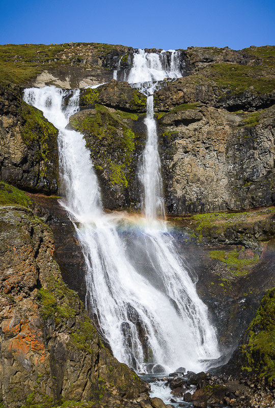
Rjtikandifoss, a 139m waterfall. The Ysti-Rjtikandi River is one of three with the same name and with a source near Mt. Sandfell. The large fall has 4 cascades as it tumbles off the cliffs above. A short trail leads to the base of the falls.
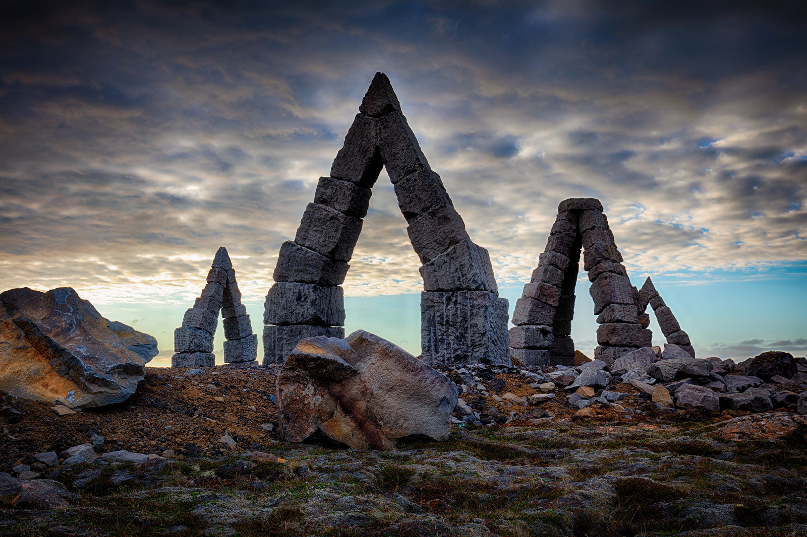
Arctic Henge, Raufarhöfn. On the NE corner of the Malrakkaslétta Peninsula, this is a series of large, stacked basalt arches placed within circles that act as a sundial to capture the midnight sun’s rays and cast shadows in specific locations.
Nearby is the most north part of Iceland’s mainland, 3 km from the Arctic Circle.
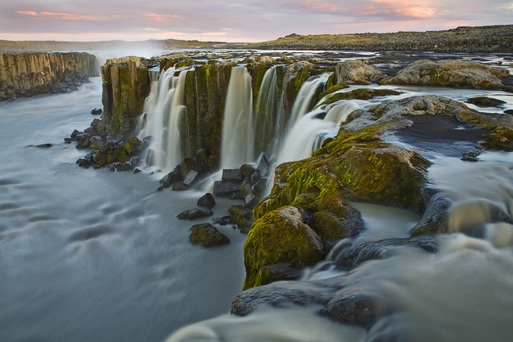
Dettifoss. This 45m-high waterfall is a huge wall of dirty grey-brown water cascading off a 100 m-long diagonal across the Jökulsá River. It is supposedly the most powerful waterfall in Europe. From N1, take the good 862 paved road 27 km north. From the large parking area, it is a .8km walk to the west side of the falls. This is the best view as the diagonal sweep of the falls faces west. There are three viewpoints. Upstream gives the best views of the falls, the rainbow from the huge spray/mist, and the downstream canyon. On the lip of the canyon, it is not possible to see the bottom of the falls because of the huge spray.

On the way back, detour .6km upstream to see the Selfoss that falls 10m in a long horseshoe shape.
Downstream is the 27m Hafragilsfoss; there is a walking trail between Dettifoss and this waterfall.
Dettifoss lies at the south end of Vatnatjökull National Park. The north side of the includes Ásbyrgi Canyon.
Uverin. 6 km east of Reykjahlid and Mývatn and over a low pass, this geothermal area has some great mud pots and fumaroles with several walking paths snaking through the formations. Climb the good path to the small rocky peak to the west for awesome views. This area sits on the mid-Atlantic rift.
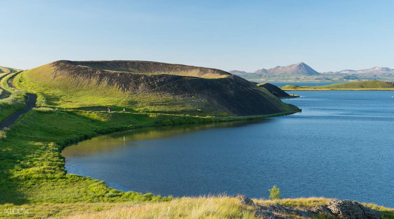
Lake Myvatn. A tentative WHS, this calm, shallow lake is at the heart of a volatile volcanic area with mud pots, craters, lava fields, and fumaroles. It is very shallow. The area has the best summer weather in Iceland. Reykjahlid is the main village.
There are lava formations and the forested lava headland of Höfò in the east, a cluster of pseudocraters on the south at Slitistađir, and great bird watching on the marsh plains on the west (the lake is said to have more species of ducks breeding here than anywhere else in the world).
Hverfell. 5 km east of Reykjahlid is this 1040m diameter, near-symmetrical crater. Take the easy track from the NW corner to the 463m summit for great views of the crater and surrounding landscape.
Dimmuborgir (Dark Castles). This rugged lava field with volcanic caves, chimneys, and pillars has easy walking trails through the formations – the most popular is the 2.3km Church Circle. It is 3kms south of Hverfell.
Mývatn Nature Baths. Northern Iceland’s answer to the Blue Lagoon is 3 km east of Reykjahlid. It has powder blue, mineral-rich waters, and two steam baths. ISK 3500.
Husavik (pop 2300)
Eleven species of whales, dolphins, and porpoises come to Skjàfandi Bay to feed in the summer and Húsavik has become the whale-watching capital of Iceland, best from June to August. See minkes, humpbacks or porpoises, the most common species. Other possibilities are blue, fin, sperm, pilot, sei, killer whales, white-beaked dolphins and harbour porpoises.
Húsavik Whale Museum. The history of whaling in Iceland and several huge skeletons.
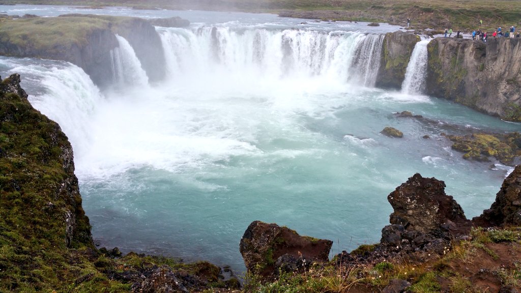
GOĐAFOSS (Waterfall of the Gods). Only 12m high, it has two long cascades. The river is the Skjálfandafljot, at 180 km, the fourth-longest in Iceland. All the lava surrounding the falls originated at the edge of the Vatnajökull Glacier, almost as far away as the origin of the river.
Laufás Heritage Site. 1865 church and old turf farm, a gabled farmhouse, and a maze of interconnected rooms including a bridal room. These turf houses are a Unesco WHS.
Akureyri (pop 18,600). Iceland’s second-largest city sits at the head of Iceland’s longest (60km) fjord, Eyjafjörđur (island fjord), at the base of many snowcapped peaks. It is the hub of commerce, production, arts, culture, and education for north Iceland. It is big enough to have a good night scene. Spread all over Akureyri are open-air sculptures along the Art Trail.
Hilđarfjall, 5 km from the city and with great views of Eyjafjōrđur, is one of the best ski hills in Iceland.
Kjarnaskogur, 10 km south, is Iceland’s most visited forest with 10 km of mountain biking trails and cross-country in the winter.
HOF Cultural and Convention Centre.

Akureyri Museum. Is in a gorgeous house – the 1934 villa Kukjuhvoll.
Mt Súlur (1213m). Above the town, a good trail takes 5-6 hours to return.
TRÖLLASKAGI (Troll Peninsula) is a grand peninsula west of Eyjafjörđur. It has the best scenery I have seen so far in Iceland with big mountains, cliffs, and fjords. There are endless hiking possibilities marked by dashed red lines on all the roadside maps.
ufjörđur is one of the most dramatic in the country through three long tunnels. The first is 3 km long, single-lane, and ends at Olafsfjorđur, a charming fishing town. The second 7 km tunnel is two-lane and brings you to the stunning, uninhabited Héđinsfjorđur valley. The last farms left here in 1951 – life was difficult with heavy snowfall and frequent avalanches.
Day 4
Siglufjordur (pop 1600). This historic fishing town’s appeal now is peaceful isolation.
Sildarminjasafniđ – The Herring Museum tells of the boom years between 1903 and 1968 when all herring disappeared never to return.
Go round the north side of the Troll Peninsula to the dramatic west coastline.
Drangey Island. Is a birdwatcher’s paradise especially for puffins.
Hofsos. This tiny town on the west side of the Troll Peninsula has a famous swimming pool, Infinity Blue (900 Kr) on the cliff edge. Below is a beach with several cliffs of basaltic columns. The Icelandic Emigration Centre tells when 25% of the total population of Iceland left for North America. The climate had been getting colder, crops were worse and then in 1875, the Askja volcano blew spreading ash over large areas making farming impossible. The northeast of the country saw the most migrants. Most went to North Dakota or Canada where there was more land. About 15,000 went to Gimly Manitoba, still an Icelander community.
Grof, just south of Hofsos has a turf church with remnants of the oldest place of worship in the country.
Glaumbær (Skagafjörđur Heritage Museum). The turf farmhouse has been here for 900 years and is part of the Unesco WHS turf houses. The construction is fascinating and best seen in the smithy and store-room as they are not lined with wood walls. A log frame is built and the 1+m wide turf walls are constructed on a rock foundation. ‘Bricks’ of turf are laid at opposing angles on top of each other with each layer of bricks separated by a thin layer of turf. The roof consists of several large thin layers of turf laid on top of wood rafters – about 4 layers on the smithy and storeroom and 10 layers in the house. Long grass waves in the wind on the top. The house consists of about 9-10 adjoining buildings forming a maze of rooms. A complete wood frame with doors in jams and walls makes for almost normal construction. But the rooms are quite dark as the windows are tiny. Each room has period furniture from the 1900s. The buildings all have a wood gable end. ISK 1700
Borgarvirki. Also known as the Citadel, this is a volcanic plug used by the Vikings as a fortress during times of strife. A wonderful view can be had from the 177m top.
Kolugljúfur. Don’t miss this, a series of waterfalls boiling through a narrow gorge with rugged lava walls. A bridge crosses just at the main upper falls. Walk a hundred metres to see the bottom of the falls and a deep canyon. I counted at least 9 separate layers of lava on the walls. Drive 5.7 km southeast of N1 on a potholed dirt road.

The weather turned into dense fog, then heavy rain and strong winds.
Kattarhryggur (Cat’s Arch).
WEST FJORDS. The largest peninsula in Iceland, it juts out on the NW corner of Iceland. The coastline has many long and deep fjords, little coastal lowlands, and a rocky inland with sparse vegetation. The fjords are separated by high mountains impeding transportation so the road hugs the coastline all the way around. Isafjarđarbær (pop 3,710), at the west end of the peninsula, is a municipality containing 4 residential areas (Isafjörđur is the largest with 2,828 people) separated by tall mountains and connected by a tunnel.
Kaldbakur (998m) is the tallest mountain in Westfjords – the area is called the Alps of the Westfjords. The sheer Látrabjarg cliffs rise 440m and are the westernmost point of Europe and Iceland. I didn’t go here – the sinuous drive would have taken 2 days.
SNÆFELLSNES PENINSULA
A jagged ridge of mountains runs the length of the peninsula with Snæfellsjökull at the western end. An extensive lava field extends north, west and south.
Breuđafjörđur. This broad waterway and nature reserve separates the Snæfellsnes from the cliffs of the distant West Fjords and is full of grassy islands with great birdwatching. Boat tours are available from many of the towns.
Stykkishólmur (pop 1173). “The town of a thousand islands” sits at the tip of a peninsula. It has a nice harbour and lovely renovated 19th-century houses. It is the departure point for ferries for the west fjords.
Climb the basalt Mt Helgafell (73m), a culturally famous mountain – an Augustinian monastery was moved here from Flatey Island in 1184.
Mt Kirkjufell (463m). The most photographed mountain in Iceland, it sits alone on a peninsula – all shades of emerald green split by many bands of dark cliffs. A diorama describes the geology: a base of tertiary lava, and then 10 alternating bands of sandstone and the cliffs of quarternary lava (reverse magnetism) deposited in the warm periods between ice ages. The top is tuff. It looks like a difficult climb up the south/southwest ridge to negotiate the cliff bands, some at least 10m high but is possible – the down climbing may be more difficult than going up. A 3-hour walk goes around the base.

The fishing village of Grundarfjöđur sits across the bay. It is the capital of whale watching for the Snæfellsnes. The stone sculptures of the artist Liston are dotted all over town.
Olafsvik. This little town has a stunning church with a slanted tapering steeple and a separate bell tower.
Hellissandđur. The Maritime Museum has 2 turf houses. It is also known for its street art.
Saxhóll. This chocolate brown crater was formed 3-4000 years ago and is 109m above sea level. Climb the clever metal stairs to the top – a round metal disc points to all the surrounding mountains and points of interest. It sits in a large plain of rough, old ah ah lava and a similar crater is a few hundred metres north.

Saxhóll has the start of the best route up Snæfellsjökull. Begin on a trail that disappears in the lava but the way is obvious. It is 5 km from the start of the glacier. Travel on the glacier is discouraged unless accompanied by a guide because of crevasses.
Dritvik. This black sand/cobble beach was the largest spring fishing station in Iceland in the mid-16th to the mid-19th centuries. 40-60 boats employed 200-600 men (farm labour working seasonally in the fishery) in the February to late May season. Four large stones weighing 23, 54, 100, and 154kgs were used to test the strength of prospective rowers in the fishery.
On the way down to the beach, pass rugged lava walls, one with a hole, and two deep pools (Djúpatonsssanđer). This is a busy tourist magnet.
SNÆFELLSJÖKULL NATIONAL PARK
On the west end of the peninsula and extending to the sea, this 170 sq. km park (formed in 2001) surrounds the dormant volcano Snæfell (3 summits the highest is 1440m) known for its large glacier – in 1900 it was 23km2, retreated during the warm period from 1925-66, expanded until 1996 and since has retreated significantly to 12km2 in 2002 and 9km2 in 2012.
The mountain was first climbed in 1754. Outside Iceland’s main volcano zone that crosses the centre of the island, the volcano has erupted 20 times (3 powerful eruptions, the last 1800 years ago) in 11,000 years. All the lava fields surrounding the mountain are post-glacial and mostly covered with Icelandic moss, a constant yellow-tan, and most likely an exuberant type of lichen.
The Gestastofa National Park visitor centre is at Hellnar and has excellent displays on the mountain and fishery. Two 71 and 63-m high volcanic plugs are to the east. There is a lovely lighthouse close to the visitor centre.
Jules Verne’s novel Journey to the Centre of the Earth is about 2 Germans and an Icelander who go down a crater on Snæfellsjökull to reach the middle of the earth and are finally carried by a volcanic eruption to Stromboli, an active volcano off the north shore of Sicily.
Laugarbrekken. Just east of the park visitor centre, this is an old farm site where Guōriöir Borbjainasdötter was born. With her parents, she made an unsuccessful attempt with Eric the Red to reach Vinland (North America) via Greenland and then finally with her second husband led by Lief ‘the Lucky’ Eriksson settled in L’anse aux Meadows on the north tip of Newfoundland in about 1000 AD. She was the first white European woman to give birth in North America. There were many difficulties with the local indigenous tribes and she returned to Iceland with her son Snorri. She subsequently made a pilgrimage to Rome and back and eventually returned to Rome where she became a nun. She was the most travelled Icelandic woman until the 20th century.
At the old farm (abandoned in 1881) is a memorial to her with a lovely statue of her and Snorri.

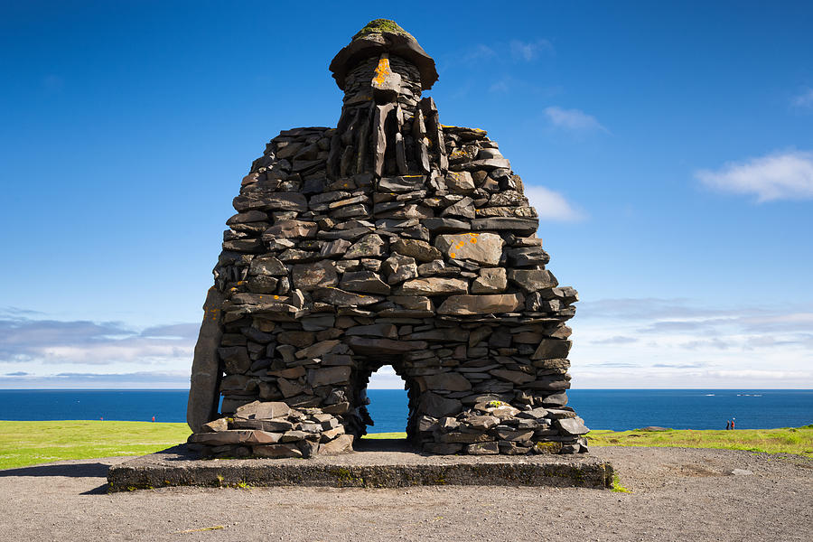
Arnarsstapi. East of the park, this tiny community has a great stone statue of Bárđur Snæfellsás (a mythical figure from the sagas). Walk past the statue to the edge of the cliffs and a lovely walk along the coastal lava field.

Rauđfelđar Canyon. Hike up to this narrow cleft in the rock face with a flowing stream. I was stopped about 30m into the canyon by a 5-foot waterfall topped by a large plug of snow.
The drive along the peninsula’s south coast passes several waterfalls, the most spectacular of which is Bjarnarfoss which drops off the top of a cliff.
Gerđuberg, just north of Road 54, is a magnificent basalt column wall about 3m high.

Old Arkranes Lighthouse. Arkranes was the first town to show signs of becoming an Icelandic fishing village when Bishop Brynjólfur from Skalhot started fishing in 1650 and started selling fish products to Europe. Arkranes is still a flourishing fishing village.
THE GOLDEN CIRCLE
The most popular tourist route in Iceland covers a vast area of geological and historical attractions.
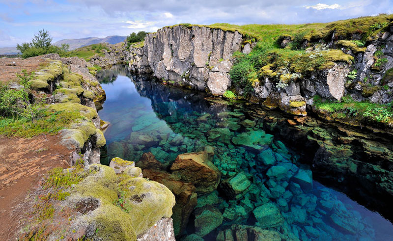
Thingvellir National Park. This is Iceland’s most important historical site – the Vikings established the world’s first democratic parliament, the Althing, here in 930. It is also a superb natural setting on Lake Thingvellin and the edge of the rift caused by the separating North American and Eurasian tectonic plates – the river that feeds into Lake Thingvellin, at 84 sq km and 114m deep, the biggest natural lake in Iceland. The majority of the lake’s inflow is underground. Tingvellir was made a Unesco World Heritage Site in 2006 (Viking Monuments of Iceland).
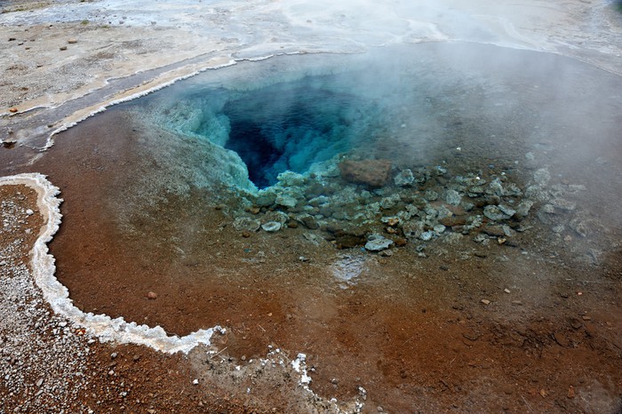
GEYSIR GEOTHERMAL AREA. The Great Geysir erupts infrequently. The world’s most reliable geyser, Strokkur is right next door and erupts every 5 minutes with a dramatic 15-30m plume of water lasting only a few seconds. The area has fumaroles, mud pots, and hot pools. Walk up to a high viewpoint above the whole spectacle. Crowds are immense.

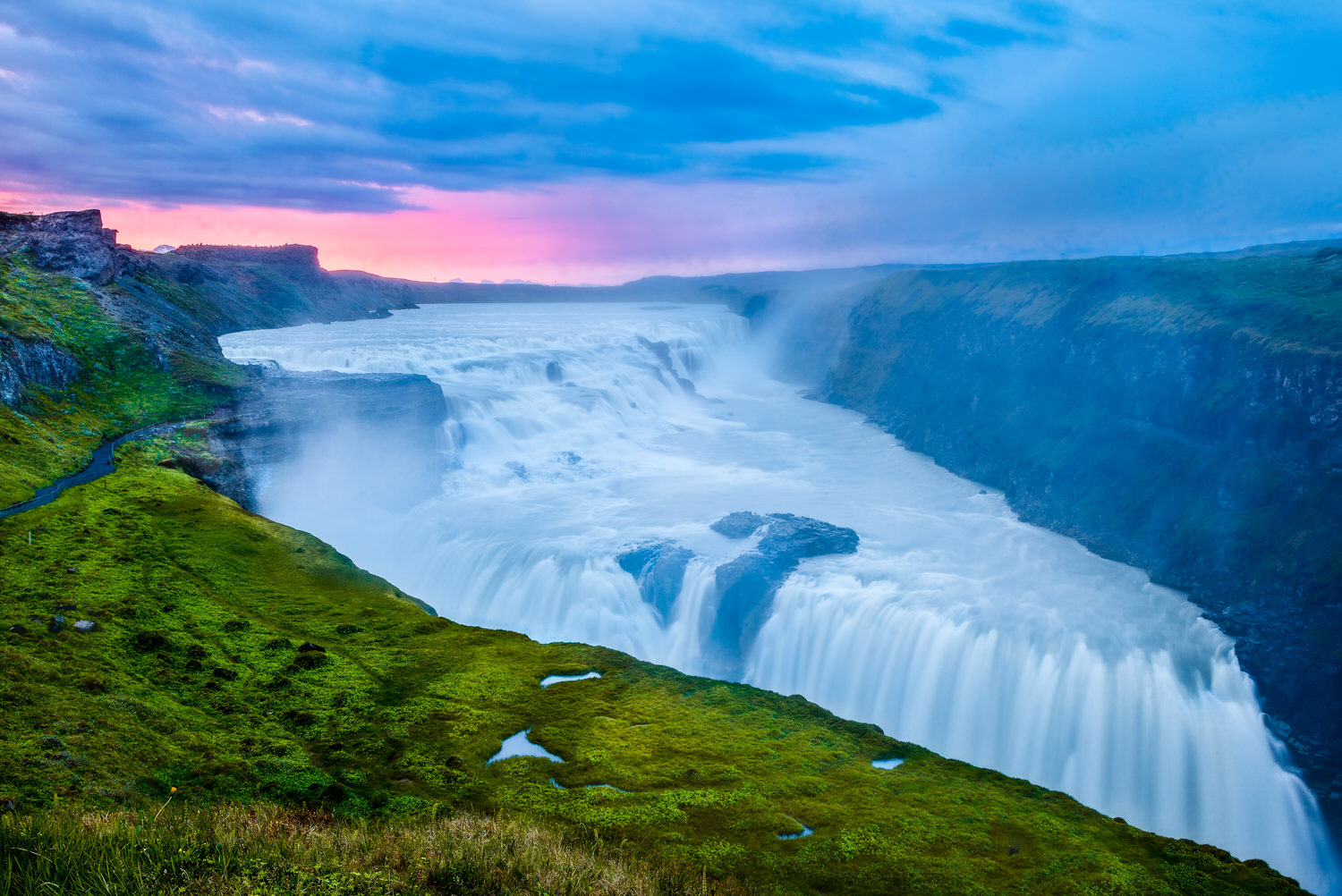
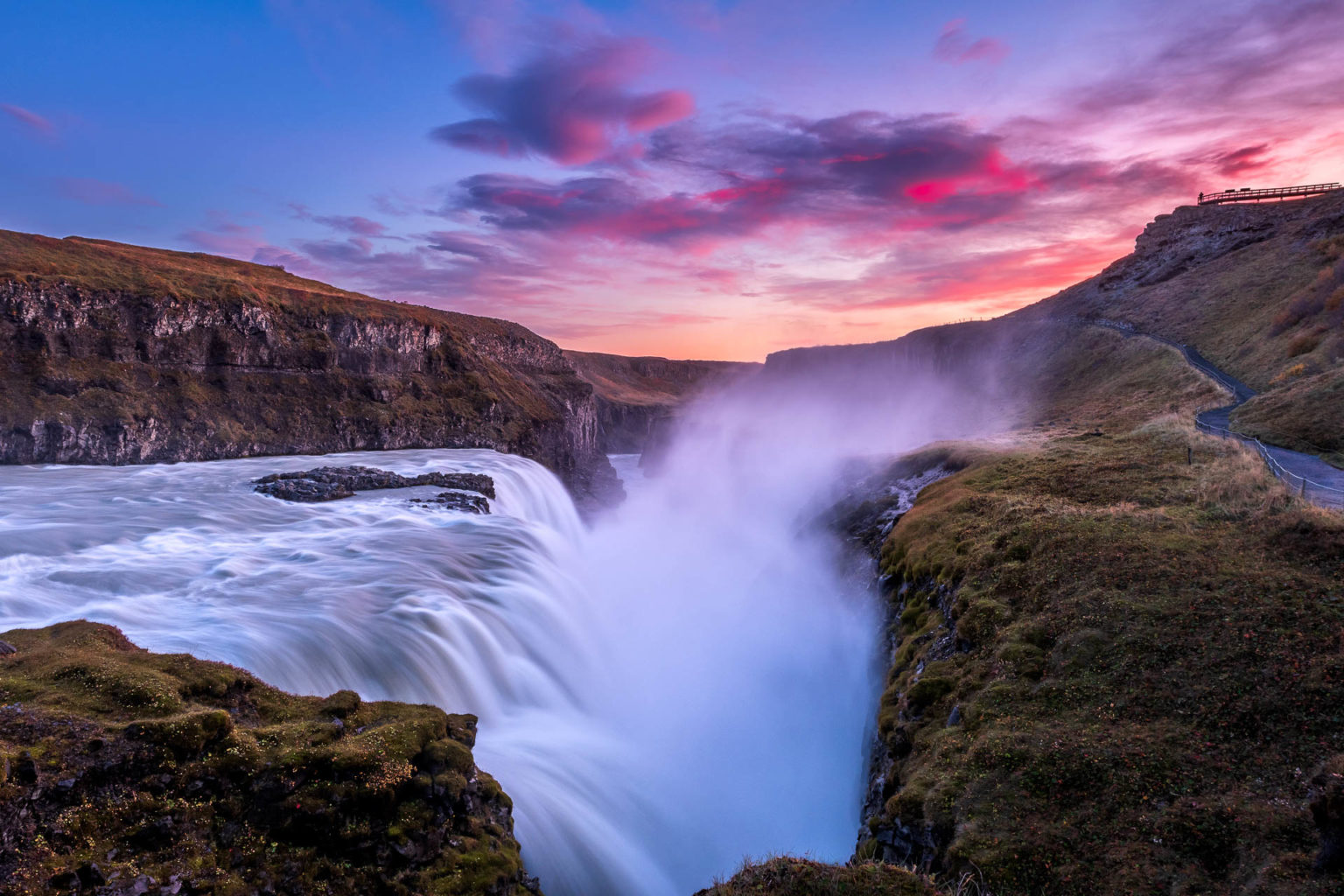
GULLFOSS (Golden Waterfall). Iceland’s most famous waterfall is a spectacular double cascade dropping 32m producing walls of spray before thundering down a rocky ravine. Crowds are huge on several viewing platforms.
Flúöđir and the Secret Lagoon. Hardly a secret, this commercial pool looks natural but is a 1m deep rectangle dugout, sitting on the edge of two 200° hot springs. The temperature varies from 38° to 41° depending on the closeness to the springs. ISK 2800, half-price if over 67.
Skálholt Cathedral. From 1056 to 1786, it was a cultural and political centre.
Visitors can stay here in dormitories, single rooms, and cottages. Many cultural events are held here – most notably the Summer Concerts program in July with classical musicians, and choirs.
The current cathedral is relatively large – 30m from the door to an apse in the new cathedral built from 1956 to 1963. The extensive stained glass windows were a gift from the Danes.
REYKJAVIK (pop 205,000)
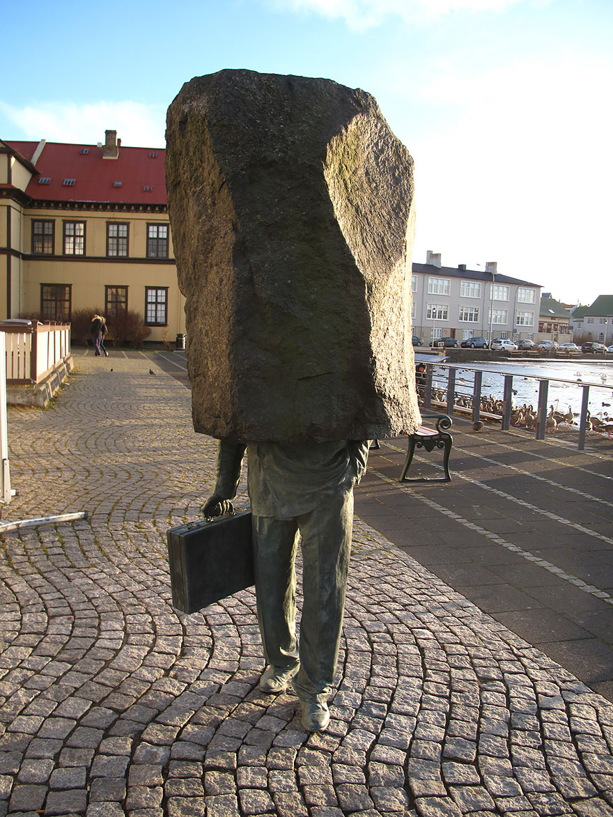
Unknown Official Sculpture. A man from the waist down carrying a suitcase and a large block of stone for his trunk and head.
National Museum.
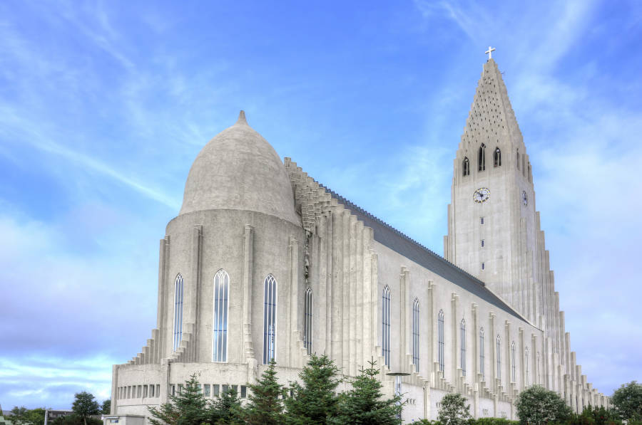
Hallgrimskirkja. Reykjavik’s immense white-concrete cathedral’s 74.5m tower is constructed of ascending hexagonal columns.
Icelandic Phallological Museum. One of the world’s most informative and unusual museums,
Saga Museum. This museum brings Icelandic history to life
Whales of Iceland. 23 life-size models
Harpa. A facade of glass in metal frames forms the structure (the ones in front are hexagonal-like natural basalt columns) – 700 pieces in 70 different sizes give it a “stained glass” appearance. There are 4 concert halls
Laugardalur. 4 km east of the city, was once the city’s hot water supply but now is a huge swimming complex.
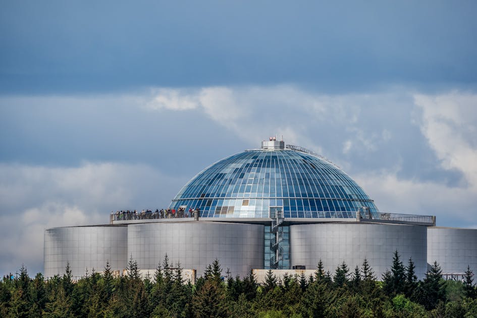
Perlan. The mirrored dome of Perlan covers huge geothermal water tanks.

Viking Museum. Viking ship Islendingur sailed to North America for the 1000-year celebration of Leifur Eriksson’s discovery,
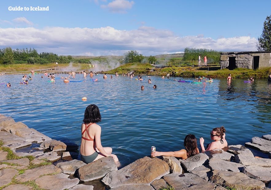
Blue Lagoon. Geothermal energy was discovered here in 1971 and changing facilities built from 1976-87, moved to the present site in the 800-year-old Illauraun Lava field in 1999 and expanded twice in 2007 and 2014.
Tickets must be booked online (www. bluelagoon.com) to get a specific time.

KATLA UNESCO GLOBAL GEOPARK
Katla lies on the Mid-Atlantic Ridge, the most volcanically active area in Iceland. The world’s largest field of cones and most extensive lava fields of modern times are covered in fragile moss.
VESTMANNAEYJAR (Westmann Islands)
This group of 13 jagged islands formed by marine volcanoes about 11,000 years ago. Surtsey, the archipelago’s newest addition rose from the waves in 1963.
Heimacy is the only inhabited island. Its little town and sheltered harbor le between dramatic escarpments and two ominous volcanoes – blood-red Eldfell and conical Helgafell. In 1973, unforgettable pictures of Heimacy were broadcast across the globe when a huge eruption buried a third of the town under 30 million tons of lava.
Eldheimar. Over 400 buildings were lie buried under lava and on the edge of the flow, “Pompei of the North” is the museum resolving around one house excavated from 50m of pumice along with what was formerly Suđurvegur.
Eldfell. This volcano appeared from nowhere in the early hours of Jan 23 1973 and heat from the volcano provided Heimacy with geothermal energy from 1976 to 1985. Today the ground is still hot enough to bake bread or char wood. It is an easy climb from town, up to the collapsed northern wall of the crater.
Edfellshraun. The new land created by the lava flow is now crisscrossed with a maze of hiking tracks.
Skansinn. A 15th-century fort built to defend the harbour, its walls were swallowed by the 1973 lava.
House Graveyard. The edges of the 400 buildings peeking out from the lava at the edge of the town nearest the lava flow.

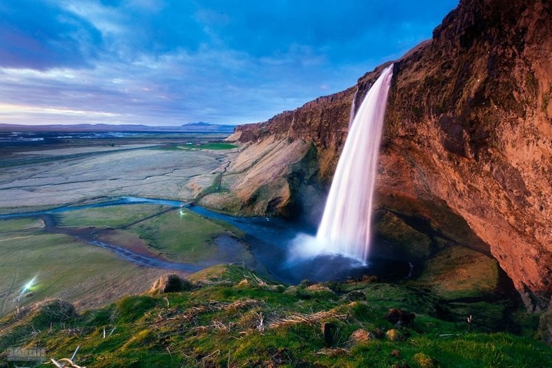
Seijalandsfoss. It forms a powerful wall of water from two glaciers and often produces two rainbows. The walk behind the falls is spectacular but you will get wet from the spray.

Skogafoss. This spectacular, dizzying high waterfall falls into a large bowl, shrouded in mist and rainbows. Climb the 442 steps to a viewing platform with not a great view of the falls. This is the start, or end, of the 23km hike over Fimmvörõuháls Pass to Thórsmörk. From the viewing platform walk as far as you want along the trail that follows the south side of the river. There are some nice falls between stacks of rocks not far along.

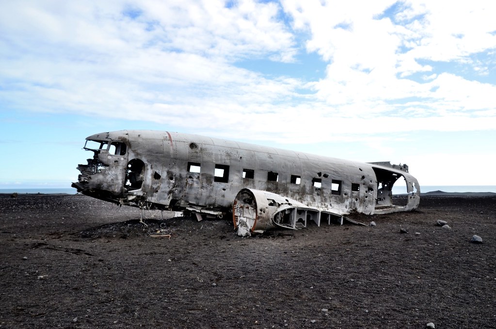
Plane Wreck at Solheimasander. In 1973 a United States Navy DC plane ran out of fuel and crashed on the black beach at Sólheimasandur. Everyone survived. Later it turned out that the pilot had switched over to the wrong fuel tank. The remains are still on the sand very close to the sea. From the car park, walk 7 km, 3-4 hours to return.
Along this section of the road are great views of Mýrdalsjökull Glacier.
Dyrhólaey. This rocky plateau and nature reserve sits separately from the coast at the west end of Reynisfjara black sand beach, 10 km west of Vik. The south end of the plateau is a dramatic thin peninsula with two sea arches, the largest of which allows the passage of a 30-ton ship. The cliffs rise 115m at the 1928 lighthouse (the largest lens in Iceland). There are also several sea stacks, one with 2 arches. There are great views west along the never-ending black sand beach and east to Reynifjara and the stacks at its east end.

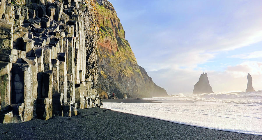
Reynisfjara. Route 215 leads 5 km down to this black sand beach. The main draw is the cluster of grey basalt columns that look like a church organ at the east end of the beach. The cliffs have large caves formed of twisted basalt. A cluster of sea stacks called Reydrangur rises to 63m off the point.
VIK (pop 295). Iceland’s southernmost and rainiest town.
Redranger sea stacks are prominent to the west. Walk from its western end up a trail to the top of 340m Reynisfjall ridge offering superb views down to the sea stacks of Reydranger and Reynisfjara beach.
Vik Church. It has an interesting 4-sided cross and lovely stained glass.

In 1783, a huge lava flow streamed down from Lakagigar in what has become known as the Laki eruption. This is believed to be one of the largest lava flows in the history of the world with 16 cubic kilometres of lava over a 580 km2 area. All around thick woolly fringe moss moss forms a continuous layer. The moss has taken 200 years to grow and is very sensitive to tramping. After passing through this huge field of aa lava covered in lovely Icelandic moss – tan/yellow with a tinge of green – there was a detour of about 50 km, initially on a piece-of-shit, completely wash-board (corrugated in Australia), rough gravel track, then single lane pavement and finally a reasonable pavement road.
The Lakagigar (Laki Craters) is a 25 km long row of craters above Kirkjuhæjarklastur formed from the Laki eruption. They can only be reached by 4×4 vehicles as there are unbridged rivers to cross. They are part of the National Park.
Eldgja is a 40km long eruptive fissure, 600m wide in many places and 200m deep. From 934 to 940, an eruption poured 18 km3 of lava out. The Ofaerufoss Waterfall is located in the middle of the fissure. The area is part of the National Park.
KIRKJUHÆJARKLAUSTUR
First settled by Irish monks, this tiny village is surrounded by historic landmarks. A Benedictine convent existed from 1186 until 1554 and the Reformation. Many things in the area are named after the nuns:
Systrafoss (Sisters Waterfall) is a stunning cascade down a steep rock wall,
Systrastapi (Sisters Rock) where two nuns were buried after being burnt at the stake for indecent sexual behaviour and blasphemy (I believe the rock is the gigantic boulder that the outlet of the waterfall flows under) and Systravatn (Sisters Lake) on top of the cliff that is the source of the waterfall.
There is an unusual modern church with sloping concrete patterned walls down the road.
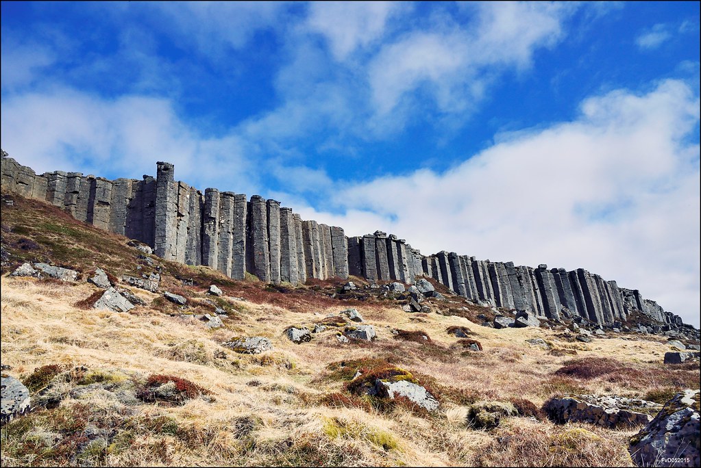
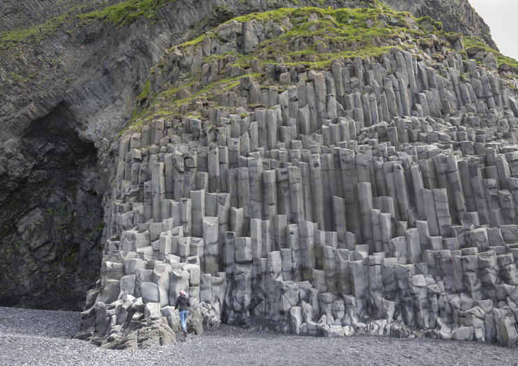
The Church Floor (Kirjugólf) is an eroded columnar basalt outcrop. The columns always stand perpendicular to the cooling surface so are vertical in lava flow, and horizontal in tunnels, but radiate out from the centre of pillow lava. When lava cools, it cracks into columns, usually 5 or 6-sided but can be up to 10-sided.

VATNAJÖKULL
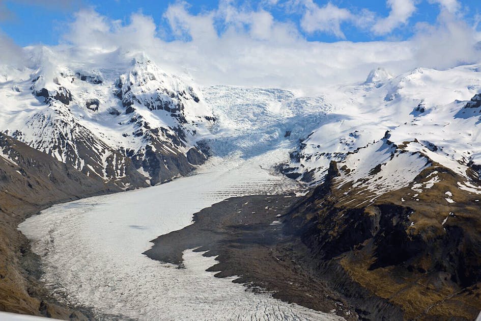
Vatnajökull is the largest glacier icecap outside the Arctic region, with an area of 8100 km2. It measures 950m thick at its thickest point and 400m average. It contains 2000 cubic kilometres of water. It rests on a plateau 600-800m in altitude.
A nunatak named Palsfjall is in the western glacier and a geothermal area and the ancient Grimsvótn volcano is in the middle of the glacier. At least 30 outlet glaciers flow down from Vatnjökull’s bulk, many visible from the Ring Road in the southeast.
ÖKULL NATIONAL PARK
It encompasses the ice cap to form one giant megapark, nearly 14% of the country.
Skaftafell is the main visitor center with access to peaks and glaciers. It’s the country’s favourite wilderness area with at least 300,000 visitors yearly. There are six-day hikes and 3 longer treks. Glacier hikes are a highlight.
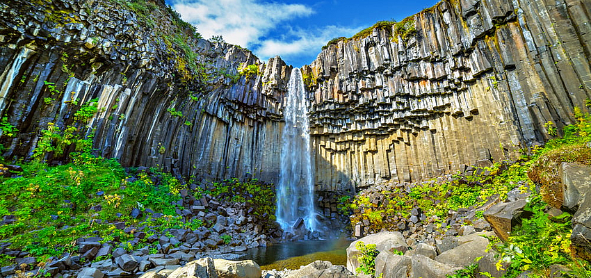
Svartifoss (Black Falls). This stunning waterfall is flanked by geometric black basalt columns. It is reached by a 1.8km trail from the visitor centre via the campsite.
Skaftafellsjökull trail. This 3.7km, 1-hour return walk begins at the visitor centre and leads to the glacier face – much greyer and grittier than you would imagine.
Skaftafellsheiđi trail. A 15.5km, 5-6-hour loop walk.
Öræfajökull glacier is a volcanic crater about 5km in diameter, full of ice. Along its edges, several peaks thrust out of the glacier.
Hvannadalshnùùkur is the highest mountain in Iceland (2110m). The commonest trail is Sandfellsleid which starts at the deserted farm Sandfell.
Fjallsárlón. This small glacial lagoon has multiple icebergs. Boat trips are available.
Jökulsárión. This huge, 25 sq km glacial lagoon sits at the base of Breiđamerkurjökull glacier, an offshoot of Vatnajökull – ice breaks off covering the lake with large chunks of ice before drifting out to sea. It is on the Ring Road between Skaftafell and Höfn. Its short outlet river is only a few hundred metres long before emptying into the ocean.
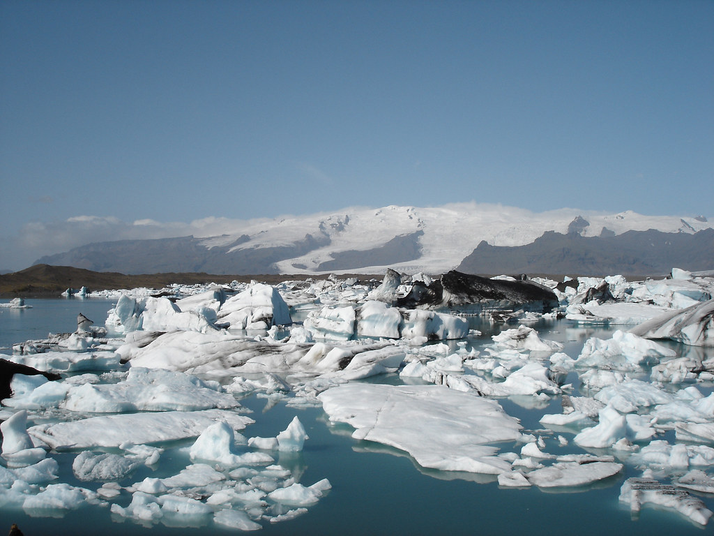
It is another tourist mecca as every tour company stops here.
Heinaberg Mountain, just before Höfn, has sets of basalt columns and a glacial tongue reaching into a lagoon. The 7km long Heinabergsdalur valley used to be damned by glaciers and was full of water.
Höfn (pop 1677). This is the largest town in SE Iceland
The Ring Road takes a very circuitous course as it weaves in and out of several fjords.
Eggin í Gleõvik. In the fishing village of Djúpivogur, these 34 huge egg sculptures each represent the 34 bird species in the area. They line the road along the harbour.
Petra’s Stone Collection. The largest private stone collection in the world is in Stöđvarfjörđur.
Egilsstadir was where I started my way on the Ring Road 2 weeks before.
EAST ICELAND
Listed here are some places to see that I missed – all are along the shores of Lagarfijót Lake and then along the valley extending SW from its end.
Hengifoss. This is Iceland’s third-highest waterfall at 128m. It is 34 km from Eglisstadir near the south end of the longest lake in Iceland, Lagarfijót.
Laugarfellslaug. This is a natural hot spring in the highlands.
Snaefell. Iceland’s highest freestanding mountain (1883m) dominates the view from Fijótsdalshreppur just on the north side of Vatnajökull Glacier.
Kárahnjúkar Hydro-electric dam. The biggest dam in Europe is 97kms from Eglisstadir at the end of a paved road.
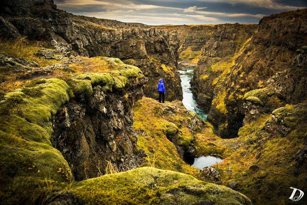
Fjardararglijufur. This magnificent and massive canyon is about 100m deep and about 2kms long. It has sheer walls, is serpentine, and narrow with the river Fjaora flowing in the canyon down into the Skafta River.
I caught the ferry back to Denmark leaving at 10:30 on August 9. After sailing for 16½ hours, we docked in the Faroe Islands for about 44 hours.
