
Namibia Mar 27-April 14, 2017
HIMBA VILLAGE
The Himba have 26,000 members in the tribe, some in north Namibia. The visit is completely authentic. Around a central kraal were several wattle homes with thatch roofs.
Each village had about 30 women and 5 men and supported an orphanage with 50 children. The orphans are most often the result of divorce – a woman cannot get married again with children and the children are abandoned.
Women. All dress traditionally: barefoot, naked on the top, cloth loincloth, ankle bracelets made from barbed wire (15-20 per ankle used to protect their feet in the bush, 2 leather vertical strips show if have had two or more children), many wrist bracelets and multiple leather necklaces. The hair is the most astonishing: about 25 braids coated in an ochre clay/butter mixture and ending in a heavily back-combed ball not covered with clay. The women seemed to spend most of the time backcombing this end in big fluffy balls. The clay covers several braids brought across the top of the head. Married women had animal skin (usually goat) decorations on top. They are completely at ease in their nudity.
The ochre comes from a rock pounded to a fine powder and then mixed with butter. A woman was making butter in a large gourd suspended by thongs and was shaking it.
Girls in early puberty wear their hair in two large braids brought over their heads and hang down in front of their faces. They have a single necklace and single ankle bracelets. Women eligible for marriage have typical adult braids but no animal skin “ornament” on top. They also start removing front teeth at puberty. Biting is done with molars.

Women get married at about age 15-16 and start having babies at 16-17 – often around 8 but as many as 15. The men are polygamous – each wife costs him 5 cattle given to the bride’s family and each wife lives in their hut.
The women never bathe with water but cover themselves with an ochre/butter mixture every day giving their body a red sheen. They take a smoke bath daily to keep insects in their hair and bodies away.
The women may go to school for a few years but most quit as education has little value. They use no birth control. There were no visible old people to see.
Food is mainly a porridge combined with sour milk.
Men. To get married requires about 20 cattle and 5 more for each wife. Because of recent droughts, acquiring enough cattle to get married can be difficult. Boys are circumcised at age 10, women are not circumcised. Men dress in Western styles.
They usually don’t eat meat and mostly raise cattle for milk. The bull calves are castrated and sold at auctions in nearby towns. That is one source of income.
This was an astonishing experience. I had no idea that completely traditional places like this still existed outside uncontacted peoples.
BRANDBERG (Fire Mountain)
At 2573m, Namibia’s highest peak, this massive pink granite bulge has great light at sunset resembling a burning slag heap.
It has the finest remnants of African art, a pictograph, at Tsisab Ravine. The White Lady of the Brandberg is a 40cm figure, part of a bizarre hunting procession. They were produced between 7000 and 4000 years ago. There are several beautifully drawn animals with wonderfully preserved colour: oryx, a wildebeest, zebra, springbok and human figures,


SKELETON COAST
One of the world’s most inhospitable waterless areas, it is soggy, rocky and sandy with rusting shipwrecks flanked by wandering dunes. The coastal shallows have been the graveyard for unwary ships. Early Portuguese sailors called it the Sands of Hell, as once it washed ashore, their fate was sealed. It extends from Sandwich Harbour, south of Swakopmund north to the Kunine River.


Skeleton Coast Park. At Ugabmund, 110km north of Cape Cross, is the entry gate. Fog and dusty sandstorms, eerie, remote and wild, it gets few visitors. Permits require planning as day visits are not allowed and you must pass the entry gate before 1 pm and exit before 3 pm the same day.
Cape Cross Seal Reserve 100,000 cape fur seal population is here because of the rich fish in the cold Benguela Current. There are 25 colonies on the coast.

I left the Oasis trip after Windhoek and rented a car from Budget. I purchased a tire/windscreen addition. Most of the roads are dirt/gravel.
SOSSUSVLEI. Part of Namib-Naukluft Park, this is a pan with towering 300m sand dunes, one of the oldest ecosystems on earth. The Namib Desert stretches for more than 2000km along the coast from the Oliphants River in South Africa to southern Angola.
The gateway to Sossusvlei is 65 km away at Sesreim.
To see the dunes at sunrise, stay in Sesriem and drive to Sossusvlei. The outer park gates open at 6 am and the inner park gate at 5 am. The Sesrium Camp Site is the only accommodation inside the park.
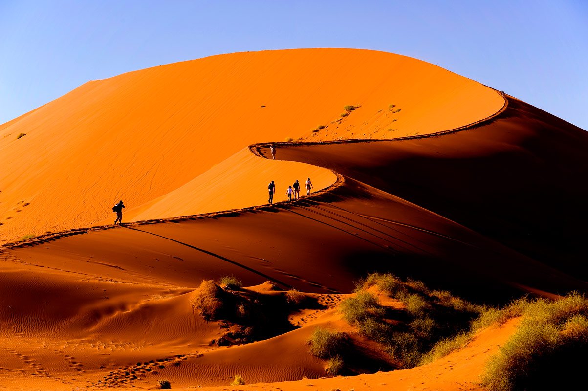
I was up at 4:30. Without a 4WD, virtually everyone takes the open-air shuttles for $150. I walked the 5km into the pan. Dune 45 is the most accessible of the dunes along the road. I started walking to Sossusvlei but then caught a ride on the side runners of a jeep with 4 other hitchers. This is one of those rare walks that could be done in bare feet. Take lots of water.

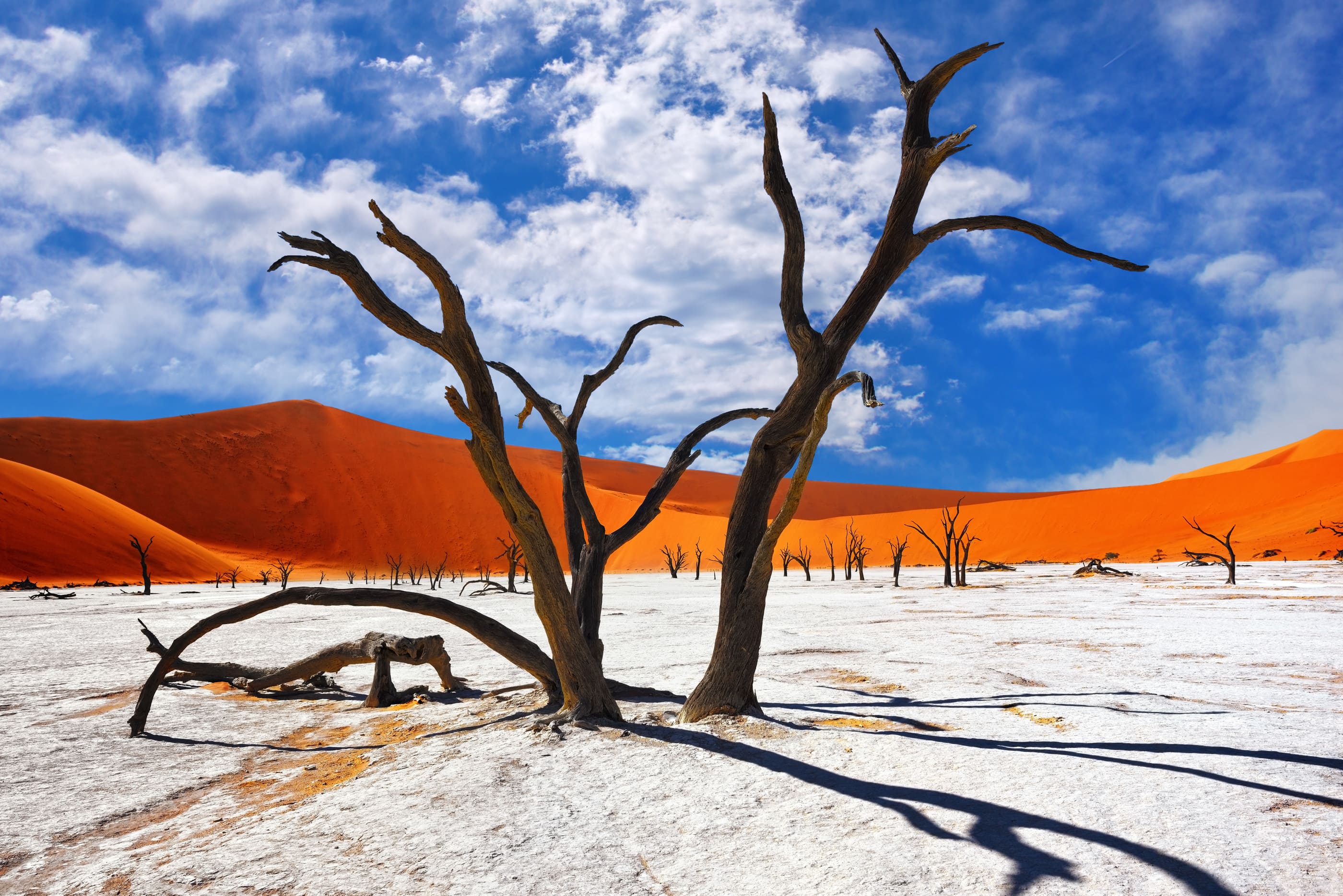
Everyone climbs the “tourist” sand dune in front of the parking lot. It is an easy climb to the crest for wonderful views of a sea of huge red dunes towering over a miraculous white pan dotted with dead trees and riven with a few water courses. The pan is a huge hourglass shape with a large east side devoid of trees. The dead trees form a strong contrast to the white pan.
We sat for at least an hour on top.
It is a great descent down the steep dune face to the pan. The dead flat surface, the result entirely of water deposition, makes it hard and easy to walk through the trees looking up to the massive dunes. Magical.
I walked west over a small dune slope onto another pan, much more broken up with water channels, over the dune saddle at its end and back to the jeep parking area. It was then about an hour walking back to my car.
LUDERITZ. It is known for its German art nouveau and as a colonial town. I was here primarily to go to Kokmanskop and needed to get my permit and pay the fee ($85). The NWR office no longer sells them and I went to Luderitz Safari and Tours on the main street. But everyone else was buying theirs at the gate to the ghost town.
KOKMANSKOP GHOST TOWN. The guided tour sees the bowling alley, ice-making house, and shopkeeper’s house – all windows fixed, sand removed, and furniture.
Established in 1908, the town was built 10 km east of Luderitz. It had everything. 300 white workers and 44 children lived on the south hill.
The diamond processing facility was across the valley – 3 long buildings for the 800 labourers. They lived a completely different life.
The diamonds here are alluvial diamonds – deposited by water flow, carried initially by the Orange River out to the Atlantic Ocean and the Benguela Current that flows north carrying them onto beaches. Additionally to the seashore, storms, rain and wind did the rest to spread the diamonds over a large area of desert. The only mining done initially was surface mining with rows of men laying face first on the ground minutely inspecting every rock.
As a result of this dispersal method, the diamonds are 90% gem quality, the highest in the world. All the poor-quality diamonds would be somewhere out in the ocean. 1000kg of diamonds were removed at Kokmanskop, 20% of the world’s diamonds.
Fresh water was shipped from Cape Town in large barrels and stored in a cistern above town. Sea water was piped from Port Elizabeth and used in the swimming pool, to aid in ice production and diamond processing. Each house got a one-half block of ice and 20l of fresh water and soda water delivered to their house daily by the miniature train that went everywhere.
There was a butcher, baker, general shop and various other enterprises on one of the lower streets. 90% of everything in the town came from Germany.
All but the shop and ice-making facility were full of sand dunes with little to see, save an odd bathtub or sink bolted to the wall.


I started in the museum with great information (one of the best dioramas was methods of stealing diamonds – passenger pigeons, sewing them into their skin and of course swallowing), went up the hill to all the large homes of the chief officer (all windows repaired, all sand removed, walls painted but otherwise bare), teacher (totally fallen in, with a large dune filling it, but the most photographed building in the town), entertainment director and several others. It is a nice walk up the hill to the swimming pool that once had a diving board. The 250-bed hospital was full of sand but interesting for its huge size. I poked through the couples and singles buildings, went to the business street and looked through the bakery. With good light, there would be a million pictures of broken windows, broken floorboards and blocked entrances.

I drove south towards the east end of the Fish River Canyon. The road is well away from the river traveling through the barren rocky mountains and a narrow cut before coming down to the Fish River, much narrower than the orange with rocks and small rapids. A group of 6 monkeys and more baboons were on the road. The mountains across the river in SA were rugged and sharply peaked. This would qualify as a Scenic Byway anywhere in the world.
Then shit befell me. At a left-hand corner, I struck a rock on the road, bent both rims on the left and had two flats. Several stopped and all agreed I was screwed and could expect to sit there for a couple of days.
Then my lucky fairy appeared – a 50-ish man with some original thinking. A big sledgehammer straightened both rims and his compressor inflated the tires. We checked for leaks with water. Four or five more blows of the sledgehammer stopped all the leaks and I had two repaired tires. I put the spare on the front and the least damaged tire on the rear and continued on my journey!
FISH RIVER CANYON. I took Highway C13 north (a gravel superhighway, wide and very smooth) northeast over the broad flat desert to Ai-Ais, a resort with a hot spring on the river at the end of the 5-day hike. I returned the 11km to C13 and continued to Hobas, the entrance to the north end of the canyon. After paying a $80 entrance, I drove the 10 km to the viewpoint above several meanders of the river. Fish River Canyon looks remarkably like the Grand Canyon, just not as deep. The walls are eroded a long way back, there is a broad plateau halfway down (like the Tonto Plateau in the Grand) and the river is often obscured by the steep-walled inner canyon.

The canyon normally opens for hiking on May 1 (the Lonely Planet said April 15 and NWR said May 15 when I emailed them) when water levels are low enough to allow hiking around the pools. It is a 5-day backpack from Hobas to Ai-Ais over 85 km with groups of 3-30/day.
Book with NWR Windhoek 0024/61 285 7200. www.nwr.com.na. as long ahead as possible. It is a popular trip and often books out. A doctor’s certificate is required for everyone, you need your transport and accommodation. A tent may not be necessary but a sleeping bag and pad are. Stay at the Hobas Camp Site 10km from the viewpoint before and after the trip if desired.
I left Fish River before the 8 pm closing time and drove to Windhoek.

