
INCA ROADS
The Inca built a road network that spanned nearly 19,000 miles, between modern-day Colombia, to the north, and Chile and Argentina, to the south. They called it Qhapaq Ñan. The Qhapaq Ñan traverses one of the world’s most extreme terrains, including the driest non-polar desert on earth (the Atacama), steamy rainforests, desiccated salt flats and some of the highest Andean peaks beyond the Himalayas.
The only Inca trail most people have ever heard of is the 26-mile path from Piscacucho (near Cusco, Peru) to the jungle-clad ruins of Machu Picchu. One of the planet’s most iconic treks, it lures some 25,000 hikers each year. Meanwhile, the trails of the greater Qhapaq Ñan network have gone largely unnoticed, unused, and unprotected.
This extraordinary feat of preindustrial engineering allowed the Inca to communicate, exchange goods, and consolidate power during the height of the empire in the late 15th century. It was a line chart for administering an empire.
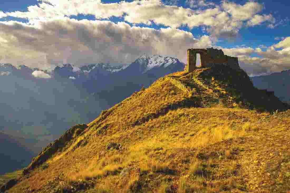
More than a simple path, the Incas crafted it—in many cases, atop existing paths—with a series of stone structures roughly nine miles apart. Called tambos, they were motels, military checkpoints, and supply hubs rolled into one. It rarely heads straight up or down, navigating geographic obstacles (mountains, river valleys) in such a mannered way that groups of soldiers or caravans of llamas could easily tackle it, trudging from tambo to tambo. The Incas perfected everything, from the lengths to the angles, altitudes, steps, and gradients. You couldn’t ask for a better route from point A to point B. The Inca built the trails in very high places because the higher you go in the Andes, the fewer ravines you have to cross and the fewer hassles encountered. There are also more springs, lakes, and water. It was built on the backs of Inca men performing mit’a or mandatory public service. They chewed coca leaves to ward off altitude sickness. It’s hard to understand how these monumental stone paths have been all but forgotten by time.
The sprawling network’s main Peruvian corridor is the 1,800-mile Great Inca Trail. It runs from Cuenca, Ecuador, in the north, to Cusco, Peru, in the south. The higher-altitude sections through the center of Peru—between 11,000 and 15,000 feet, behind the perennially snowcapped peaks of the Cordillera Huayhuash and Cordillera Blanca mountains are the best preserved due to their relative isolation and small population centers. Yet, even here, villagers have removed stones from paths to create corrals for animals or bases for mud-brick homes. Mining companies have also paved over sections of the Qhapaq Ñan to build access roads.
Today, the Great Inca Trail could become an epic tourist route akin to the Pacific Crest Trail. In Peru, the Qhapaq Ñan cuts a swath through the Andes between the Inca archaeological sites of Huánuco Pampa, an Inca city notable for its stone storehouses and a ceremonial ushnu or pyramid and Huarautambo. Work is concentrating on the roughly 100-mile stretch in the middle, offering five-day 50-mile treks north and south of Huánuco Pampa, Temperatures in the winter high season (May to September) can swing from the 60s with blazing sun to the low teens with frost.
INCA TRAIL to Machu Picchu January 17-21, 2012
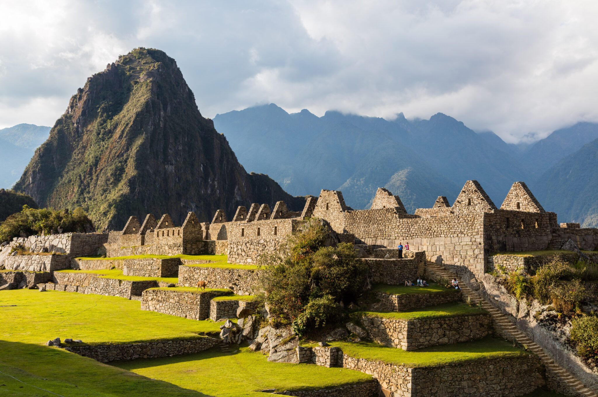
One of the seven modern wonders of the world, Machu Picchu is probably the most important archaeological site in the western hemisphere and a Unesco World Heritage Site since 1983.
It is on everyone’s bucket list and can be visited in many ways including by bus or train (the fastest, easiest and cheapest), or by several trekking routes.
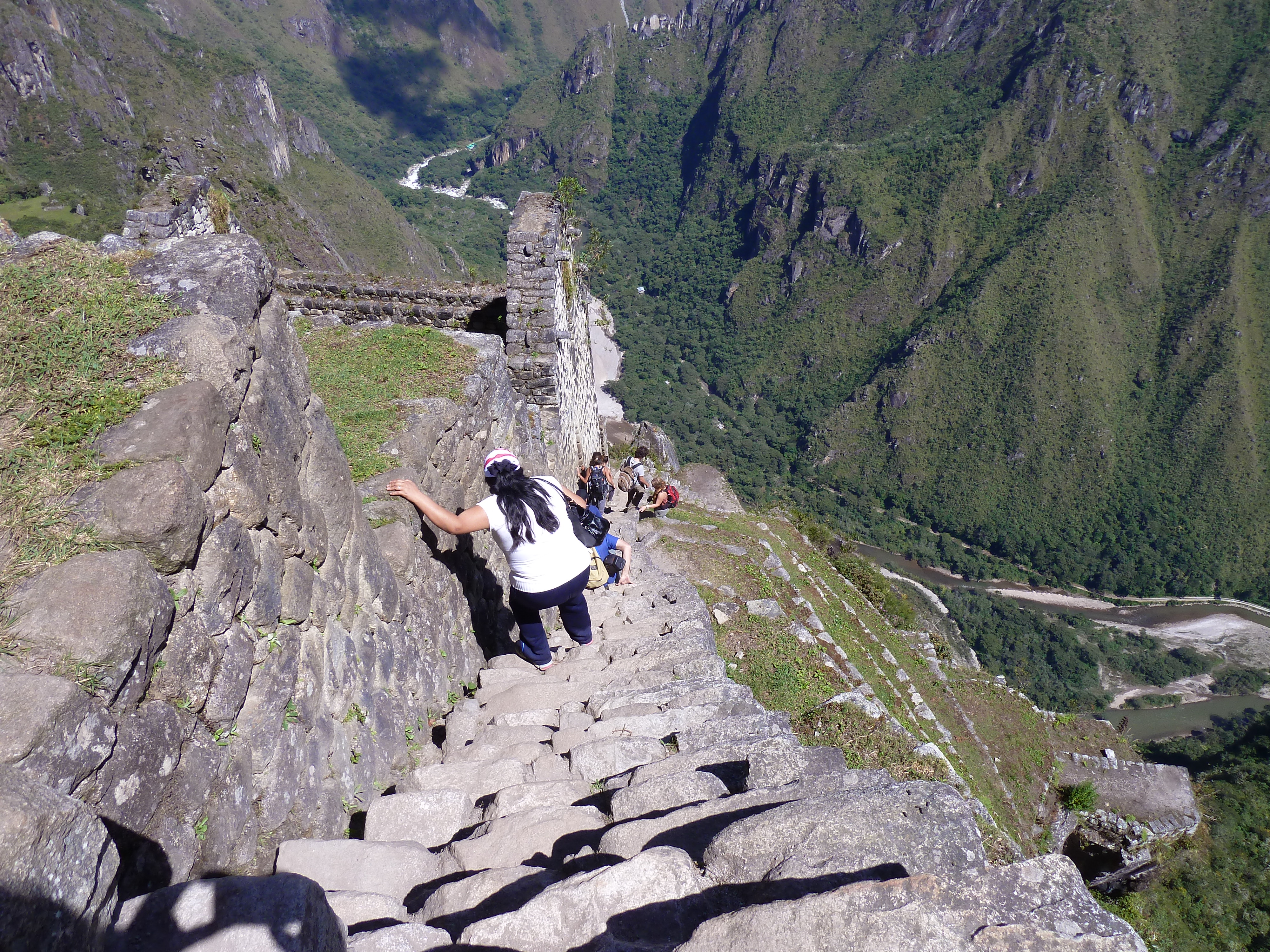
The Inca Trail is a 47 km walk, 80% using the original stone pavers of the Inca Trail to Machu Picchu. At the time it was the only route to Machu Picchu. This is the hardest and most expensive way ($645) and is as much part of the experience as the actual ruins. 500 permits are given per day for the Inca Trail and need to be booked weeks in advance, especially in the busy dry season from May to September. Only 200 permits are for tourists, and the other 300 are for the porters and guides. As it was the rainy season, it rained most days. I used an umbrella, the best way to hike in the rain as it allows great ventilation.
SAS is the biggest company offering the Inca Trail. They provided 2 guides and 21 porters including the cook. The porters carried 27 kg each and had SAS uniforms. There were 15 in our group – I was 62 and the next oldest was 36. By day 2 everyone but me and a fellow from Wales employed porters to carry personal stuff. We carried our sleeping bag, pad and all personal gear while the porters carried the tents, and all cooking and dining gear (including a big eating tent, table and chairs). We were up at 5 every day to eat and start walking by 6:30. The sumptuous meals were almost of gourmet quality. and most of us gained weight despite all the exercise.
The route goes through incredibly steep terrain and narrow valleys.
Day 1. Up at 5 am to bus 3 hours to km 82 on the rail line (elevation 2380m), the trail followed the Urubamba River briefly before starting to climb. Passing 3 Inca ruins, we camped at 3300m in a steep-walled valley.
Day 2 started with a stiff climb over Dead Woman`s Pass, at 4200m, the highest part of the trail, then a descent to 3600m, another ascent to 4000m and then a descent to 3600m again to camp.
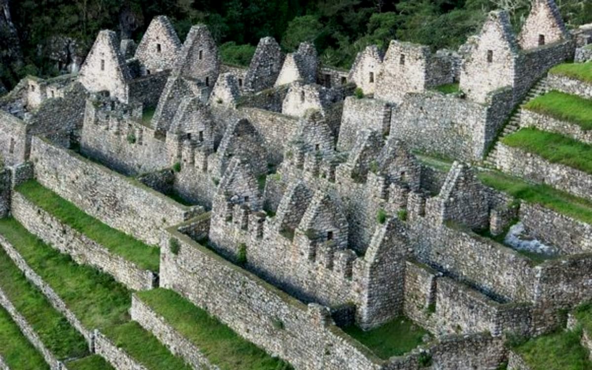
Day 3 was another ascent to 4000m and then a steep knee-destroying descent to 3000m to Wuiñay Wuayna with its tremendous ruin often dubbed ¨little Machu Piccu¨. There were 50 terraces each supported by 5-8 foot stone walls, 14 fountains, many houses, and intricate stonework on the upper ruins.

Day 4 We were up at 3:45 to eat and hurry up and wait for the control point that opened at 5:30. It was then a 60-minute almost level walk through the high jungle with bamboo groves, wood bridges, cliff faces, and rock slides with beautiful views to Inti Punku, the Sun Gate.
The ruins of Machu Picchu were not visible in the clouds but we descended slowly down the steps and path until finally, MP appeared through the clouds – the iconic view that is the visual highlight of the trip.
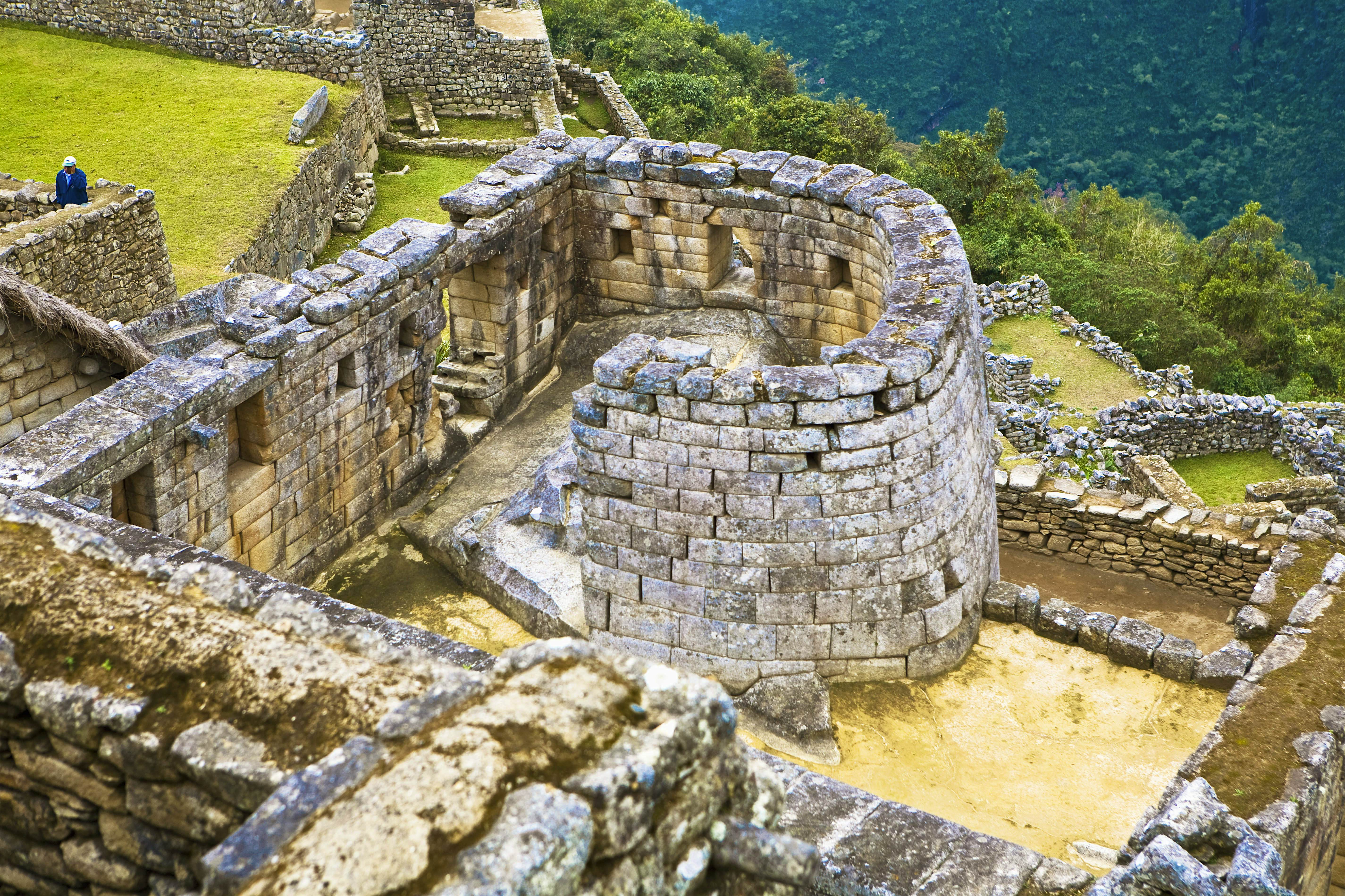
After walking down, we had our guided tour and wandered around the huge site with its many houses, temples, immaculate stonework, and terraces. Our head guide gave us a grandiose tour visiting the main agricultural areas (about 50 terraces from top to bottom), the Temple of the Condor, the Inca`s house, and the main temple with the Three Windows.
 Temple of the Sun with its two windows used to predict the summer and winter solstices,
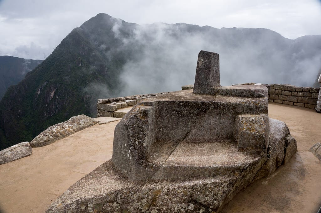 Astronomical Observatory
We cruised through many buildings, then caught a bus down to Aqua Calientes to the hotel, a great buffet lunch and a shower.
Day 5. I bussed back up to the ruins at 6:30 to spend some peaceful time and then climb Waynu Picchu, the mountain behind MP. It was straight up, took 35 minutes and I passed 46 youngsters before the top. MP was in cloud that repetitively opened and closed over the hour I was there. The view was stunning.


On the way down, I took the trail down the backside to visit the Grande Caverns with ruins. It was then a long hike back up to regain the trail.
I then revisited the entire site and eavesdropped on guided tours to gain more insights, especially how the stone was intricately carved and polished to form the seamless joints (nobody can answer this question). I then climbed up to the Inca Bridge, the only other original access to MP other than the Inca Trail. It is an amazing bridge with wood across a big gap in the stone causeway and a vague trail that crosses a vertical cliff face all grown in with trees. The trail is not usable now.

I returned to Aqua Calientes to catch the train back to Ollantaytambo along the incredible Class 5 Urubamba River. Then it was a 1-hour bus ride back to Cusco for a long, exhausting but spectacular day.
