Petra is one of the Wonders of the World.
Day 1 Everyone sees the wonderful rock-cut temples and burial caves. Enter at the Siq and visit all the big sites: Museum at the entrance, Treasury, High Place of Sacrifices, Street of Facades, Theatre, Blue Church, Great Temple, Temple of the Winged Lions, Qasr al-Bint, Al-Habis (the prison), Crusader fort, Lion Tomb, Monastery and the great viewpoints beyond the Monastery.
Day 2 I had three great hikes on my second day at Petra. This was one of the best travel/hiking days of my life. It was hard to fit them all in and a three-day Petra pass made more sense.
WADI MUTHLIM
This adventurous scramble is an exciting alternative route into Petra if you’ve already taken the main path through the Siq. The hike is not difficult or strenuous, but there are several places where you’ll need to lower yourself down pour-offs. Don’t attempt the hike if it has been raining or is likely to rain. As there was a fatality on this route, a guide is now required and the police stop you from entering from the top. I wasn’t stopped.
The trail starts at the dam just to the right of the entrance to the Siq. You almost immediately go through a short tunnel (Nabataean Tunnel). Walk down the rocky creek bed. Some spots have stupendous sandstone – dark red layers alternating with tan-coloured rock. The lower end slots up with some nice narrow, twisty bits.
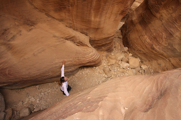
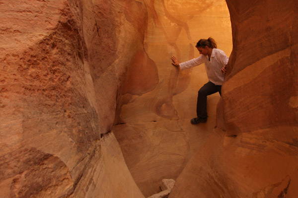
The canyon ends about a kilometre from the Royal Tombs. On the walk back, you pass many rock-cut tombs. A good trail runs just along the south side of the wadi. If the police don’t allow you to walk down the wadi at the top, plan on returning from Petra this way. It is well worth it.
AL-KHUBTHA TRAIL
Before you reach the Royal Tombs from Wadi Muthlim, this “trail” goes up a side canyon to the south. It is a long steep climb up a gorgeous (mostly) rock-cut stairway cut into the cliff face. The first viewpoint gives a hint of the incredible views up ahead. Before the last short bit of stairs is a bench perched at the edge of a 1000-foot drop. The view is of the entire centre of Petra with the theatre to the left and good views down toward the Great Temple and the start of the trail to the Monastery.
Those last stairs bring you to the top of the cliffs above the Royal Tombs. Walk in front of a small “house” rock-cut into a rock bump right at the top, descend a small cliff and walk south along a dirt trail. This eventually leads to a Bedouin home perched on the edge immediately above the Treasury. The views are unbelievably nice.

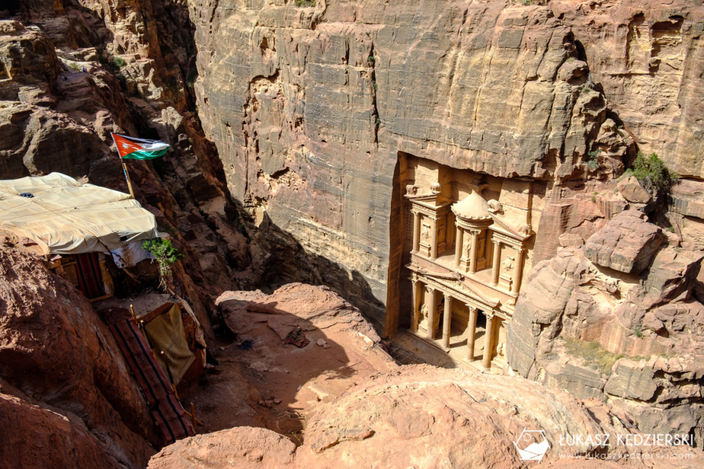
Return the way you came as there is no way down the vertical cliffs. There were a lot of goats at the top. Don’t miss this one.
If planning on doing the Mount Aaron hike, take the time at the top of the Al-Khubtha viewpoints to follow the road that is the first part of the route.
JEBAL HARUM “Mount Aaron” (1270m)
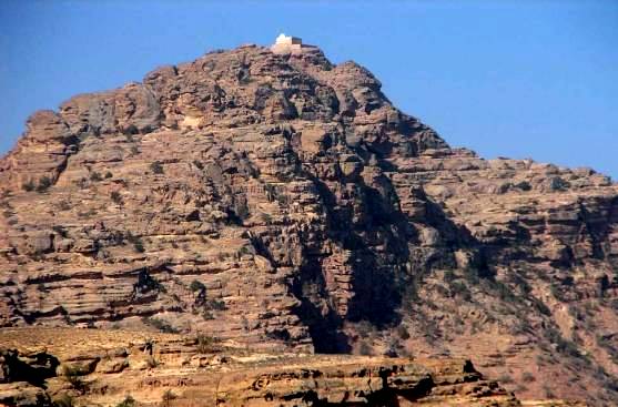
Aaron was Moses’ brother and his tomb is in a sanctuary on the summit of this mountain.
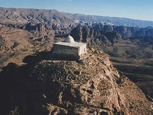
Walk a few hundred meters past the Theatre and take a rocky trail to the left. This eventually hits a dirt road that passes just above the Great Temple.
The first landmark is ‘Amud Fir’awn or the Pharaoh’s Column. This is the solitary column of a ruined sanctuary (on the route to Egypt via Naqa al-Rubai). Just after the column, take the right fork and cross a large wadi (Wadi Ras Suleiman). Continue past several rock-cut tombs and many Bedouin homes to reach a shoulder for the first view of your destination, Jebal Harun with the white tomb of Aaron on top.
Scan the south flank of the mountain to see the faint white zig-zagging trail. Cross two tributaries of the headwaters of another large wadi. At the high point after the first tributary, leave this main road and take a faint track heading west. Scan ahead to the right of the wadi to see the beginning of the trail that winds along the bottom of a hill. Cross the upper end of the wadi, pass in front of a small block building and head up aiming for the start of the trail. The trail is easy to follow to the top of the mountain. Most is slick rock cleared of rocks. When on top of the cliff below the summit block, walk along the west side to the stairway on the north side of the mountain that ascends the cliff face: back to Wadi Musa and for hundreds of miles to the west and north. Climb the narrow stairs on the NW of the tomb to get onto the roof. Descend the way you came.
It took me 2 1/2 hours from just past the Theatre to the summit. On the flank of the mountain, I met a young Bedouin couple with a baby on a donkey. He offered a donkey for 20JD for the remaining hour to the top. I was only interested in walking. As the “keeper of the keys” to the tomb, he then offered to use the key to enter the tomb for 10JD. He discounted the view as being of any importance. We were miles apart on price.
Other Hikes. There are numerous hikes into the hills and siqs around Petra. You need a guide for any hikes requiring overnight stops (it’s not permitted to camp within Petra itself), but many other smaller trails can be easily hiked alone.
Umm al-Biyara. This is a steep hike up the imposing mountain whose sheer cliffs dominate Petra to the west. The steep, exciting route climbs 300m to 1160m at the top. Start as for Jebel Harun to Pharaoh’s Column and cross the wadi. About 100m after crossing the wadi, go right 50m left of some stone tombs. Pass through a rocky defile into a little basin surrounded by caves, up diagonally past more caves then zigzag left and right to enter the gully at a new wall. Ascend the gully on ramps and reach steps, ledges and more steps to the top. On top is an Edomite settlement and Nabataean sites and cisterns.
Refer to the book “JORDAN – Walks, Treks, Caves, Climbs and Canyons”. Wadi Sabra looks interesting.
PETRA
History. There is evidence of habitation 70,000 years ago, houses from the Neolithic period (8500-550BC), Bronze Age (3700-1200BC), Iron Age (the Edomites 1200-539BC), Babylonians (5th century BC) and then the first arrival of the Nabataeans in the 6th century BC.
The spectacular sandstone city of Petra was built in the 3rd century BC by the Nabataeans, nomadic Arabs from NW Saudi Arabia, who controlled the frankincense trade routes of the region in pre-Roman times. They carved palaces, temples, tombs, storerooms and stables from the sandstone cliffs. From here, they commanded the trade routes from Damascus to Arabia, and great spice, silk and slave caravans passed through, paying taxes and protection money.
Petra was at the centre of several trade routes: Egypt to the west, NW by the Mediterranean to Europe, north to the Levant and the Spice route from the east. Frankincense and myrrh (used as incense burned at temples, in burials, for embalming, sacrifices and rituals, it was expensive at the time, but wealthy Romans were willing to pay) were produced in present-day Oman and Yemen (in 100 BC, the Minaen Kingdom in Yemen collapsed and the Nabataeans took over), transported via 65 camel stages over 12 weeks to Petra and onto Gaza, a distance of 2750kms.
They controlled rainwater by building 5 major aqueducts, cisterns and reservoirs, and using clay pipes and waterproof cement. In a short time, the Nabataeans made great advances – they mastered hydraulic engineering, intense agriculture, textile production, iron production, copper and silver refining, glass production, wine production (there were 40 rock-cut wine presses in the Petra area), sculpture and stone carving.
There were 11 Nabataean kings until the last one died in 106 AD. They borrowed architectural ideas from Assyrians, Syrians (arches), Egyptians (obelisks), and Greco-Romans (pediments, capitals, triglyphs, and metopes), all identifiable in the rock-cut structures.
The structures were started at the top and worked down using metal chisels. All was covered with a thin layer of plaster, now mostly gone. The surfaces, corners, and roofs are perfectly done, flat and covered in fine chisel work. Their kingdom at its height supported 20,000 people. It extended from Damascus to NW Saudi Arabia, the Sinai and well past eastern Jordan.
The Romans occupied the area for 2 centuries followed by the Byzantines (324, converted the Monastery and Urn tombs into churches). An earthquake in 363 destroyed much of the water system aqueducts and crumbled the free-standing structures of the Qasr al Bint and the Great Temple. After a second earthquake in 551, the Byzantines moved to Karak. The Umayyads in the 7th century used it as a pilgrimage stop between Damascus and Mecca. The Abbasid Caliphate moved their capital to Baghdad in the 8th century. Crusaders built 3 fortresses here in the 11th century to obstruct pilgrimage routes but were eventually overcome by Saladdin.
It was rediscovered by accident in 1812 by the Swiss explorer, Johan Burckhardt (the same chap who stumbled on the temple at Abu Simbel in Egypt). Until his momentous journey, disguised as an Arab, the neglected city, hidden deep in the rocky valleys of Wadi Musa, had escaped the attention of the Western world for hundreds of years. British explorers came in 1818, French artists in 1827 (the first to find the Monastery), the first American, John Steens in 1832, and the first woman, Charlotte Rowley in 1835. It was a star attraction in the 1989 Indian Jones movie, the Lost Crusade.
A guide costs 50-70 JD (but all info is easily found in the museum and by reading). Avoid the horse ride after the entrance (it is free and included in the ticket, but you will be forced to pay a healthy tip). And be prepared for constant hassles from touts for donkey and camel rides. Bedouins sell trinkets throughout the site.
You approach Petra through the legendary 1.2 km-long, high-sided Wadi Siq.

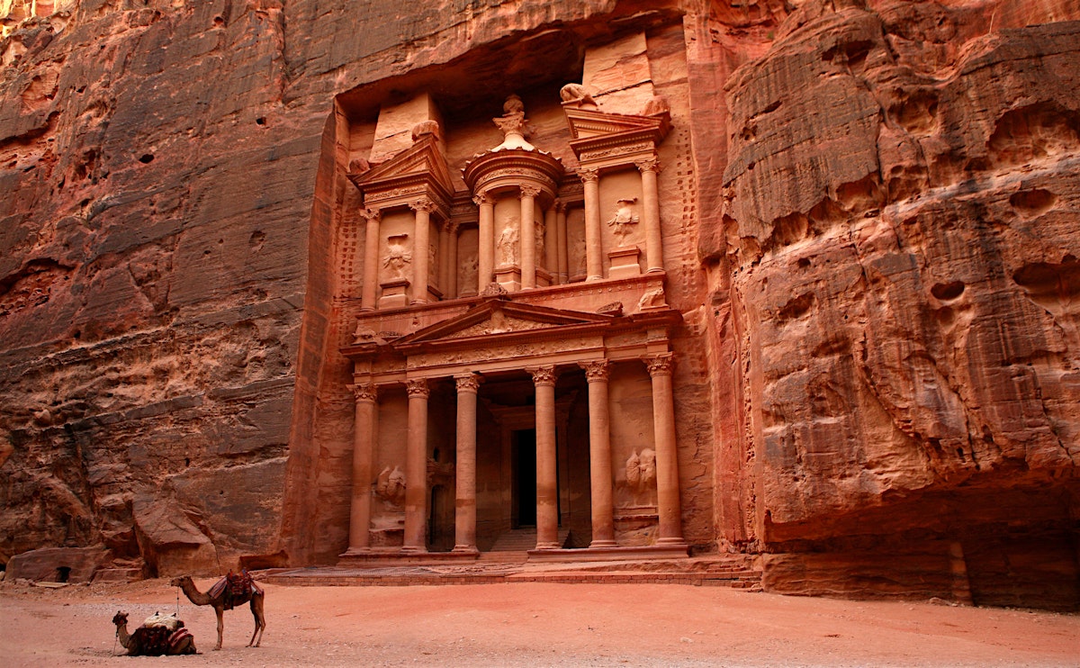
This is not a canyon, but rather a rock mass that has been rent apart by tectonic forces. Just as you start to think there’s no end to the Siq, you catch breathtaking glimpses ahead of the most impressive of Petra’s sights, the Treasury, known locally as Al-Khazneh. 39.5m high, it was carved out of iron-laden sandstone to serve as a tomb to King Aretas IV (9BC-40AD). The Treasury gets its name from the misguided local belief that an Egyptian pharaoh hid his treasure in the top urn. The Greek-style pillars, winged griffins, vases, scrolls, alcoves and plinths are masterpieces of masonry work. In the centre is the goddess Isis surrounded by dancing Amazons.
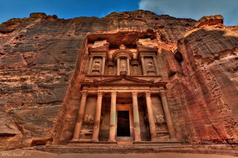
From the Treasury, the way broadens into the Outer Siq, riddled with over 40 tombs known collectively as the Street of Facades.
Just before the theatre, notice a set of steps on the left. These ascend to the High Place of Sacrifice, a hill-top altar. It is an easy but steep 45-minute climb. Descend on the other side of the mountain via the Garden Tomb, Roman Soldier’s Tomb and Garden Triclinium and follow your nose back to the Street of Facades, not far after the Theatre.
The weatherworn 7000-seat Theatre is cut from one piece of stone. It was started by the Nabataeans and enlarged by the Romans,
Almost opposite the Theatre is another set of steps that lead to a fine set of tomb facades cut into the cliffs above. These belong to the Royal Tombs. The tombs have some of the best carving in Petra. They give access to another of the city’s mystic high places, a one-hour climb. Pass the Urn Tomb, with its arched portico. Look for stairs just after the three-storey Palace Tomb. If the tea vendor at the top is available, ask him to show you an aerial view of the Treasury. Return the way you came or search out a set of worn steps leading down a gully to the Urn Tomb.
Returning to the Theatre, the main path turns west along the colonnaded street, which was once lined with shops, passing the rubble of the nymphaeum en route to the elevated Great Temple (a 7500-meter square boasting 60 columns) and the Temple of the Winged Lions on the opposite side of the wadi.
At the end of the colonnaded street, on the left, is the imposing main Nabataean temple known as Qasr al-Bint – 23m high and one of the few free-standing structures in Petra.
From Qasr al-Bint, the path leads to restaurants: (from their prices, it is a good idea to bring your lunch: lunch 10-17JD, drinks 2-4JD).
Behind the Nabataean Tent Restaurant is the small hill of Al-Habis (the prison). A set of steps went up to Al-Habis Museum (now closed and all moved to the new museum at the entrance). From here you can take a path anticlockwise around the hill with fine views overlooking fertile Wadi Siyagh. Eventually, you will come to another set of steps to the top of a hill, the site of a ruined Crusader fort, built in AD 1116. The views across Petra are spectacular. Allow an hour to circumnavigate the hill and reach the fort.
Beside the Basin Restaurant is the opening to Wadi Siyagh and the start of the winding path that climbs to one of Petra’s most beloved monuments, the Monastery. Known locally as Al-Deir, the Monastery is reached by a rock-cut staircase (with 800 steps, it is a 45-minute walk to the top) and is best seen in the late afternoon when the sun draws out the colour of the sandstone. Built as a tomb around 86 BC, with its enormous facade, it was most probably used as a church in Byzantine times.
Spare ten minutes to walk over to the two viewpoints on the nearby cliff tops. See the magnificent rock formations of Petra, Jebel Haroun and even Wadi Araba. On the way back down, look for the Lion Tomb in a gully near the bottom of the path.

On Jan 13, I saw everything above. I spent the day with a very pleasant 48-year-old German fellow. A teacher, he is here during his school’s winter break for 2 weeks and is travelling by bicycle. We sat for a long time in front of the Royal Tombs. We also visited some ruins to the east of the Royal Tombs. The colour of the layered sandstone was amazing.
From the Monastery, there are 2 viewpoints to the west with tremendous views down to some very rugged mountains and the valley in the distance. There I met Mina Guli, a young Australian lawyer running 40 marathons in 7 deserts on 7 continents over 7 weeks to raise awareness for water, its scarcity and the need to conserve it. She runs 6 marathons over 6 days in each desert (Antarctica, Mohave in the USA, Simpson in Australia, Atacama in Chile, Karoo in South Africa, Tabernas in Spain, and Arabian in Jordan) and presumably has a travel day. Go to www.thirstforwater.org to see all the information. She was travelling with 4 young cinematographers filming the runs.
Jordan is the second water-poorest country in the world. We waited for sunset and walked out in the dusk and then dark.
