
OFF-TRAIL HIKING IN WATERTON LAKES NATIONAL PARK
My wife’s family had a beautiful cabin in the Waterton townsite. I had the opportunity to hike, backpack and climb in Waterton Lakes NP and Glacier National Park in Montana for 18 summers. This is where I first started hiking. It is where I developed my love for walking and exploring mountains. I virtually always hiked alone.
Besides hiking all the trails, I climbed every mountain and walked every ridge. I was interested in writing a book on off-trail hiking with the cooperation of the Waterton Lakes Natural History Association. The park service wasn’t keen which is understandable – Waterton is a small park with few places for the animals to go, and encouraging people to go all over the place would be an unwanted side effect.
Days without wind are rare. The average wind speed is 35km/hour but has been 160km/hour. Warm Chinook winds have a dramatic effect on temperatures in the winter. One day in January 1966, in nearby Pincher Creek, Alberta, the temperature rose 21°C in 4 minutes! Waterton has a range of environments, from wetland to prairie to alpine.
Here is a summary of most off-trail hikes available in the park. You will recognize some of the names. Get the paper map and trace out the routes. They involve climbing mountains and walking ridges. My purpose is to give ideas of great places to go that are not in the standard books on hiking. Good topographic maps are necessary to understand where you are going and the scope of the hike. Many are also long days so plan accordingly.
MOUNT FORUM
This mountain is on the BC-Alberta border just above the US-Canada border. It has great views down to Cameron Lake and the big mountains to the south in Glacier NP in Montana. The bear grass is often world-class.
Take the Akamina Parkway 14.4 km and park at the Akamina Pass trailhead. Walk up the trail 1.6km to the pass and turn south to walk up the border cut. It has one very steep part. When you reach the cliff below the top of the mountain, take the animal trail that continues under the cliff to the low point of the ridge where it switchbacks briefly to the top. Turn east and walk up to the summit. The high point could be any of several cairns. It is possible to climb down to a neat marker at the continental divide/ US/Canada border. But it is a difficult scramble.
MOUNT CRANDELL
From the summit, one gets panoramic views of the townsite and down to the hotel and the lake.

From the park visitor’s center, take the trail up to the Bears Hump. Start the big climb up the ridge. At each cliff band, bypass them to the left. There is minimal scrambling to get to the summit. To return, there are three choices. Returning the same way poses some difficulties as from above the route is not obvious even though you just came that way! The ridge down to the NE takes you towards the golf course. My favourite is the long ridge heading west toward Crandell Lake. On top, I once walked beside a large herd of male sheep. Above the lake, pick the easiest way down and then walk around the south side of the mountain back to your vehicle.
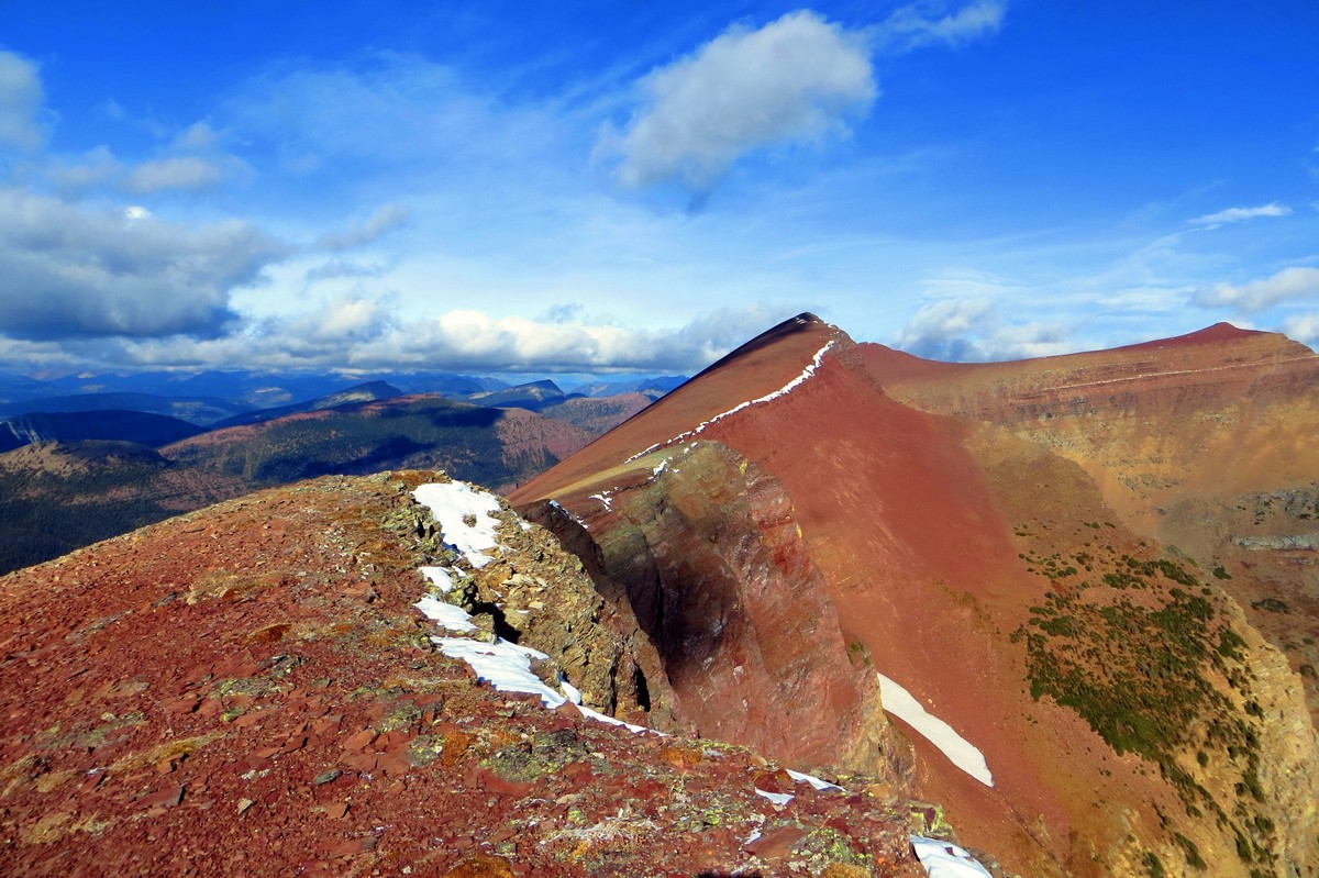
MOUNT BLAKISTON and LINEHAM LAKES
This is the highest mountain in the park and makes a great climb with panoramic views of most of the park. It is in the center of the park. There are five lakes in the Lineham Lakes basin. There used to be a map at the trailhead showing the 100m high Lineham cliff and how to negotiate it, but after an accident, the cables were removed along with the map. The first time I was here, I had never been on the cliff, the route was not obvious from above, and I followed a goat down the cliff to the south of the falls. As few come here because of the cliff, it is a mecca for wildlife.
Drive the Akamina Parkway 9.3 km, park at the Lineham Lakes trailhead and walk the trail until you come to an obvious gully to the west of the summit. After climbing to the top of Blakiston, return along the ridge and continue to circle the north end of the Lineham Lakes basin. Work your way down to the upper lake, walk through the basin and then down Lineham Cliff. One can go down either side of the falls. Both routes are game trails. Although not obvious from above, either way works fine. Work your way down the ledges. I have heard this requires a climbing permit now.

MOUNT VIMY and CRYPT LAKE TRAIL
This mountain across the lake from the town site has great views. Take the ridge to the east and then down to Crypt Lakes, the most popular day hike in the park (although it is certainly not mine). Then take the boat that picks up hikers at the end of the day at the Crypt Lake Trailhead on Waterton Lake.
From the park entrance, take Hwy 5 SE .9km, turn right and drive .5km on the Chief Mountain Hwy 6. Park in the pullout across from the Y Camp access road. Walk down the road 2.6km to the Y Camp and the trail. It is a long boring walk to start the climb (and thus a long way back) and do this only if just climbing Vimy which is a long day in its own right.
As a result, if you want to do the entire loop to Crypt Lake, get a boat ride through the Bosporus to the east shore of Middle Waterton Lake. The trail up Vimy is near the shore. Follow it, turn east at the Vimy junction and scramble up to the summit from the east.
![Vimy Peak Waterton Lake National Park [OC] [6000x4000] : r/EarthPorn](https://i.redd.it/wztx0bgfgom11.jpg)
Then follow the long easy ridge to above Crypt Lake and scramble down the easy slopes to the lake, the tunnel and the crowds. The trail down from Crypt Lake is nice with several waterfalls. The boat makes the trip every day in the summer as the Crypt Lake trail is one of the most popular in the park. Verify the times at the boat dock.

ALDERSON CARTHEW TRAIL – Mount Alderson or Mt Carthew. This is probably the nicest trail hike in the park (and my favourite) but requires a shuttle (or hitchhike from town). It passes past the very pretty Carthew and Alderson Lakes. The mountains are nice climbs. The view from the top of Alderson down to Alderson Lake is dramatic. After climbing Alderson, don’t be tempted to do the Bertha Cirque. One runs into multiple cliffs each requiring difficult down climbs. The one time I did this, I eventually ran out of time and had to descend to the south down to the Boundary Trail and walk home in the dark.
Park at Cameron Lake and take the trail to Summit Lake. Continue on the trail, leaving it to climb Alderson and Carthew, each mountain along obvious routes. For a very long day, climb the ridge off Bertha Peak and go back to town via that trail.
The Alderson Carthew trail comes out right in town next to Cameron Falls after 19km.
WALL LAKE CIRQUE
This hike is not in Waterton but is in Akamina Kishinena PP in SE British Columbia. There are great views down to Wall Lake and south into Glacier NP. The only time I attempted this, the wind was so powerful that you could not move safely without locking arms with your fellow hikers.
Park at the Akaminia Pass trailhead on the Akamina Parkway. Take the trail up to Forum Lake and access the ridge west of the lake. Hike up to the ridge to access Akamina Ridge. Walk over 4 bumps around the cirque above Wall Lake. After descending to the Bennett Pass Trail, turn north and go down to Wall Lake and the trail that returns to Akamina Pass.
RED ROCK CREEK and CLOUDY RIDGE
After a fun wade up the middle of the creek, the walk along the ridge provides great views north of the park boundary.
Park at Red Rock Creek and walk right into the creek marvelling at the incredible colours in the rock. Walk under the bridge and keep going. There are no difficulties. When you reach the Y where 2 creeks meet, head up the ridge between the two and climb Cloudy Ridge. Explore along the ridge and descend any way you think would be the most fun.

AVION RIDGE and GOAT LAKE
This great hike follows a ridge on a standard trail with good views along its entire length. It is a nice scramble down to Goat Lake.
Park at Red Rock Creek and walk 8.2 km to Snowshoe Campground on an old fire road. Take the Avion Ridge trail with huge panoramic views. At the end of the ridge, drop down negotiating two bands of rock outcroppings that form short cliffs into Goat Lake and hike out on the steep trail. Cycling to the Goat Lake TH and ditching your bike here shorten your day by a few hours.

BERTHA PEAK and CARTHEW LAKES
I like the Bertha Lake trail with its 2 waterfalls. The lake is pretty sitting in a hanging valley with a high rock cirque. The cirque is formed from left to right by Mt Richards, Mt Alderson and Bertha Peak. This is the first hike I ever took when I carried my 1-year-old daughter to the lake in a lot of snow.
Cross the bridge at the base of Cameron Falls in the townsite. After .4km turn right on the Bertha Lake Trail. At the lake, access the NE ridge of Bertha Peak. It is a straightforward climb with great views of Upper Waterton Lake. Head down to the northwest to Carthew Lakes. Return on the Alderson Carthew Trail to make a nice loop.
WESTERN BORDER of WATERTON – The Continental Divide
This is a mammoth day hike if one were to try to walk the entire route in one go. It is a long hike to get to the north end of each part. It is only practical to do it in two parts. For both parts, park at the Red Rock Creek parking lot. For the first north section, walk the Snowshoe trail and continue to Twin Lakes. Leave the trail before the lakes and traverse over Kishinena Peak ending at the historically significant South Kootenay Pass where there is a trail. Return on the Blakiston Valley Trail.
For the second part, return to the pass and follow the continental Divide south over multiple mountains including Mt Festubert ending at Akamina Pass and the Akamina Parkway for a big day.
ANDERSON PEAK and MT BAUERMAN
From the Red Rock parking lot, climb the south face of Mt Anderson from Blakiston Creek going up an obvious gully. Turn west and walk the very long ridge over Mt Bauerman ending up above Twin Lakes. Return either by Blakiston Creek or the Snowshoe trail. This is a big day so get a very early start.
ROWE LAKES and LINEHAM RIDGE
Rowe Creek has nice cascades and a red creek bed. Rowe Lakes are lovely and the views from Lineham Ridge are astounding.
Park at the Rowe Lakes trailhead 10.5km along the Akamina Parkway. Instead of going to Upper Rowe Lake, follow the Tamarack trail to access Lineham Ridge. Walk the ridge for great views down to Lineham Lakes. Return the same way. It is impossible to continue on the ridge to Lineham Lakes without a rope.
